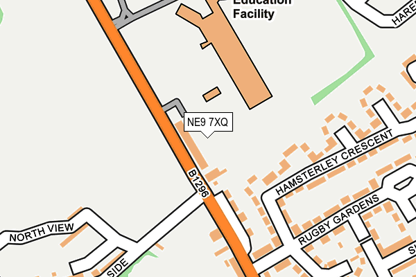
NE9 7XQ is located in the High Fell electoral ward, within the metropolitan district of Gateshead and the English Parliamentary constituency of Gateshead. The Sub Integrated Care Board (ICB) Location is NHS North East and North Cumbria ICB - 13T and the police force is Northumbria. This postcode has been in use since January 1980.


GetTheData
Source: OS OpenMap – Local (Ordnance Survey)
Source: OS VectorMap District (Ordnance Survey)
Licence: Open Government Licence (requires attribution)
| Easting | 427199 |
| Northing | 559519 |
| Latitude | 54.929617 |
| Longitude | -1.577090 |
GetTheData
Source: Open Postcode Geo
Licence: Open Government Licence
| Country | England |
| Postcode District | NE9 |
➜ See where NE9 is on a map ➜ Where is Gateshead? | |
GetTheData
Source: Land Registry Price Paid Data
Licence: Open Government Licence
Elevation or altitude of NE9 7XQ as distance above sea level:
| Metres | Feet | |
|---|---|---|
| Elevation | 150m | 492ft |
Elevation is measured from the approximate centre of the postcode, to the nearest point on an OS contour line from OS Terrain 50, which has contour spacing of ten vertical metres.
➜ How high above sea level am I? Find the elevation of your current position using your device's GPS.
GetTheData
Source: Open Postcode Elevation
Licence: Open Government Licence
| Ward | High Fell |
| Constituency | Gateshead |
GetTheData
Source: ONS Postcode Database
Licence: Open Government Licence
| High Street-moss Side (Old Durham Road) | Wrekenton | 57m |
| High Street-seven Stars Pub (Old Durham Road) | Wrekenton | 61m |
| Cardinal Hume Rc School (Old Durham Road) | Wrekenton | 229m |
| Old Durham Road-whitehouse Lane (Old Durham Road) | Beacon Lough | 324m |
| St Oswald's Rc Primary School (Easington Avenue) | Wrekenton | 381m |
| Heworth Station | 2.8km |
| Dunston Station | 4.7km |
| Newcastle Station | 5km |
GetTheData
Source: NaPTAN
Licence: Open Government Licence
GetTheData
Source: ONS Postcode Database
Licence: Open Government Licence


➜ Get more ratings from the Food Standards Agency
GetTheData
Source: Food Standards Agency
Licence: FSA terms & conditions
| Last Collection | |||
|---|---|---|---|
| Location | Mon-Fri | Sat | Distance |
| Victoria Terrace | 16:30 | 10:30 | 171m |
| Wrekenton Post Office | 17:45 | 12:00 | 531m |
| Beacon Lough Post Office | 17:30 | 12:00 | 586m |
GetTheData
Source: Dracos
Licence: Creative Commons Attribution-ShareAlike
The below table lists the International Territorial Level (ITL) codes (formerly Nomenclature of Territorial Units for Statistics (NUTS) codes) and Local Administrative Units (LAU) codes for NE9 7XQ:
| ITL 1 Code | Name |
|---|---|
| TLC | North East (England) |
| ITL 2 Code | Name |
| TLC2 | Northumberland, and Tyne and Wear |
| ITL 3 Code | Name |
| TLC22 | Tyneside |
| LAU 1 Code | Name |
| E08000037 | Gateshead |
GetTheData
Source: ONS Postcode Directory
Licence: Open Government Licence
The below table lists the Census Output Area (OA), Lower Layer Super Output Area (LSOA), and Middle Layer Super Output Area (MSOA) for NE9 7XQ:
| Code | Name | |
|---|---|---|
| OA | E00041675 | |
| LSOA | E01008221 | Gateshead 021C |
| MSOA | E02001702 | Gateshead 021 |
GetTheData
Source: ONS Postcode Directory
Licence: Open Government Licence
| NE9 7UY | West View | 28m |
| NE9 7LA | Hamsterley Crescent | 178m |
| NE9 7LB | Hamsterley Crescent | 205m |
| NE9 7JT | Victoria Terrace | 207m |
| NE9 7JQ | High Street | 213m |
| NE9 7JU | Rugby Gardens | 214m |
| NE9 7UT | North View | 221m |
| NE9 7US | Heatherdale Terrace | 235m |
| NE9 7JY | Marlborough Crescent | 252m |
| NE9 7LL | Plawsworth Gardens | 303m |
GetTheData
Source: Open Postcode Geo; Land Registry Price Paid Data
Licence: Open Government Licence