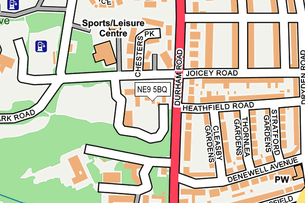
NE9 5BQ is located in the Low Fell electoral ward, within the metropolitan district of Gateshead and the English Parliamentary constituency of Gateshead. The Sub Integrated Care Board (ICB) Location is NHS North East and North Cumbria ICB - 13T and the police force is Northumbria. This postcode has been in use since November 2011.


GetTheData
Source: OS OpenMap – Local (Ordnance Survey)
Source: OS VectorMap District (Ordnance Survey)
Licence: Open Government Licence (requires attribution)
| Easting | 425702 |
| Northing | 560599 |
| Latitude | 54.939401 |
| Longitude | -1.600354 |
GetTheData
Source: Open Postcode Geo
Licence: Open Government Licence
| Country | England |
| Postcode District | NE9 |
➜ See where NE9 is on a map ➜ Where is Gateshead? | |
GetTheData
Source: Land Registry Price Paid Data
Licence: Open Government Licence
Elevation or altitude of NE9 5BQ as distance above sea level:
| Metres | Feet | |
|---|---|---|
| Elevation | 80m | 262ft |
Elevation is measured from the approximate centre of the postcode, to the nearest point on an OS contour line from OS Terrain 50, which has contour spacing of ten vertical metres.
➜ How high above sea level am I? Find the elevation of your current position using your device's GPS.
GetTheData
Source: Open Postcode Elevation
Licence: Open Government Licence
| Ward | Low Fell |
| Constituency | Gateshead |
GetTheData
Source: ONS Postcode Database
Licence: Open Government Licence
| Durham Road-musgrave School (Durham Road) | Low Fell | 155m |
| Durham Road-musgrave School (Durham Road) | Low Fell | 192m |
| Durham Road - Beaconsfield Road (Durham Road) | Low Fell | 231m |
| Beaconsfield Road | Low Fell | 262m |
| Bell Vue Bank-durham Road (Belle Vue Bank) | Low Fell | 267m |
| Dunston Station | 2.9km |
| Heworth Station | 3.2km |
| Newcastle Station | 3.4km |
GetTheData
Source: NaPTAN
Licence: Open Government Licence
GetTheData
Source: ONS Postcode Database
Licence: Open Government Licence


➜ Get more ratings from the Food Standards Agency
GetTheData
Source: Food Standards Agency
Licence: FSA terms & conditions
| Last Collection | |||
|---|---|---|---|
| Location | Mon-Fri | Sat | Distance |
| Low Fell Post Office | 17:45 | 12:00 | 280m |
| Musgrave Road | 16:00 | 11:15 | 299m |
| Dryden Road | 16:15 | 11:15 | 342m |
GetTheData
Source: Dracos
Licence: Creative Commons Attribution-ShareAlike
The below table lists the International Territorial Level (ITL) codes (formerly Nomenclature of Territorial Units for Statistics (NUTS) codes) and Local Administrative Units (LAU) codes for NE9 5BQ:
| ITL 1 Code | Name |
|---|---|
| TLC | North East (England) |
| ITL 2 Code | Name |
| TLC2 | Northumberland, and Tyne and Wear |
| ITL 3 Code | Name |
| TLC22 | Tyneside |
| LAU 1 Code | Name |
| E08000037 | Gateshead |
GetTheData
Source: ONS Postcode Directory
Licence: Open Government Licence
The below table lists the Census Output Area (OA), Lower Layer Super Output Area (LSOA), and Middle Layer Super Output Area (MSOA) for NE9 5BQ:
| Code | Name | |
|---|---|---|
| OA | E00041780 | |
| LSOA | E01008239 | Gateshead 020D |
| MSOA | E02001701 | Gateshead 020 |
GetTheData
Source: ONS Postcode Directory
Licence: Open Government Licence
| NE9 5BG | Telford Close | 31m |
| NE9 5BF | Mcmillan Close | 34m |
| NE9 5AT | Joicey Road | 70m |
| NE9 5PB | Chesters Close | 72m |
| NE9 5AL | Durham Road | 77m |
| NE9 5YW | Chesters Park | 122m |
| NE9 5HL | Cleasby Gardens | 134m |
| NE9 5TD | Hawthorn Gardens | 162m |
| NE9 5HJ | Thornlea Gardens | 178m |
| NE9 5HN | Joicey Road | 182m |
GetTheData
Source: Open Postcode Geo; Land Registry Price Paid Data
Licence: Open Government Licence