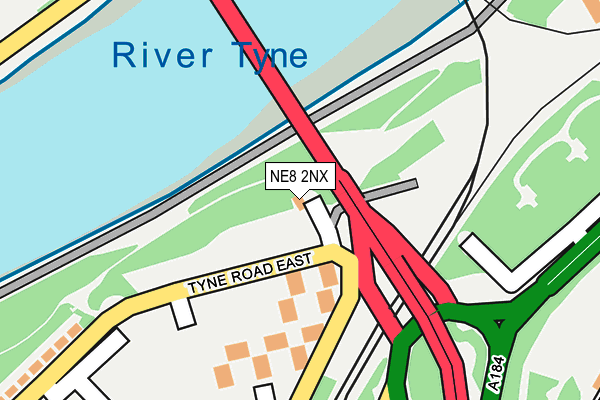
NE8 2NX lies on Lovett Walk in Gateshead. NE8 2NX is located in the Dunston and Teams electoral ward, within the metropolitan district of Gateshead and the English Parliamentary constituency of Gateshead. The Sub Integrated Care Board (ICB) Location is NHS North East and North Cumbria ICB - 13T and the police force is Northumbria. This postcode has been in use since January 1980.


GetTheData
Source: OS OpenMap – Local (Ordnance Survey)
Source: OS VectorMap District (Ordnance Survey)
Licence: Open Government Licence (requires attribution)
| Easting | 424572 |
| Northing | 562936 |
| Latitude | 54.960458 |
| Longitude | -1.617792 |
GetTheData
Source: Open Postcode Geo
Licence: Open Government Licence
| Street | Lovett Walk |
| Town/City | Gateshead |
| Country | England |
| Postcode District | NE8 |
➜ See where NE8 is on a map ➜ Where is Gateshead? | |
GetTheData
Source: Land Registry Price Paid Data
Licence: Open Government Licence
Elevation or altitude of NE8 2NX as distance above sea level:
| Metres | Feet | |
|---|---|---|
| Elevation | 30m | 98ft |
Elevation is measured from the approximate centre of the postcode, to the nearest point on an OS contour line from OS Terrain 50, which has contour spacing of ten vertical metres.
➜ How high above sea level am I? Find the elevation of your current position using your device's GPS.
GetTheData
Source: Open Postcode Elevation
Licence: Open Government Licence
| Ward | Dunston And Teams |
| Constituency | Gateshead |
GetTheData
Source: ONS Postcode Database
Licence: Open Government Licence
| Tyne Road East (Tyne Road) | Teams | 70m |
| Tyne Road East | Teams | 95m |
| Redheugh Bridge Road | Teams | 98m |
| Redheugh Bridge Road | Teams | 104m |
| Tyne Road | Teams | 127m |
| Gateshead (Tyne And Wear Metro Station) (Bensham Road) | Gateshead | 891m |
| Central Station (Tyne And Wear Metro Station) (Neville Street) | Newcastle Upon Tyne | 969m |
| Monument (Tyne And Wear Metro Station) (Blackett Street) | Newcastle Upon Tyne | 1,498m |
| Newcastle Station | 0.9km |
| Manors Station | 1.6km |
| Dunston Station | 1.9km |
GetTheData
Source: NaPTAN
Licence: Open Government Licence
GetTheData
Source: ONS Postcode Database
Licence: Open Government Licence


➜ Get more ratings from the Food Standards Agency
GetTheData
Source: Food Standards Agency
Licence: FSA terms & conditions
| Last Collection | |||
|---|---|---|---|
| Location | Mon-Fri | Sat | Distance |
| Tyne Road East | 17:30 | 12:30 | 151m |
| Askew Road | 16:00 | 12:00 | 378m |
| Walker Terrace | 17:30 | 12:00 | 724m |
GetTheData
Source: Dracos
Licence: Creative Commons Attribution-ShareAlike
The below table lists the International Territorial Level (ITL) codes (formerly Nomenclature of Territorial Units for Statistics (NUTS) codes) and Local Administrative Units (LAU) codes for NE8 2NX:
| ITL 1 Code | Name |
|---|---|
| TLC | North East (England) |
| ITL 2 Code | Name |
| TLC2 | Northumberland, and Tyne and Wear |
| ITL 3 Code | Name |
| TLC22 | Tyneside |
| LAU 1 Code | Name |
| E08000037 | Gateshead |
GetTheData
Source: ONS Postcode Directory
Licence: Open Government Licence
The below table lists the Census Output Area (OA), Lower Layer Super Output Area (LSOA), and Middle Layer Super Output Area (MSOA) for NE8 2NX:
| Code | Name | |
|---|---|---|
| OA | E00041899 | |
| LSOA | E01008258 | Gateshead 007C |
| MSOA | E02001688 | Gateshead 007 |
GetTheData
Source: ONS Postcode Directory
Licence: Open Government Licence
| NE8 2JX | Askew Road West | 286m |
| NE8 2LX | St Cuthberts Road | 378m |
| NE8 2PZ | Morrison Street | 432m |
| NE8 1PJ | Windmill Way | 449m |
| NE8 2LS | Rose Street | 454m |
| NE8 2FA | Worsdell Drive | 456m |
| NE8 1PW | Village Heights | 479m |
| NE8 1NU | Windmill Way | 486m |
| NE8 1NZ | Bridges View | 494m |
| NE8 1PX | Bensham Road | 496m |
GetTheData
Source: Open Postcode Geo; Land Registry Price Paid Data
Licence: Open Government Licence