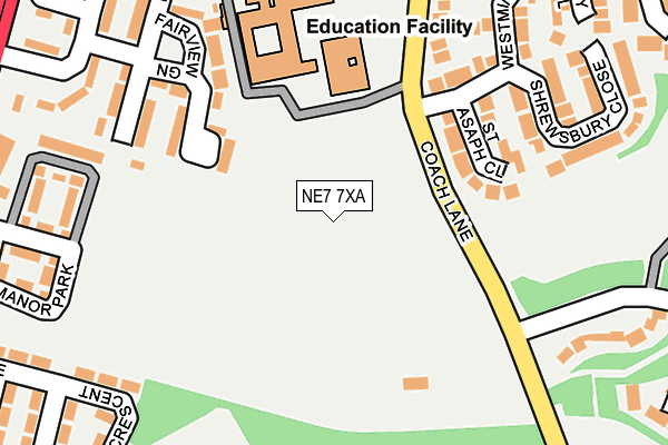
NE7 7XA is located in the Manor Park electoral ward, within the metropolitan district of Newcastle upon Tyne and the English Parliamentary constituency of Newcastle upon Tyne East. The Sub Integrated Care Board (ICB) Location is NHS North East and North Cumbria ICB - 13T and the police force is Northumbria. This postcode has been in use since February 2008.


GetTheData
Source: OS OpenMap – Local (Ordnance Survey)
Source: OS VectorMap District (Ordnance Survey)
Licence: Open Government Licence (requires attribution)
| Easting | 427348 |
| Northing | 567717 |
| Latitude | 55.003283 |
| Longitude | -1.574001 |
GetTheData
Source: Open Postcode Geo
Licence: Open Government Licence
| Country | England |
| Postcode District | NE7 |
➜ See where NE7 is on a map ➜ Where is Newcastle upon Tyne? | |
GetTheData
Source: Land Registry Price Paid Data
Licence: Open Government Licence
Elevation or altitude of NE7 7XA as distance above sea level:
| Metres | Feet | |
|---|---|---|
| Elevation | 60m | 197ft |
Elevation is measured from the approximate centre of the postcode, to the nearest point on an OS contour line from OS Terrain 50, which has contour spacing of ten vertical metres.
➜ How high above sea level am I? Find the elevation of your current position using your device's GPS.
GetTheData
Source: Open Postcode Elevation
Licence: Open Government Licence
| Ward | Manor Park |
| Constituency | Newcastle Upon Tyne East |
GetTheData
Source: ONS Postcode Database
Licence: Open Government Licence
| Coach Lane Campus (Coach Lane) | Cochrane Park | 167m |
| Coach Lane Campus (Coach Lane) | Cochrane Park | 239m |
| Benton Road-fairville Crescent (Benton Road A188) | High Heaton | 277m |
| Benton Road-manor Park (Benton Road) | High Heaton | 300m |
| Coach Lane-playing Fields (Coach Lane) | Cochrane Park | 310m |
| Four Lane Ends (Tyne And Wear Metro Station) (A188 Benton Road) | Four Lane Ends | 817m |
| Benton (Tyne And Wear Metro Station) (Station Approach) | Benton | 1,227m |
| Longbenton (Tyne And Wear Metro Station) (Leaholm Road) | Longbenton | 1,281m |
| Manors Station | 3.9km |
| Newcastle Station | 4.8km |
GetTheData
Source: NaPTAN
Licence: Open Government Licence
GetTheData
Source: ONS Postcode Database
Licence: Open Government Licence


➜ Get more ratings from the Food Standards Agency
GetTheData
Source: Food Standards Agency
Licence: FSA terms & conditions
| Last Collection | |||
|---|---|---|---|
| Location | Mon-Fri | Sat | Distance |
| Church Green | 17:30 | 12:15 | 183m |
| Fairways Avenue | 17:30 | 12:00 | 196m |
| Manor Road | 17:30 | 12:00 | 395m |
GetTheData
Source: Dracos
Licence: Creative Commons Attribution-ShareAlike
The below table lists the International Territorial Level (ITL) codes (formerly Nomenclature of Territorial Units for Statistics (NUTS) codes) and Local Administrative Units (LAU) codes for NE7 7XA:
| ITL 1 Code | Name |
|---|---|
| TLC | North East (England) |
| ITL 2 Code | Name |
| TLC2 | Northumberland, and Tyne and Wear |
| ITL 3 Code | Name |
| TLC22 | Tyneside |
| LAU 1 Code | Name |
| E08000021 | Newcastle upon Tyne |
GetTheData
Source: ONS Postcode Directory
Licence: Open Government Licence
The below table lists the Census Output Area (OA), Lower Layer Super Output Area (LSOA), and Middle Layer Super Output Area (MSOA) for NE7 7XA:
| Code | Name | |
|---|---|---|
| OA | E00175589 | |
| LSOA | E01008323 | Newcastle upon Tyne 007F |
| MSOA | E02001714 | Newcastle upon Tyne 007 |
GetTheData
Source: ONS Postcode Directory
Licence: Open Government Licence
| NE7 7TY | Fairview Green | 66m |
| NE7 7TP | Birkdale Close | 95m |
| NE7 7TU | Fairdale Avenue | 112m |
| NE7 7YT | Wells Close | 146m |
| NE7 7TT | Fairburn Avenue | 157m |
| NE7 7UB | Fairways Avenue | 164m |
| NE7 7TX | Fairhill Close | 195m |
| NE7 7YR | St Asaph Close | 211m |
| NE7 7YU | Westminster Way | 221m |
| NE7 7UA | Fairville Crescent | 229m |
GetTheData
Source: Open Postcode Geo; Land Registry Price Paid Data
Licence: Open Government Licence