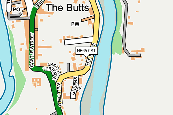
NE65 0ST is located in the Amble West with Warkworth electoral ward, within the unitary authority of Northumberland and the English Parliamentary constituency of Berwick-upon-Tweed. The Sub Integrated Care Board (ICB) Location is NHS North East and North Cumbria ICB - 00L and the police force is Northumbria. This postcode has been in use since January 1980.


GetTheData
Source: OS OpenMap – Local (Ordnance Survey)
Source: OS VectorMap District (Ordnance Survey)
Licence: Open Government Licence (requires attribution)
| Easting | 424898 |
| Northing | 605902 |
| Latitude | 55.346522 |
| Longitude | -1.608946 |
GetTheData
Source: Open Postcode Geo
Licence: Open Government Licence
| Country | England |
| Postcode District | NE65 |
➜ See where NE65 is on a map ➜ Where is Warkworth? | |
GetTheData
Source: Land Registry Price Paid Data
Licence: Open Government Licence
Elevation or altitude of NE65 0ST as distance above sea level:
| Metres | Feet | |
|---|---|---|
| Elevation | 10m | 33ft |
Elevation is measured from the approximate centre of the postcode, to the nearest point on an OS contour line from OS Terrain 50, which has contour spacing of ten vertical metres.
➜ How high above sea level am I? Find the elevation of your current position using your device's GPS.
GetTheData
Source: Open Postcode Elevation
Licence: Open Government Licence
| Ward | Amble West With Warkworth |
| Constituency | Berwick-upon-tweed |
GetTheData
Source: ONS Postcode Database
Licence: Open Government Licence
| Market Place (Castle Street) | Warkworth | 222m |
| Market Place (Dial Place) | Warkworth | 240m |
| Beal Bank Top (Woodlands) | Warkworth | 290m |
| Beal Bank Top (Beal Bank) | Warkworth | 328m |
| Coquet Bridge (A1068) | Warkworth | 430m |
| Acklington Station | 5.2km |
GetTheData
Source: NaPTAN
Licence: Open Government Licence
GetTheData
Source: ONS Postcode Database
Licence: Open Government Licence


➜ Get more ratings from the Food Standards Agency
GetTheData
Source: Food Standards Agency
Licence: FSA terms & conditions
| Last Collection | |||
|---|---|---|---|
| Location | Mon-Fri | Sat | Distance |
| Warkworth Post Office | 16:15 | 09:00 | 264m |
| Station Road | 16:00 | 09:00 | 553m |
| Watershaugh Road | 16:00 | 09:00 | 1,016m |
GetTheData
Source: Dracos
Licence: Creative Commons Attribution-ShareAlike
| Risk of NE65 0ST flooding from rivers and sea | Low |
| ➜ NE65 0ST flood map | |
GetTheData
Source: Open Flood Risk by Postcode
Licence: Open Government Licence
The below table lists the International Territorial Level (ITL) codes (formerly Nomenclature of Territorial Units for Statistics (NUTS) codes) and Local Administrative Units (LAU) codes for NE65 0ST:
| ITL 1 Code | Name |
|---|---|
| TLC | North East (England) |
| ITL 2 Code | Name |
| TLC2 | Northumberland, and Tyne and Wear |
| ITL 3 Code | Name |
| TLC21 | Northumberland |
| LAU 1 Code | Name |
| E06000057 | Northumberland |
GetTheData
Source: ONS Postcode Directory
Licence: Open Government Licence
The below table lists the Census Output Area (OA), Lower Layer Super Output Area (LSOA), and Middle Layer Super Output Area (MSOA) for NE65 0ST:
| Code | Name | |
|---|---|---|
| OA | E00139287 | |
| LSOA | E01027372 | Northumberland 006G |
| MSOA | E02005704 | Northumberland 006 |
GetTheData
Source: ONS Postcode Directory
Licence: Open Government Licence
| NE65 0SS | The Butts | 25m |
| NE65 0BF | Ceowulph Close | 46m |
| NE65 0SU | Wellfield | 61m |
| NE65 0GY | Greens Park | 120m |
| NE65 0UP | Castle Terrace | 136m |
| NE65 0SR | Elm Grove | 160m |
| NE65 0UN | Castle Street | 177m |
| NE65 0SN | Old Helsay | 177m |
| NE65 0UW | Castle Street | 209m |
| NE65 0UL | Castle Street | 215m |
GetTheData
Source: Open Postcode Geo; Land Registry Price Paid Data
Licence: Open Government Licence