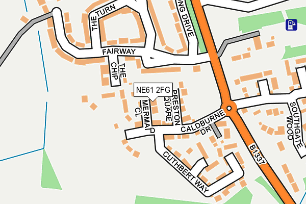
NE61 2FG is located in the Morpeth Kirkhill electoral ward, within the unitary authority of Northumberland and the English Parliamentary constituency of Wansbeck. The Sub Integrated Care Board (ICB) Location is NHS North East and North Cumbria ICB - 00L and the police force is Northumbria. This postcode has been in use since July 2017.


GetTheData
Source: OS OpenMap – Local (Ordnance Survey)
Source: OS VectorMap District (Ordnance Survey)
Licence: Open Government Licence (requires attribution)
| Easting | 419806 |
| Northing | 584239 |
| Latitude | 55.152101 |
| Longitude | -1.690764 |
GetTheData
Source: Open Postcode Geo
Licence: Open Government Licence
| Country | England |
| Postcode District | NE61 |
➜ See where NE61 is on a map | |
GetTheData
Source: Land Registry Price Paid Data
Licence: Open Government Licence
| Ward | Morpeth Kirkhill |
| Constituency | Wansbeck |
GetTheData
Source: ONS Postcode Database
Licence: Open Government Licence
| The Fairway (A197) | Loansdean | 175m |
| The Fairway (A197) | Loansdean | 178m |
| Catchburn Farm (A197) | Loansdean | 216m |
| Catchburn Farm (A197) | Loansdean | 417m |
| The Kylins (A197) | Loansdean | 445m |
| Morpeth Station | 1.2km |
| Pegswood Station | 4.1km |
GetTheData
Source: NaPTAN
Licence: Open Government Licence
| Percentage of properties with Next Generation Access | 100.0% |
| Percentage of properties with Superfast Broadband | 100.0% |
| Percentage of properties with Ultrafast Broadband | 0.0% |
| Percentage of properties with Full Fibre Broadband | 0.0% |
Superfast Broadband is between 30Mbps and 300Mbps
Ultrafast Broadband is > 300Mbps
| Median download speed | 40.0Mbps |
| Average download speed | 43.8Mbps |
| Maximum download speed | 80.00Mbps |
| Median upload speed | 10.0Mbps |
| Average upload speed | 10.8Mbps |
| Maximum upload speed | 20.00Mbps |
| Percentage of properties unable to receive 2Mbps | 0.0% |
| Percentage of properties unable to receive 5Mbps | 0.0% |
| Percentage of properties unable to receive 10Mbps | 0.0% |
| Percentage of properties unable to receive 30Mbps | 0.0% |
GetTheData
Source: Ofcom
Licence: Ofcom Terms of Use (requires attribution)
GetTheData
Source: ONS Postcode Database
Licence: Open Government Licence


➜ Get more ratings from the Food Standards Agency
GetTheData
Source: Food Standards Agency
Licence: FSA terms & conditions
| Last Collection | |||
|---|---|---|---|
| Location | Mon-Fri | Sat | Distance |
| Tranwell | 16:00 | 11:00 | 1,128m |
| Railway Station | 17:30 | 11:45 | 1,250m |
| Green Lane | 16:45 | 12:00 | 1,527m |
GetTheData
Source: Dracos
Licence: Creative Commons Attribution-ShareAlike
The below table lists the International Territorial Level (ITL) codes (formerly Nomenclature of Territorial Units for Statistics (NUTS) codes) and Local Administrative Units (LAU) codes for NE61 2FG:
| ITL 1 Code | Name |
|---|---|
| TLC | North East (England) |
| ITL 2 Code | Name |
| TLC2 | Northumberland, and Tyne and Wear |
| ITL 3 Code | Name |
| TLC21 | Northumberland |
| LAU 1 Code | Name |
| E06000057 | Northumberland |
GetTheData
Source: ONS Postcode Directory
Licence: Open Government Licence
The below table lists the Census Output Area (OA), Lower Layer Super Output Area (LSOA), and Middle Layer Super Output Area (MSOA) for NE61 2FG:
| Code | Name | |
|---|---|---|
| OA | E00139754 | |
| LSOA | E01027458 | Northumberland 018C |
| MSOA | E02005724 | Northumberland 018 |
GetTheData
Source: ONS Postcode Directory
Licence: Open Government Licence
| NE61 2DR | The Chip | 59m |
| NE61 2DW | The Fairway | 76m |
| NE61 2DN | Long Drive | 181m |
| NE61 2DS | The Fairway | 182m |
| NE61 2DU | The Turn | 182m |
| NE61 2EB | Southgate Wood | 203m |
| NE61 2DX | Somersby Wood | 225m |
| NE61 2DF | The Avenue | 250m |
| NE61 2BW | Southgate Mews | 266m |
| NE61 2DT | 282m |
GetTheData
Source: Open Postcode Geo; Land Registry Price Paid Data
Licence: Open Government Licence