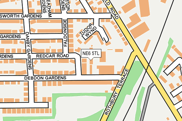
NE6 5TL is located in the Heaton electoral ward, within the metropolitan district of Newcastle upon Tyne and the English Parliamentary constituency of Newcastle upon Tyne East. The Sub Integrated Care Board (ICB) Location is NHS North East and North Cumbria ICB - 13T and the police force is Northumbria. This postcode has been in use since January 1980.


GetTheData
Source: OS OpenMap – Local (Ordnance Survey)
Source: OS VectorMap District (Ordnance Survey)
Licence: Open Government Licence (requires attribution)
| Easting | 427869 |
| Northing | 566436 |
| Latitude | 54.991736 |
| Longitude | -1.565966 |
GetTheData
Source: Open Postcode Geo
Licence: Open Government Licence
| Country | England |
| Postcode District | NE6 |
➜ See where NE6 is on a map ➜ Where is Newcastle upon Tyne? | |
GetTheData
Source: Land Registry Price Paid Data
Licence: Open Government Licence
Elevation or altitude of NE6 5TL as distance above sea level:
| Metres | Feet | |
|---|---|---|
| Elevation | 40m | 131ft |
Elevation is measured from the approximate centre of the postcode, to the nearest point on an OS contour line from OS Terrain 50, which has contour spacing of ten vertical metres.
➜ How high above sea level am I? Find the elevation of your current position using your device's GPS.
GetTheData
Source: Open Postcode Elevation
Licence: Open Government Licence
| Ward | Heaton |
| Constituency | Newcastle Upon Tyne East |
GetTheData
Source: ONS Postcode Database
Licence: Open Government Licence
| Rothbury Terrace | Heaton | 123m |
| Rothbury Terrace | Heaton | 125m |
| Benfield Road-bosworth Gardens (Benfield Road) | Heaton | 148m |
| Benfield Road-rothbury Terrace (Benfield Road) | Heaton | 152m |
| Debdon Gardens | Heaton | 163m |
| Walkergate (Tyne And Wear Metro Station) (Benfield Road) | Walkergate | 824m |
| Chillingham Road (Tyne And Wear Metro Station) (Depot Road) | Heaton | 1,057m |
| Manors Station | 3.3km |
| Newcastle Station | 4.2km |
| Heworth Station | 4.5km |
GetTheData
Source: NaPTAN
Licence: Open Government Licence
GetTheData
Source: ONS Postcode Database
Licence: Open Government Licence


➜ Get more ratings from the Food Standards Agency
GetTheData
Source: Food Standards Agency
Licence: FSA terms & conditions
| Last Collection | |||
|---|---|---|---|
| Location | Mon-Fri | Sat | Distance |
| Industry Road | 229m | ||
| Benfield Road Post Office | 17:45 | 12:00 | 263m |
| Sackville Road | 17:30 | 12:00 | 362m |
GetTheData
Source: Dracos
Licence: Creative Commons Attribution-ShareAlike
The below table lists the International Territorial Level (ITL) codes (formerly Nomenclature of Territorial Units for Statistics (NUTS) codes) and Local Administrative Units (LAU) codes for NE6 5TL:
| ITL 1 Code | Name |
|---|---|
| TLC | North East (England) |
| ITL 2 Code | Name |
| TLC2 | Northumberland, and Tyne and Wear |
| ITL 3 Code | Name |
| TLC22 | Tyneside |
| LAU 1 Code | Name |
| E08000021 | Newcastle upon Tyne |
GetTheData
Source: ONS Postcode Directory
Licence: Open Government Licence
The below table lists the Census Output Area (OA), Lower Layer Super Output Area (LSOA), and Middle Layer Super Output Area (MSOA) for NE6 5TL:
| Code | Name | |
|---|---|---|
| OA | E00042403 | |
| LSOA | E01008363 | Newcastle upon Tyne 012E |
| MSOA | E02001719 | Newcastle upon Tyne 012 |
GetTheData
Source: ONS Postcode Directory
Licence: Open Government Licence
| NE6 5UE | Redcar Road | 86m |
| NE6 5UU | Tudor Wynd | 92m |
| NE6 5TS | Debdon Gardens | 99m |
| NE6 5UH | Faldonside | 110m |
| NE6 5UY | Benfield Road | 132m |
| NE6 5UP | Bosworth Gardens | 173m |
| NE6 5UL | Craythorne Gardens | 174m |
| NE6 5TH | Danby Gardens | 187m |
| NE6 5XA | Benfield Road | 194m |
| NE6 5UT | Allerton Gardens | 225m |
GetTheData
Source: Open Postcode Geo; Land Registry Price Paid Data
Licence: Open Government Licence