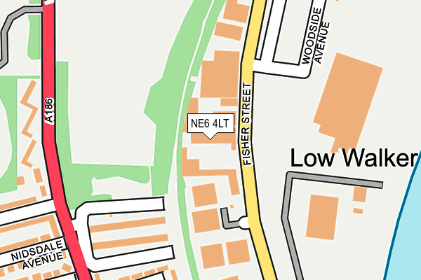
NE6 4LT lies on Fisher Street in Newcastle Upon Tyne. NE6 4LT is located in the Walkergate electoral ward, within the metropolitan district of Newcastle upon Tyne and the English Parliamentary constituency of Newcastle upon Tyne East. The Sub Integrated Care Board (ICB) Location is NHS North East and North Cumbria ICB - 13T and the police force is Northumbria. This postcode has been in use since January 1980.


GetTheData
Source: OS OpenMap – Local (Ordnance Survey)
Source: OS VectorMap District (Ordnance Survey)
Licence: Open Government Licence (requires attribution)
| Easting | 429632 |
| Northing | 565204 |
| Latitude | 54.980564 |
| Longitude | -1.538540 |
GetTheData
Source: Open Postcode Geo
Licence: Open Government Licence
| Street | Fisher Street |
| Town/City | Newcastle Upon Tyne |
| Country | England |
| Postcode District | NE6 |
➜ See where NE6 is on a map ➜ Where is Newcastle upon Tyne? | |
GetTheData
Source: Land Registry Price Paid Data
Licence: Open Government Licence
Elevation or altitude of NE6 4LT as distance above sea level:
| Metres | Feet | |
|---|---|---|
| Elevation | 20m | 66ft |
Elevation is measured from the approximate centre of the postcode, to the nearest point on an OS contour line from OS Terrain 50, which has contour spacing of ten vertical metres.
➜ How high above sea level am I? Find the elevation of your current position using your device's GPS.
GetTheData
Source: Open Postcode Elevation
Licence: Open Government Licence
| Ward | Walkergate |
| Constituency | Newcastle Upon Tyne East |
GetTheData
Source: ONS Postcode Database
Licence: Open Government Licence
| Fisher Street-depot (Fisher Street) | Low Walker | 46m |
| Fisher Street-depot (Fisher Street) | Low Walker | 131m |
| Fisher Street-industrial Estate (Fisher Street) | Low Walker | 208m |
| Fisher Street-industrial Estate (Fisher Street) | Low Walker | 209m |
| Waverdale Avenue-ennerdale Road (Waverdale Avenue) | Walker | 227m |
| Wallsend (Tyne And Wear Metro Station) (Station Road) | Wallsend | 1,082m |
| Hebburn (Tyne And Wear Metro Station) (Prince Consort Road) | Hebburn | 1,280m |
| Walkergate (Tyne And Wear Metro Station) (Benfield Road) | Walkergate | 1,423m |
| Hadrian Road (Tyne And Wear Metro Station) (Hadrian Road) | Hadrian Road | 1,945m |
| Heworth Station | 3.4km |
| Manors Station | 4.3km |
| Brockley Whins Station | 5.5km |
GetTheData
Source: NaPTAN
Licence: Open Government Licence
Estimated total energy consumption in NE6 4LT by fuel type, 2015.
| Consumption (kWh) | 154,639 |
|---|---|
| Meter count | 6 |
| Mean (kWh/meter) | 25,773 |
| Median (kWh/meter) | 23,880 |
GetTheData
Source: Postcode level gas estimates: 2015 (experimental)
Source: Postcode level electricity estimates: 2015 (experimental)
Licence: Open Government Licence
GetTheData
Source: ONS Postcode Database
Licence: Open Government Licence

➜ Get more ratings from the Food Standards Agency
GetTheData
Source: Food Standards Agency
Licence: FSA terms & conditions
| Last Collection | |||
|---|---|---|---|
| Location | Mon-Fri | Sat | Distance |
| Walker Post Office | 17:00 | 12:15 | 909m |
| Albert Street | 17:00 | 10:30 | 1,016m |
| Walkerville Post Office | 17:30 | 12:00 | 1,016m |
GetTheData
Source: Dracos
Licence: Creative Commons Attribution-ShareAlike
The below table lists the International Territorial Level (ITL) codes (formerly Nomenclature of Territorial Units for Statistics (NUTS) codes) and Local Administrative Units (LAU) codes for NE6 4LT:
| ITL 1 Code | Name |
|---|---|
| TLC | North East (England) |
| ITL 2 Code | Name |
| TLC2 | Northumberland, and Tyne and Wear |
| ITL 3 Code | Name |
| TLC22 | Tyneside |
| LAU 1 Code | Name |
| E08000021 | Newcastle upon Tyne |
GetTheData
Source: ONS Postcode Directory
Licence: Open Government Licence
The below table lists the Census Output Area (OA), Lower Layer Super Output Area (LSOA), and Middle Layer Super Output Area (MSOA) for NE6 4LT:
| Code | Name | |
|---|---|---|
| OA | E00042793 | |
| LSOA | E01008436 | Newcastle upon Tyne 020F |
| MSOA | E02001727 | Newcastle upon Tyne 020 |
GetTheData
Source: ONS Postcode Directory
Licence: Open Government Licence
| NE6 4LL | Abbeyvale Drive | 186m |
| NE6 4LA | Waverdale Avenue | 258m |
| NE6 4JY | Waverdale Avenue | 269m |
| NE6 4LR | Westerdale Place | 281m |
| NE6 4JX | Waverdale Avenue | 317m |
| NE6 4LN | Nidsdale Avenue | 328m |
| NE6 4LP | Coquetdale Avenue | 346m |
| NE6 4LJ | Ennerdale Road | 347m |
| NE6 4LH | Blackwell Avenue | 368m |
| NE6 4LB | Edendale Avenue | 405m |
GetTheData
Source: Open Postcode Geo; Land Registry Price Paid Data
Licence: Open Government Licence