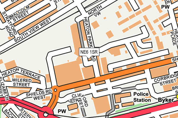
NE6 1SR is located in the Byker electoral ward, within the metropolitan district of Newcastle upon Tyne and the English Parliamentary constituency of Newcastle upon Tyne East. The Sub Integrated Care Board (ICB) Location is NHS North East and North Cumbria ICB - 13T and the police force is Northumbria. This postcode has been in use since August 2006.


GetTheData
Source: OS OpenMap – Local (Ordnance Survey)
Source: OS VectorMap District (Ordnance Survey)
Licence: Open Government Licence (requires attribution)
| Easting | 426673 |
| Northing | 564815 |
| Latitude | 54.977235 |
| Longitude | -1.584808 |
GetTheData
Source: Open Postcode Geo
Licence: Open Government Licence
| Country | England |
| Postcode District | NE6 |
➜ See where NE6 is on a map ➜ Where is Newcastle upon Tyne? | |
GetTheData
Source: Land Registry Price Paid Data
Licence: Open Government Licence
Elevation or altitude of NE6 1SR as distance above sea level:
| Metres | Feet | |
|---|---|---|
| Elevation | 40m | 131ft |
Elevation is measured from the approximate centre of the postcode, to the nearest point on an OS contour line from OS Terrain 50, which has contour spacing of ten vertical metres.
➜ How high above sea level am I? Find the elevation of your current position using your device's GPS.
GetTheData
Source: Open Postcode Elevation
Licence: Open Government Licence
| Ward | Byker |
| Constituency | Newcastle Upon Tyne East |
GetTheData
Source: ONS Postcode Database
Licence: Open Government Licence
| Heaton Park Road-shields Road (Heaton Park Road) | Byker | 24m |
| Heaton Park Road-shields Road (Heaton Park Road) | Byker | 27m |
| Shields Road-heaton Park Road (Shields Road) | Byker | 74m |
| Shields Road - Morrisons (Shields Road) | Byker | 112m |
| Shields Road - Grafton Street (Shields Road) | Byker | 133m |
| Byker (Tyne And Wear Metro Station) (Byker Bridge) | Byker | 358m |
| Chillingham Road (Tyne And Wear Metro Station) (Depot Road) | Heaton | 1,046m |
| Manors (Tyne And Wear Metro Station) (Argyll Street) | Manors | 1,330m |
| Jesmond (Tyne And Wear Metro Station) (Eslington Road) | Jesmond | 1,473m |
| Manors Station | 1.4km |
| Newcastle Station | 2.3km |
| Heworth Station | 3.4km |
GetTheData
Source: NaPTAN
Licence: Open Government Licence
GetTheData
Source: ONS Postcode Database
Licence: Open Government Licence


➜ Get more ratings from the Food Standards Agency
GetTheData
Source: Food Standards Agency
Licence: FSA terms & conditions
| Last Collection | |||
|---|---|---|---|
| Location | Mon-Fri | Sat | Distance |
| Snax 24 Garage | 18:15 | 12:15 | 212m |
| Shields Road | 18:30 | 12:15 | 336m |
| St Lawrence Road | 18:30 | 12:30 | 577m |
GetTheData
Source: Dracos
Licence: Creative Commons Attribution-ShareAlike
The below table lists the International Territorial Level (ITL) codes (formerly Nomenclature of Territorial Units for Statistics (NUTS) codes) and Local Administrative Units (LAU) codes for NE6 1SR:
| ITL 1 Code | Name |
|---|---|
| TLC | North East (England) |
| ITL 2 Code | Name |
| TLC2 | Northumberland, and Tyne and Wear |
| ITL 3 Code | Name |
| TLC22 | Tyneside |
| LAU 1 Code | Name |
| E08000021 | Newcastle upon Tyne |
GetTheData
Source: ONS Postcode Directory
Licence: Open Government Licence
The below table lists the Census Output Area (OA), Lower Layer Super Output Area (LSOA), and Middle Layer Super Output Area (MSOA) for NE6 1SR:
| Code | Name | |
|---|---|---|
| OA | E00042125 | |
| LSOA | E01008304 | Newcastle upon Tyne 026C |
| MSOA | E02001733 | Newcastle upon Tyne 026 |
GetTheData
Source: ONS Postcode Directory
Licence: Open Government Licence
| NE6 1SQ | Heaton Park Road | 14m |
| NE6 1DR | Shields Road | 95m |
| NE6 1DL | Shields Road | 113m |
| NE6 1DS | Shields Road | 138m |
| NE6 1XW | Molineux Close | 172m |
| NE6 1XN | Molineux Close | 183m |
| NE6 1XB | Grafton Close | 183m |
| NE6 1JN | Shields Road West | 201m |
| NE6 5PP | South View West | 214m |
| NE6 1XJ | Langhorn Close | 221m |
GetTheData
Source: Open Postcode Geo; Land Registry Price Paid Data
Licence: Open Government Licence