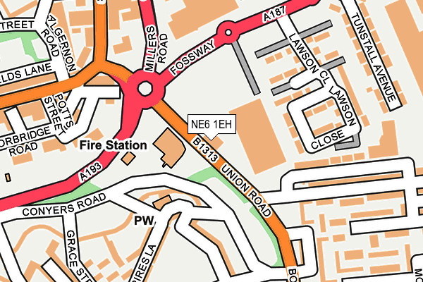
NE6 1EH lies on Union Road in Newcastle Upon Tyne. NE6 1EH is located in the Byker electoral ward, within the metropolitan district of Newcastle upon Tyne and the English Parliamentary constituency of Newcastle upon Tyne East. The Sub Integrated Care Board (ICB) Location is NHS North East and North Cumbria ICB - 13T and the police force is Northumbria. This postcode has been in use since January 1980.


GetTheData
Source: OS OpenMap – Local (Ordnance Survey)
Source: OS VectorMap District (Ordnance Survey)
Licence: Open Government Licence (requires attribution)
| Easting | 427459 |
| Northing | 564807 |
| Latitude | 54.977121 |
| Longitude | -1.572529 |
GetTheData
Source: Open Postcode Geo
Licence: Open Government Licence
| Street | Union Road |
| Town/City | Newcastle Upon Tyne |
| Country | England |
| Postcode District | NE6 |
➜ See where NE6 is on a map ➜ Where is Newcastle upon Tyne? | |
GetTheData
Source: Land Registry Price Paid Data
Licence: Open Government Licence
Elevation or altitude of NE6 1EH as distance above sea level:
| Metres | Feet | |
|---|---|---|
| Elevation | 60m | 197ft |
Elevation is measured from the approximate centre of the postcode, to the nearest point on an OS contour line from OS Terrain 50, which has contour spacing of ten vertical metres.
➜ How high above sea level am I? Find the elevation of your current position using your device's GPS.
GetTheData
Source: Open Postcode Elevation
Licence: Open Government Licence
| Ward | Byker |
| Constituency | Newcastle Upon Tyne East |
GetTheData
Source: ONS Postcode Database
Licence: Open Government Licence
| Union Road | Byker | 49m |
| Union Road (Union Road) | Byker | 71m |
| Bothal Street (Union Road) | Byker | 140m |
| Fossway | Byker | 222m |
| Fossway-tunstall Avenue (Fossway) | Byker | 235m |
| Byker (Tyne And Wear Metro Station) (Byker Bridge) | Byker | 463m |
| Chillingham Road (Tyne And Wear Metro Station) (Depot Road) | Heaton | 637m |
| Walkergate (Tyne And Wear Metro Station) (Benfield Road) | Walkergate | 1,268m |
| Manors Station | 2.1km |
| Newcastle Station | 3km |
| Heworth Station | 3km |
GetTheData
Source: NaPTAN
Licence: Open Government Licence
GetTheData
Source: ONS Postcode Database
Licence: Open Government Licence


➜ Get more ratings from the Food Standards Agency
GetTheData
Source: Food Standards Agency
Licence: FSA terms & conditions
| Last Collection | |||
|---|---|---|---|
| Location | Mon-Fri | Sat | Distance |
| Shields Road | 18:30 | 12:15 | 454m |
| St Lawrence Road | 18:30 | 12:30 | 647m |
| Byker Post Office | 18:30 | 12:00 | 658m |
GetTheData
Source: Dracos
Licence: Creative Commons Attribution-ShareAlike
The below table lists the International Territorial Level (ITL) codes (formerly Nomenclature of Territorial Units for Statistics (NUTS) codes) and Local Administrative Units (LAU) codes for NE6 1EH:
| ITL 1 Code | Name |
|---|---|
| TLC | North East (England) |
| ITL 2 Code | Name |
| TLC2 | Northumberland, and Tyne and Wear |
| ITL 3 Code | Name |
| TLC22 | Tyneside |
| LAU 1 Code | Name |
| E08000021 | Newcastle upon Tyne |
GetTheData
Source: ONS Postcode Directory
Licence: Open Government Licence
The below table lists the Census Output Area (OA), Lower Layer Super Output Area (LSOA), and Middle Layer Super Output Area (MSOA) for NE6 1EH:
| Code | Name | |
|---|---|---|
| OA | E00042556 | |
| LSOA | E01008392 | Newcastle upon Tyne 026F |
| MSOA | E02001733 | Newcastle upon Tyne 026 |
GetTheData
Source: ONS Postcode Directory
Licence: Open Government Licence
| NE6 2UL | Lawson Close | 133m |
| NE6 2EW | Felton Walk | 172m |
| NE6 2JY | Winship Terrace | 174m |
| NE6 1PB | Glendale Terrace | 194m |
| NE6 2US | Lawson Close | 205m |
| NE6 2NT | Spires Lane | 209m |
| NE6 2RR | Grace Street | 210m |
| NE6 2NW | 212m | |
| NE6 2RT | Scarborough Road | 219m |
| NE6 2LW | Felton Green | 243m |
GetTheData
Source: Open Postcode Geo; Land Registry Price Paid Data
Licence: Open Government Licence