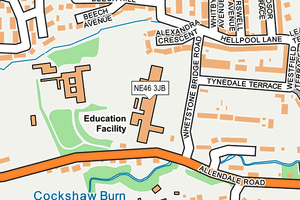
NE46 3JB is located in the Hexham West electoral ward, within the unitary authority of Northumberland and the English Parliamentary constituency of Hexham. The Sub Integrated Care Board (ICB) Location is NHS North East and North Cumbria ICB - 00L and the police force is Northumbria. This postcode has been in use since January 1980.


GetTheData
Source: OS OpenMap – Local (Ordnance Survey)
Source: OS VectorMap District (Ordnance Survey)
Licence: Open Government Licence (requires attribution)
| Easting | 392378 |
| Northing | 563944 |
| Latitude | 54.970062 |
| Longitude | -2.120601 |
GetTheData
Source: Open Postcode Geo
Licence: Open Government Licence
| Country | England |
| Postcode District | NE46 |
➜ See where NE46 is on a map ➜ Where is Hexham? | |
GetTheData
Source: Land Registry Price Paid Data
Licence: Open Government Licence
Elevation or altitude of NE46 3JB as distance above sea level:
| Metres | Feet | |
|---|---|---|
| Elevation | 80m | 262ft |
Elevation is measured from the approximate centre of the postcode, to the nearest point on an OS contour line from OS Terrain 50, which has contour spacing of ten vertical metres.
➜ How high above sea level am I? Find the elevation of your current position using your device's GPS.
GetTheData
Source: Open Postcode Elevation
Licence: Open Government Licence
| Ward | Hexham West |
| Constituency | Hexham |
GetTheData
Source: ONS Postcode Database
Licence: Open Government Licence
| Queen Elizabeth High School Hydro (Allendale Road) | Leazes | 14m |
| Whetstone Bridge Road | Leazes | 259m |
| Whetstone Bridge Road | Leazes | 265m |
| Allendale Road (B6305) | Leazes | 290m |
| Allendale Road | Leazes | 290m |
| Hexham Station | 1.7km |
GetTheData
Source: NaPTAN
Licence: Open Government Licence
GetTheData
Source: ONS Postcode Database
Licence: Open Government Licence


➜ Get more ratings from the Food Standards Agency
GetTheData
Source: Food Standards Agency
Licence: FSA terms & conditions
| Last Collection | |||
|---|---|---|---|
| Location | Mon-Fri | Sat | Distance |
| Allendale Road | 17:30 | 12:00 | 115m |
| Beech Hill | 16:30 | 12:15 | 301m |
| Leazes Lane | 16:30 | 12:00 | 444m |
GetTheData
Source: Dracos
Licence: Creative Commons Attribution-ShareAlike
The below table lists the International Territorial Level (ITL) codes (formerly Nomenclature of Territorial Units for Statistics (NUTS) codes) and Local Administrative Units (LAU) codes for NE46 3JB:
| ITL 1 Code | Name |
|---|---|
| TLC | North East (England) |
| ITL 2 Code | Name |
| TLC2 | Northumberland, and Tyne and Wear |
| ITL 3 Code | Name |
| TLC21 | Northumberland |
| LAU 1 Code | Name |
| E06000057 | Northumberland |
GetTheData
Source: ONS Postcode Directory
Licence: Open Government Licence
The below table lists the Census Output Area (OA), Lower Layer Super Output Area (LSOA), and Middle Layer Super Output Area (MSOA) for NE46 3JB:
| Code | Name | |
|---|---|---|
| OA | E00139925 | |
| LSOA | E01027492 | Northumberland 035E |
| MSOA | E02005730 | Northumberland 035 |
GetTheData
Source: ONS Postcode Directory
Licence: Open Government Licence
| NE46 3AF | Beech Avenue | 178m |
| NE46 2NB | Allendale Road | 202m |
| NE46 3AX | Leazes Park | 219m |
| NE46 3AY | Leazes Park | 226m |
| NE46 3AG | Beech Hill | 246m |
| NE46 3AA | Alexandra Crescent | 257m |
| NE46 3JD | Whetstone Bridge Road | 282m |
| NE46 2DS | Whetstone Green | 307m |
| NE46 3AB | Low Burswell | 317m |
| NE46 2DD | Highford Lane | 325m |
GetTheData
Source: Open Postcode Geo; Land Registry Price Paid Data
Licence: Open Government Licence