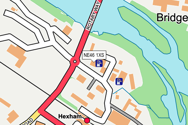
NE46 1XS is located in the Hexham East electoral ward, within the unitary authority of Northumberland and the English Parliamentary constituency of Hexham. The Sub Integrated Care Board (ICB) Location is NHS North East and North Cumbria ICB - 00L and the police force is Northumbria. This postcode has been in use since January 1980.


GetTheData
Source: OS OpenMap – Local (Ordnance Survey)
Source: OS VectorMap District (Ordnance Survey)
Licence: Open Government Licence (requires attribution)
| Easting | 394064 |
| Northing | 564506 |
| Latitude | 54.975129 |
| Longitude | -2.094267 |
GetTheData
Source: Open Postcode Geo
Licence: Open Government Licence
| Country | England |
| Postcode District | NE46 |
➜ See where NE46 is on a map ➜ Where is Hexham? | |
GetTheData
Source: Land Registry Price Paid Data
Licence: Open Government Licence
Elevation or altitude of NE46 1XS as distance above sea level:
| Metres | Feet | |
|---|---|---|
| Elevation | 30m | 98ft |
Elevation is measured from the approximate centre of the postcode, to the nearest point on an OS contour line from OS Terrain 50, which has contour spacing of ten vertical metres.
➜ How high above sea level am I? Find the elevation of your current position using your device's GPS.
GetTheData
Source: Open Postcode Elevation
Licence: Open Government Licence
| Ward | Hexham East |
| Constituency | Hexham |
GetTheData
Source: ONS Postcode Database
Licence: Open Government Licence
| Railway Station (Station Road) | Hexham | 238m |
| Railway Station (Station Road) | Hexham | 245m |
| Railway Station (Station Road) | Hexham | 303m |
| Wentworth Car Park (Car Park) | Hexham | 390m |
| Aldi (Haugh Lane Industrial Estate) | Hexham | 479m |
| Hexham Station | 0.2km |
| Corbridge Station | 5km |
GetTheData
Source: NaPTAN
Licence: Open Government Licence
GetTheData
Source: ONS Postcode Database
Licence: Open Government Licence


➜ Get more ratings from the Food Standards Agency
GetTheData
Source: Food Standards Agency
Licence: FSA terms & conditions
| Last Collection | |||
|---|---|---|---|
| Location | Mon-Fri | Sat | Distance |
| Tyne Mills Industrial Estate | 18:00 | 12:00 | 54m |
| Railway Station | 17:15 | 12:00 | 207m |
| Bridge End Cottage | 17:15 | 11:40 | 383m |
GetTheData
Source: Dracos
Licence: Creative Commons Attribution-ShareAlike
| Risk of NE46 1XS flooding from rivers and sea | Low |
| ➜ NE46 1XS flood map | |
GetTheData
Source: Open Flood Risk by Postcode
Licence: Open Government Licence
The below table lists the International Territorial Level (ITL) codes (formerly Nomenclature of Territorial Units for Statistics (NUTS) codes) and Local Administrative Units (LAU) codes for NE46 1XS:
| ITL 1 Code | Name |
|---|---|
| TLC | North East (England) |
| ITL 2 Code | Name |
| TLC2 | Northumberland, and Tyne and Wear |
| ITL 3 Code | Name |
| TLC21 | Northumberland |
| LAU 1 Code | Name |
| E06000057 | Northumberland |
GetTheData
Source: ONS Postcode Directory
Licence: Open Government Licence
The below table lists the Census Output Area (OA), Lower Layer Super Output Area (LSOA), and Middle Layer Super Output Area (MSOA) for NE46 1XS:
| Code | Name | |
|---|---|---|
| OA | E00139938 | |
| LSOA | E01027494 | Northumberland 035G |
| MSOA | E02005730 | Northumberland 035 |
GetTheData
Source: ONS Postcode Directory
Licence: Open Government Licence
| NE46 1XL | Tyne Mills | 99m |
| NE46 1HD | Sawmill Cottages | 350m |
| NE46 4JW | Ferry Road | 361m |
| NE46 3PJ | Alemouth Road | 400m |
| NE46 3PH | Hallstile Cottages | 424m |
| NE46 1HE | Hollow Meadows | 426m |
| NE46 1HG | Dean Street | 441m |
| NE46 1QL | Chisholm Place | 450m |
| NE46 1HQ | Peth Head | 483m |
| NE46 3PQ | Hallstile Bank | 487m |
GetTheData
Source: Open Postcode Geo; Land Registry Price Paid Data
Licence: Open Government Licence