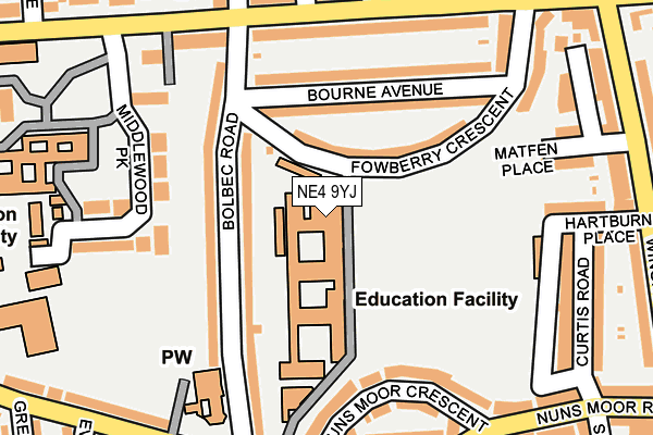
NE4 9YJ is located in the Wingrove electoral ward, within the metropolitan district of Newcastle upon Tyne and the English Parliamentary constituency of Newcastle upon Tyne Central. The Sub Integrated Care Board (ICB) Location is NHS North East and North Cumbria ICB - 13T and the police force is Northumbria. This postcode has been in use since January 1980.


GetTheData
Source: OS OpenMap – Local (Ordnance Survey)
Source: OS VectorMap District (Ordnance Survey)
Licence: Open Government Licence (requires attribution)
| Easting | 422339 |
| Northing | 565354 |
| Latitude | 54.982291 |
| Longitude | -1.652477 |
GetTheData
Source: Open Postcode Geo
Licence: Open Government Licence
| Country | England |
| Postcode District | NE4 |
➜ See where NE4 is on a map ➜ Where is Newcastle upon Tyne? | |
GetTheData
Source: Land Registry Price Paid Data
Licence: Open Government Licence
Elevation or altitude of NE4 9YJ as distance above sea level:
| Metres | Feet | |
|---|---|---|
| Elevation | 110m | 361ft |
Elevation is measured from the approximate centre of the postcode, to the nearest point on an OS contour line from OS Terrain 50, which has contour spacing of ten vertical metres.
➜ How high above sea level am I? Find the elevation of your current position using your device's GPS.
GetTheData
Source: Open Postcode Elevation
Licence: Open Government Licence
| Ward | Wingrove |
| Constituency | Newcastle Upon Tyne Central |
GetTheData
Source: ONS Postcode Database
Licence: Open Government Licence
| Dame Allan's School (Fowberry Crescent) | Fenham | 34m |
| Fenham Hall Drive-simonburn Avenue (Fenham Hall Drive) | Fenham | 184m |
| Fenham Hall Drive-simonburn Avenue (Fenham Hall Drive) | Fenham | 197m |
| Fenham Hall Drive-kingsway (Fenham Hall Drive) | Fenham | 228m |
| Fenham Hall Drive-fowberry Crescent (Fenham Hall Drive) | Fenham | 244m |
| Newcastle Station | 2.7km |
| Metrocentre Station | 2.8km |
| Manors Station | 3.2km |
GetTheData
Source: NaPTAN
Licence: Open Government Licence
GetTheData
Source: ONS Postcode Database
Licence: Open Government Licence


➜ Get more ratings from the Food Standards Agency
GetTheData
Source: Food Standards Agency
Licence: FSA terms & conditions
| Last Collection | |||
|---|---|---|---|
| Location | Mon-Fri | Sat | Distance |
| Bolbec Road | 17:30 | 11:45 | 107m |
| Fenham Hall Drive | 17:30 | 12:15 | 198m |
| Severus Road | 17:45 | 12:00 | 345m |
GetTheData
Source: Dracos
Licence: Creative Commons Attribution-ShareAlike
The below table lists the International Territorial Level (ITL) codes (formerly Nomenclature of Territorial Units for Statistics (NUTS) codes) and Local Administrative Units (LAU) codes for NE4 9YJ:
| ITL 1 Code | Name |
|---|---|
| TLC | North East (England) |
| ITL 2 Code | Name |
| TLC2 | Northumberland, and Tyne and Wear |
| ITL 3 Code | Name |
| TLC22 | Tyneside |
| LAU 1 Code | Name |
| E08000021 | Newcastle upon Tyne |
GetTheData
Source: ONS Postcode Directory
Licence: Open Government Licence
The below table lists the Census Output Area (OA), Lower Layer Super Output Area (LSOA), and Middle Layer Super Output Area (MSOA) for NE4 9YJ:
| Code | Name | |
|---|---|---|
| OA | E00042893 | |
| LSOA | E01008453 | Newcastle upon Tyne 022E |
| MSOA | E02001729 | Newcastle upon Tyne 022 |
GetTheData
Source: ONS Postcode Directory
Licence: Open Government Licence
| NE4 9XJ | Fowberry Crescent | 81m |
| NE4 9EP | Bolbec Road | 91m |
| NE4 9XN | Bourne Avenue | 116m |
| NE4 9XL | Bourne Avenue | 141m |
| NE4 9EQ | Bolbec Road | 156m |
| NE4 9XF | Middlewood Park | 159m |
| NE4 9UX | Fenham Hall Drive | 171m |
| NE4 9BE | Nuns Moor Crescent | 182m |
| NE4 9XG | Middlewood Park | 206m |
| NE4 9UY | Fenham Hall Drive | 209m |
GetTheData
Source: Open Postcode Geo; Land Registry Price Paid Data
Licence: Open Government Licence