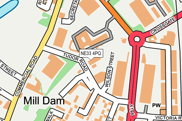
NE33 4PQ is located in the Beacon and Bents electoral ward, within the metropolitan district of South Tyneside and the English Parliamentary constituency of South Shields. The Sub Integrated Care Board (ICB) Location is NHS North East and North Cumbria ICB - 00N and the police force is Northumbria. This postcode has been in use since January 1993.


GetTheData
Source: OS OpenMap – Local (Ordnance Survey)
Source: OS VectorMap District (Ordnance Survey)
Licence: Open Government Licence (requires attribution)
| Easting | 436100 |
| Northing | 566570 |
| Latitude | 54.992414 |
| Longitude | -1.437313 |
GetTheData
Source: Open Postcode Geo
Licence: Open Government Licence
| Country | England |
| Postcode District | NE33 |
➜ See where NE33 is on a map ➜ Where is South Shields? | |
GetTheData
Source: Land Registry Price Paid Data
Licence: Open Government Licence
Elevation or altitude of NE33 4PQ as distance above sea level:
| Metres | Feet | |
|---|---|---|
| Elevation | 10m | 33ft |
Elevation is measured from the approximate centre of the postcode, to the nearest point on an OS contour line from OS Terrain 50, which has contour spacing of ten vertical metres.
➜ How high above sea level am I? Find the elevation of your current position using your device's GPS.
GetTheData
Source: Open Postcode Elevation
Licence: Open Government Licence
| Ward | Beacon And Bents |
| Constituency | South Shields |
GetTheData
Source: ONS Postcode Database
Licence: Open Government Licence
| Western Approach-tudor Road (Western Approach) | Laygate | 147m |
| Western Approach-victoria Road (Western Approach) | Laygate | 154m |
| Western Approach-victoria Road (Western Approach) | Laygate | 160m |
| Commercial Road-tudor Road (Commercial Road) | South Shields | 169m |
| Commercial Road-court (Commercial Road) | South Shields | 172m |
| South Shields (Tyne And Wear Metro Station) (Smithy Street) | South Shields | 713m |
| Chichester (Tyne And Wear Metro Station) (Laygate) | Chichester | 754m |
| Brockley Whins Station | 4km |
GetTheData
Source: NaPTAN
Licence: Open Government Licence
GetTheData
Source: ONS Postcode Database
Licence: Open Government Licence


➜ Get more ratings from the Food Standards Agency
GetTheData
Source: Food Standards Agency
Licence: FSA terms & conditions
| Last Collection | |||
|---|---|---|---|
| Location | Mon-Fri | Sat | Distance |
| Green Street Post Office | 17:30 | 10:30 | 331m |
| Mill Dam | 18:15 | 10:00 | 347m |
| Commercial Road | 17:15 | 10:00 | 435m |
GetTheData
Source: Dracos
Licence: Creative Commons Attribution-ShareAlike
The below table lists the International Territorial Level (ITL) codes (formerly Nomenclature of Territorial Units for Statistics (NUTS) codes) and Local Administrative Units (LAU) codes for NE33 4PQ:
| ITL 1 Code | Name |
|---|---|
| TLC | North East (England) |
| ITL 2 Code | Name |
| TLC2 | Northumberland, and Tyne and Wear |
| ITL 3 Code | Name |
| TLC22 | Tyneside |
| LAU 1 Code | Name |
| E08000023 | South Tyneside |
GetTheData
Source: ONS Postcode Directory
Licence: Open Government Licence
The below table lists the Census Output Area (OA), Lower Layer Super Output Area (LSOA), and Middle Layer Super Output Area (MSOA) for NE33 4PQ:
| Code | Name | |
|---|---|---|
| OA | E00044013 | |
| LSOA | E01008666 | South Tyneside 002C |
| MSOA | E02001769 | South Tyneside 002 |
GetTheData
Source: ONS Postcode Directory
Licence: Open Government Licence
| NE33 5RX | Regent Court | 126m |
| NE33 5RS | Bowman Place | 154m |
| NE33 5RE | Brunswick Street | 208m |
| NE33 5RT | Laygate Place | 216m |
| NE33 5DP | Western Approach | 218m |
| NE33 5RU | Trinity Walk | 219m |
| NE33 4PU | Maxwell Street | 245m |
| NE33 5DL | New Green Street | 260m |
| NE33 1EH | Riverside Court | 261m |
| NE33 5RF | Laygate | 307m |
GetTheData
Source: Open Postcode Geo; Land Registry Price Paid Data
Licence: Open Government Licence