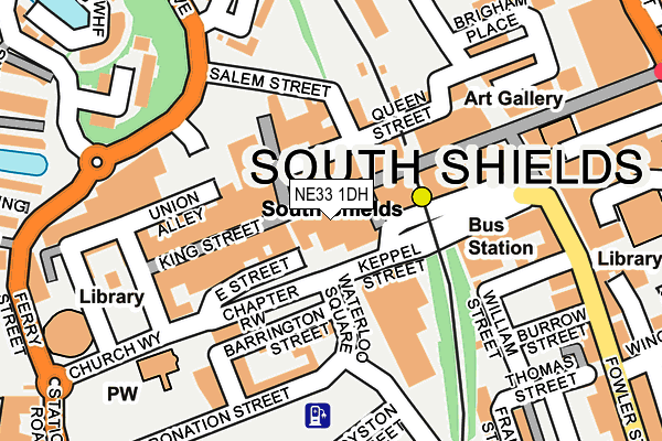
NE33 1DH lies on King Street in South Shields. NE33 1DH is located in the Beacon and Bents electoral ward, within the metropolitan district of South Tyneside and the English Parliamentary constituency of South Shields. The Sub Integrated Care Board (ICB) Location is NHS North East and North Cumbria ICB - 00N and the police force is Northumbria. This postcode has been in use since January 1980.


GetTheData
Source: OS OpenMap – Local (Ordnance Survey)
Source: OS VectorMap District (Ordnance Survey)
Licence: Open Government Licence (requires attribution)
| Easting | 436262 |
| Northing | 567194 |
| Latitude | 54.998017 |
| Longitude | -1.434715 |
GetTheData
Source: Open Postcode Geo
Licence: Open Government Licence
| Street | King Street |
| Town/City | South Shields |
| Country | England |
| Postcode District | NE33 |
➜ See where NE33 is on a map ➜ Where is South Shields? | |
GetTheData
Source: Land Registry Price Paid Data
Licence: Open Government Licence
Elevation or altitude of NE33 1DH as distance above sea level:
| Metres | Feet | |
|---|---|---|
| Elevation | 10m | 33ft |
Elevation is measured from the approximate centre of the postcode, to the nearest point on an OS contour line from OS Terrain 50, which has contour spacing of ten vertical metres.
➜ How high above sea level am I? Find the elevation of your current position using your device's GPS.
GetTheData
Source: Open Postcode Elevation
Licence: Open Government Licence
| Ward | Beacon And Bents |
| Constituency | South Shields |
GetTheData
Source: ONS Postcode Database
Licence: Open Government Licence
| Chapter Row | South Shields | 89m |
| Chapter Row | South Shields | 98m |
| Chapter Row | South Shields | 107m |
| Chapter Row | South Shields | 120m |
| East Street (Chapter Row) | South Shields | 159m |
| South Shields (Tyne And Wear Metro Station) (Smithy Street) | South Shields | 114m |
| Chichester (Tyne And Wear Metro Station) (Laygate) | Chichester | 1,303m |
| North Shields (Tyne And Wear Metro Station) (Railway Terrace) | North Shields | 1,449m |
| Brockley Whins Station | 4.6km |
GetTheData
Source: NaPTAN
Licence: Open Government Licence
GetTheData
Source: ONS Postcode Database
Licence: Open Government Licence

➜ Get more ratings from the Food Standards Agency
GetTheData
Source: Food Standards Agency
Licence: FSA terms & conditions
| Last Collection | |||
|---|---|---|---|
| Location | Mon-Fri | Sat | Distance |
| King Street | 18:30 | 40m | |
| South Shields Post Office | 18:30 | 12:00 | 148m |
| Market Place | 18:15 | 11:30 | 179m |
GetTheData
Source: Dracos
Licence: Creative Commons Attribution-ShareAlike
The below table lists the International Territorial Level (ITL) codes (formerly Nomenclature of Territorial Units for Statistics (NUTS) codes) and Local Administrative Units (LAU) codes for NE33 1DH:
| ITL 1 Code | Name |
|---|---|
| TLC | North East (England) |
| ITL 2 Code | Name |
| TLC2 | Northumberland, and Tyne and Wear |
| ITL 3 Code | Name |
| TLC22 | Tyneside |
| LAU 1 Code | Name |
| E08000023 | South Tyneside |
GetTheData
Source: ONS Postcode Directory
Licence: Open Government Licence
The below table lists the Census Output Area (OA), Lower Layer Super Output Area (LSOA), and Middle Layer Super Output Area (MSOA) for NE33 1DH:
| Code | Name | |
|---|---|---|
| OA | E00044004 | |
| LSOA | E01008667 | South Tyneside 002D |
| MSOA | E02001769 | South Tyneside 002 |
GetTheData
Source: ONS Postcode Directory
Licence: Open Government Licence
| NE33 1HZ | King Street | 35m |
| NE33 1DA | King Street | 106m |
| NE33 1BT | East Smithy Street | 109m |
| NE33 1AN | Barrington Street | 117m |
| NE33 1DP | King Street | 119m |
| NE33 1BW | East Street | 123m |
| NE33 1HT | King Street | 137m |
| NE33 1BN | Chapter Row | 151m |
| NE33 1AZ | Coronation Street | 170m |
| NE33 1NF | Fowler Street | 171m |
GetTheData
Source: Open Postcode Geo; Land Registry Price Paid Data
Licence: Open Government Licence