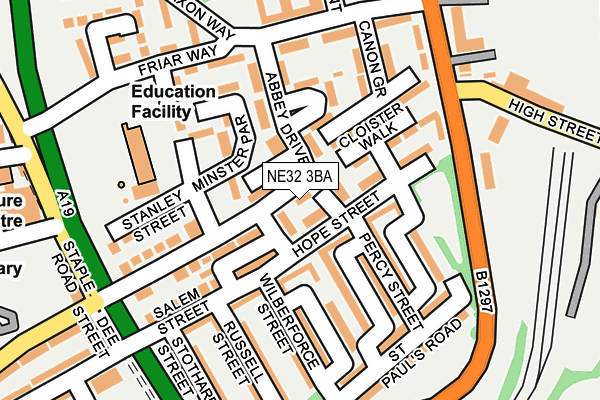
NE32 3BA is located in the Primrose electoral ward, within the metropolitan district of South Tyneside and the English Parliamentary constituency of Jarrow. The Sub Integrated Care Board (ICB) Location is NHS North East and North Cumbria ICB - 00N and the police force is Northumbria. This postcode has been in use since July 1986.


GetTheData
Source: OS OpenMap – Local (Ordnance Survey)
Source: OS VectorMap District (Ordnance Survey)
Licence: Open Government Licence (requires attribution)
| Easting | 433321 |
| Northing | 565319 |
| Latitude | 54.981373 |
| Longitude | -1.480903 |
GetTheData
Source: Open Postcode Geo
Licence: Open Government Licence
| Country | England |
| Postcode District | NE32 |
➜ See where NE32 is on a map ➜ Where is Jarrow? | |
GetTheData
Source: Land Registry Price Paid Data
Licence: Open Government Licence
Elevation or altitude of NE32 3BA as distance above sea level:
| Metres | Feet | |
|---|---|---|
| Elevation | 10m | 33ft |
Elevation is measured from the approximate centre of the postcode, to the nearest point on an OS contour line from OS Terrain 50, which has contour spacing of ten vertical metres.
➜ How high above sea level am I? Find the elevation of your current position using your device's GPS.
GetTheData
Source: Open Postcode Elevation
Licence: Open Government Licence
| Ward | Primrose |
| Constituency | Jarrow |
GetTheData
Source: ONS Postcode Database
Licence: Open Government Licence
| High Street | Jarrow | 210m |
| High Street | Jarrow | 224m |
| Howard Street-stothard Street (Howard Street) | Jarrow | 266m |
| St Bedes Rc Jmi School (Howard Street) | Jarrow | 347m |
| Priory Road-pearson Place (Pearson Place) | Jarrow | 353m |
| Jarrow (Tyne And Wear Metro Station) (Grant Street) | Jarrow | 844m |
| Bede (Tyne And Wear Metro Station) (Monksway) | Bede | 1,270m |
| Brockley Whins Station | 2.7km |
| East Boldon Station | 5.5km |
| Heworth Station | 5.8km |
GetTheData
Source: NaPTAN
Licence: Open Government Licence
| Percentage of properties with Next Generation Access | 100.0% |
| Percentage of properties with Superfast Broadband | 100.0% |
| Percentage of properties with Ultrafast Broadband | 100.0% |
| Percentage of properties with Full Fibre Broadband | 0.0% |
Superfast Broadband is between 30Mbps and 300Mbps
Ultrafast Broadband is > 300Mbps
| Percentage of properties unable to receive 2Mbps | 0.0% |
| Percentage of properties unable to receive 5Mbps | 0.0% |
| Percentage of properties unable to receive 10Mbps | 0.0% |
| Percentage of properties unable to receive 30Mbps | 0.0% |
GetTheData
Source: Ofcom
Licence: Ofcom Terms of Use (requires attribution)
GetTheData
Source: ONS Postcode Database
Licence: Open Government Licence


➜ Get more ratings from the Food Standards Agency
GetTheData
Source: Food Standards Agency
Licence: FSA terms & conditions
| Last Collection | |||
|---|---|---|---|
| Location | Mon-Fri | Sat | Distance |
| High Street | 17:00 | 10:30 | 52m |
| Jarrow Post Office | 17:15 | 10:30 | 539m |
| Monkton Terrace | 17:00 | 10:30 | 649m |
GetTheData
Source: Dracos
Licence: Creative Commons Attribution-ShareAlike
The below table lists the International Territorial Level (ITL) codes (formerly Nomenclature of Territorial Units for Statistics (NUTS) codes) and Local Administrative Units (LAU) codes for NE32 3BA:
| ITL 1 Code | Name |
|---|---|
| TLC | North East (England) |
| ITL 2 Code | Name |
| TLC2 | Northumberland, and Tyne and Wear |
| ITL 3 Code | Name |
| TLC22 | Tyneside |
| LAU 1 Code | Name |
| E08000023 | South Tyneside |
GetTheData
Source: ONS Postcode Directory
Licence: Open Government Licence
The below table lists the Census Output Area (OA), Lower Layer Super Output Area (LSOA), and Middle Layer Super Output Area (MSOA) for NE32 3BA:
| Code | Name | |
|---|---|---|
| OA | E00043672 | |
| LSOA | E01008600 | South Tyneside 007A |
| MSOA | E02001774 | South Tyneside 007 |
GetTheData
Source: ONS Postcode Directory
Licence: Open Government Licence
| NE32 3AZ | Hope Street | 42m |
| NE32 3BB | High Street | 96m |
| NE32 3AL | Cloister Walk | 110m |
| NE32 3QG | Abbey Drive | 115m |
| NE32 3AX | Percy Street | 120m |
| NE32 3AT | Derby Street | 121m |
| NE32 3AY | Raglan Street | 131m |
| NE32 3AR | Wilberforce Street | 141m |
| NE32 3BQ | High Street | 152m |
| NE32 3QR | Wellington Place | 159m |
GetTheData
Source: Open Postcode Geo; Land Registry Price Paid Data
Licence: Open Government Licence