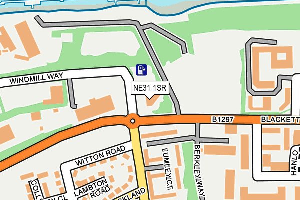
NE31 1SR is located in the Hebburn North electoral ward, within the metropolitan district of South Tyneside and the English Parliamentary constituency of Jarrow. The Sub Integrated Care Board (ICB) Location is NHS North East and North Cumbria ICB - 00N and the police force is Northumbria. This postcode has been in use since December 1996.


GetTheData
Source: OS OpenMap – Local (Ordnance Survey)
Source: OS VectorMap District (Ordnance Survey)
Licence: Open Government Licence (requires attribution)
| Easting | 431725 |
| Northing | 565650 |
| Latitude | 54.984451 |
| Longitude | -1.505802 |
GetTheData
Source: Open Postcode Geo
Licence: Open Government Licence
| Country | England |
| Postcode District | NE31 |
➜ See where NE31 is on a map ➜ Where is Hebburn? | |
GetTheData
Source: Land Registry Price Paid Data
Licence: Open Government Licence
Elevation or altitude of NE31 1SR as distance above sea level:
| Metres | Feet | |
|---|---|---|
| Elevation | 10m | 33ft |
Elevation is measured from the approximate centre of the postcode, to the nearest point on an OS contour line from OS Terrain 50, which has contour spacing of ten vertical metres.
➜ How high above sea level am I? Find the elevation of your current position using your device's GPS.
GetTheData
Source: Open Postcode Elevation
Licence: Open Government Licence
| Ward | Hebburn North |
| Constituency | Jarrow |
GetTheData
Source: ONS Postcode Database
Licence: Open Government Licence
| Blackett Street | Jarrow | 178m |
| Blackett Street | Jarrow | 198m |
| Auckland Road | Hebburn | 278m |
| Auckland Road | Hebburn | 295m |
| Viking Industrial Estate (Rolling Mill Road) | Jarrow | 376m |
| Jarrow (Tyne And Wear Metro Station) (Grant Street) | Jarrow | 952m |
| Hadrian Road (Tyne And Wear Metro Station) (Hadrian Road) | Hadrian Road | 1,082m |
| Hebburn (Tyne And Wear Metro Station) (Prince Consort Road) | Hebburn | 1,358m |
| Howdon (Tyne And Wear Metro Station) (Howdon Lane) | Howdon | 1,440m |
| Brockley Whins Station | 4km |
| Heworth Station | 4.9km |
GetTheData
Source: NaPTAN
Licence: Open Government Licence
GetTheData
Source: ONS Postcode Database
Licence: Open Government Licence


➜ Get more ratings from the Food Standards Agency
GetTheData
Source: Food Standards Agency
Licence: FSA terms & conditions
| Last Collection | |||
|---|---|---|---|
| Location | Mon-Fri | Sat | Distance |
| Auckland Road | 16:30 | 10:30 | 205m |
| Warkworth Avenue | 16:15 | 11:45 | 656m |
| Hebburn Colliery Post Office | 16:30 | 10:30 | 697m |
GetTheData
Source: Dracos
Licence: Creative Commons Attribution-ShareAlike
The below table lists the International Territorial Level (ITL) codes (formerly Nomenclature of Territorial Units for Statistics (NUTS) codes) and Local Administrative Units (LAU) codes for NE31 1SR:
| ITL 1 Code | Name |
|---|---|
| TLC | North East (England) |
| ITL 2 Code | Name |
| TLC2 | Northumberland, and Tyne and Wear |
| ITL 3 Code | Name |
| TLC22 | Tyneside |
| LAU 1 Code | Name |
| E08000023 | South Tyneside |
GetTheData
Source: ONS Postcode Directory
Licence: Open Government Licence
The below table lists the Census Output Area (OA), Lower Layer Super Output Area (LSOA), and Middle Layer Super Output Area (MSOA) for NE31 1SR:
| Code | Name | |
|---|---|---|
| OA | E00043853 | |
| LSOA | E01008639 | South Tyneside 009A |
| MSOA | E02001776 | South Tyneside 009 |
GetTheData
Source: ONS Postcode Directory
Licence: Open Government Licence
| NE31 1SF | Berkley Way | 152m |
| NE31 1SN | Witton Road | 158m |
| NE31 1SW | High Lane Row | 167m |
| NE31 1SL | Lambton Road | 202m |
| NE31 1SU | Auckland Road | 246m |
| NE31 1SJ | Brancepeth Road | 288m |
| NE31 1TE | School Street | 392m |
| NE31 1HH | Railway Street | 448m |
| NE31 1SP | Wagonway Road | 458m |
| NE31 1HJ | Page Street | 484m |
GetTheData
Source: Open Postcode Geo; Land Registry Price Paid Data
Licence: Open Government Licence