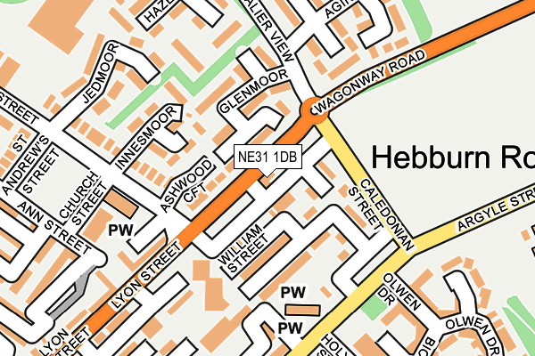
NE31 1DB is located in the Hebburn North electoral ward, within the metropolitan district of South Tyneside and the English Parliamentary constituency of Jarrow. The Sub Integrated Care Board (ICB) Location is NHS North East and North Cumbria ICB - 00N and the police force is Northumbria. This postcode has been in use since January 1980.


GetTheData
Source: OS OpenMap – Local (Ordnance Survey)
Source: OS VectorMap District (Ordnance Survey)
Licence: Open Government Licence (requires attribution)
| Easting | 430763 |
| Northing | 565150 |
| Latitude | 54.980011 |
| Longitude | -1.520875 |
GetTheData
Source: Open Postcode Geo
Licence: Open Government Licence
| Country | England |
| Postcode District | NE31 |
➜ See where NE31 is on a map ➜ Where is Hebburn? | |
GetTheData
Source: Land Registry Price Paid Data
Licence: Open Government Licence
Elevation or altitude of NE31 1DB as distance above sea level:
| Metres | Feet | |
|---|---|---|
| Elevation | 30m | 98ft |
Elevation is measured from the approximate centre of the postcode, to the nearest point on an OS contour line from OS Terrain 50, which has contour spacing of ten vertical metres.
➜ How high above sea level am I? Find the elevation of your current position using your device's GPS.
GetTheData
Source: Open Postcode Elevation
Licence: Open Government Licence
| Ward | Hebburn North |
| Constituency | Jarrow |
GetTheData
Source: ONS Postcode Database
Licence: Open Government Licence
| Lyon Street-caledonian Street (Lyon Street) | Hebburn | 30m |
| Lyon Street-cavalier View (Lyon Street) | Hebburn | 50m |
| Caledonian Street | Hebburn | 97m |
| Caledonian Street | Hebburn | 118m |
| Lyon Street-albert Street (Lyon Street) | Hebburn | 161m |
| Hebburn (Tyne And Wear Metro Station) (Prince Consort Road) | Hebburn | 488m |
| Wallsend (Tyne And Wear Metro Station) (Station Road) | Wallsend | 1,295m |
| Hadrian Road (Tyne And Wear Metro Station) (Hadrian Road) | Hadrian Road | 1,396m |
| Heworth Station | 3.9km |
| Brockley Whins Station | 4.4km |
GetTheData
Source: NaPTAN
Licence: Open Government Licence
GetTheData
Source: ONS Postcode Database
Licence: Open Government Licence


➜ Get more ratings from the Food Standards Agency
GetTheData
Source: Food Standards Agency
Licence: FSA terms & conditions
| Last Collection | |||
|---|---|---|---|
| Location | Mon-Fri | Sat | Distance |
| Albert Street | 17:00 | 10:30 | 166m |
| Albert Street | 17:30 | 10:30 | 198m |
| Argyle Street | 17:15 | 11:45 | 368m |
GetTheData
Source: Dracos
Licence: Creative Commons Attribution-ShareAlike
The below table lists the International Territorial Level (ITL) codes (formerly Nomenclature of Territorial Units for Statistics (NUTS) codes) and Local Administrative Units (LAU) codes for NE31 1DB:
| ITL 1 Code | Name |
|---|---|
| TLC | North East (England) |
| ITL 2 Code | Name |
| TLC2 | Northumberland, and Tyne and Wear |
| ITL 3 Code | Name |
| TLC22 | Tyneside |
| LAU 1 Code | Name |
| E08000023 | South Tyneside |
GetTheData
Source: ONS Postcode Directory
Licence: Open Government Licence
The below table lists the Census Output Area (OA), Lower Layer Super Output Area (LSOA), and Middle Layer Super Output Area (MSOA) for NE31 1DB:
| Code | Name | |
|---|---|---|
| OA | E00043875 | |
| LSOA | E01008640 | South Tyneside 010B |
| MSOA | E02001777 | South Tyneside 010 |
GetTheData
Source: ONS Postcode Directory
Licence: Open Government Licence
| NE31 1BT | Ashwood Croft | 67m |
| NE31 1BZ | William Street | 72m |
| NE31 1DE | Glenmoor | 80m |
| NE31 1BY | Caledonian Street | 86m |
| NE31 1DD | Cuthbert Street | 101m |
| NE31 1XH | Innesmoor | 123m |
| NE31 1EE | Ellison Street | 150m |
| NE31 1EG | Lyon Street | 153m |
| NE31 1DF | William Terrace | 168m |
| NE31 1BP | Ellison Street | 172m |
GetTheData
Source: Open Postcode Geo; Land Registry Price Paid Data
Licence: Open Government Licence