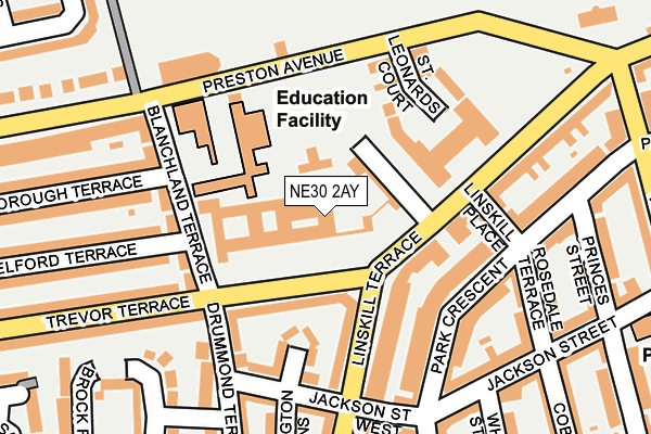
NE30 2AY is located in the Tynemouth electoral ward, within the metropolitan district of North Tyneside and the English Parliamentary constituency of Tynemouth. The Sub Integrated Care Board (ICB) Location is NHS North East and North Cumbria ICB - 99C and the police force is Northumbria. This postcode has been in use since June 1999.


GetTheData
Source: OS OpenMap – Local (Ordnance Survey)
Source: OS VectorMap District (Ordnance Survey)
Licence: Open Government Licence (requires attribution)
| Easting | 435713 |
| Northing | 569146 |
| Latitude | 55.015596 |
| Longitude | -1.443054 |
GetTheData
Source: Open Postcode Geo
Licence: Open Government Licence
| Country | England |
| Postcode District | NE30 |
➜ See where NE30 is on a map ➜ Where is Tynemouth? | |
GetTheData
Source: Land Registry Price Paid Data
Licence: Open Government Licence
Elevation or altitude of NE30 2AY as distance above sea level:
| Metres | Feet | |
|---|---|---|
| Elevation | 30m | 98ft |
Elevation is measured from the approximate centre of the postcode, to the nearest point on an OS contour line from OS Terrain 50, which has contour spacing of ten vertical metres.
➜ How high above sea level am I? Find the elevation of your current position using your device's GPS.
GetTheData
Source: Open Postcode Elevation
Licence: Open Government Licence
| Ward | Tynemouth |
| Constituency | Tynemouth |
GetTheData
Source: ONS Postcode Database
Licence: Open Government Licence
| Linskill Terrace-jackson Street (Linskill Terrace) | North Shields | 153m |
| Linskill Terrace-jackson Street (Linkill Terrace) | North Shields | 192m |
| Linskill Terrace-washington Tce (Linskill Terrace) | North Shields | 238m |
| Linskill Terrace-washington Tce (Linskill Terrace) | North Shields | 268m |
| Linskill Terrace-grey Street (Linskill Terrace) | North Shields | 336m |
| North Shields (Tyne And Wear Metro Station) (Railway Terrace) | North Shields | 888m |
| Tynemouth (Tyne And Wear Metro Station) (Station Terrace) | Tynemouth | 939m |
GetTheData
Source: NaPTAN
Licence: Open Government Licence
| Median download speed | 18.5Mbps |
| Average download speed | 16.0Mbps |
| Maximum download speed | 22.01Mbps |
| Median upload speed | 1.0Mbps |
| Average upload speed | 1.0Mbps |
| Maximum upload speed | 1.17Mbps |
GetTheData
Source: Ofcom
Licence: Ofcom Terms of Use (requires attribution)
GetTheData
Source: ONS Postcode Database
Licence: Open Government Licence


➜ Get more ratings from the Food Standards Agency
GetTheData
Source: Food Standards Agency
Licence: FSA terms & conditions
| Last Collection | |||
|---|---|---|---|
| Location | Mon-Fri | Sat | Distance |
| Linskill Terrace | 16:00 | 11:45 | 199m |
| Fontburn Terrace | 16:00 | 11:45 | 258m |
| George Stephenson Way | 16:00 | 11:15 | 310m |
GetTheData
Source: Dracos
Licence: Creative Commons Attribution-ShareAlike
The below table lists the International Territorial Level (ITL) codes (formerly Nomenclature of Territorial Units for Statistics (NUTS) codes) and Local Administrative Units (LAU) codes for NE30 2AY:
| ITL 1 Code | Name |
|---|---|
| TLC | North East (England) |
| ITL 2 Code | Name |
| TLC2 | Northumberland, and Tyne and Wear |
| ITL 3 Code | Name |
| TLC22 | Tyneside |
| LAU 1 Code | Name |
| E08000022 | North Tyneside |
GetTheData
Source: ONS Postcode Directory
Licence: Open Government Licence
The below table lists the Census Output Area (OA), Lower Layer Super Output Area (LSOA), and Middle Layer Super Output Area (MSOA) for NE30 2AY:
| Code | Name | |
|---|---|---|
| OA | E00043456 | |
| LSOA | E01008559 | North Tyneside 017C |
| MSOA | E02001754 | North Tyneside 017 |
GetTheData
Source: ONS Postcode Directory
Licence: Open Government Licence
| NE30 2AX | Trevor Terrace | 90m |
| NE30 2EW | Linskill Terrace | 100m |
| NE30 2AJ | Kensington Grove | 115m |
| NE30 2BF | Linskill Park | 116m |
| NE30 2AU | Linskill Terrace | 121m |
| NE30 2EN | Linskill Terrace | 124m |
| NE30 2AZ | Blanchland Terrace | 138m |
| NE30 2AG | Drummond Terrace | 139m |
| NE30 2BA | Blanchland Terrace | 146m |
| NE30 2HR | Park Crescent | 160m |
GetTheData
Source: Open Postcode Geo; Land Registry Price Paid Data
Licence: Open Government Licence