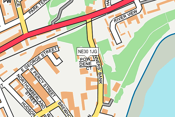
NE30 1JG is located in the Tynemouth electoral ward, within the metropolitan district of North Tyneside and the English Parliamentary constituency of Tynemouth. The Sub Integrated Care Board (ICB) Location is NHS North East and North Cumbria ICB - 99C and the police force is Northumbria. This postcode has been in use since February 2008.


GetTheData
Source: OS OpenMap – Local (Ordnance Survey)
Source: OS VectorMap District (Ordnance Survey)
Licence: Open Government Licence (requires attribution)
| Easting | 436294 |
| Northing | 568823 |
| Latitude | 55.012644 |
| Longitude | -1.433996 |
GetTheData
Source: Open Postcode Geo
Licence: Open Government Licence
| Country | England |
| Postcode District | NE30 |
➜ See where NE30 is on a map ➜ Where is Tynemouth? | |
GetTheData
Source: Land Registry Price Paid Data
Licence: Open Government Licence
Elevation or altitude of NE30 1JG as distance above sea level:
| Metres | Feet | |
|---|---|---|
| Elevation | 10m | 33ft |
Elevation is measured from the approximate centre of the postcode, to the nearest point on an OS contour line from OS Terrain 50, which has contour spacing of ten vertical metres.
➜ How high above sea level am I? Find the elevation of your current position using your device's GPS.
GetTheData
Source: Open Postcode Elevation
Licence: Open Government Licence
| Ward | Tynemouth |
| Constituency | Tynemouth |
GetTheData
Source: ONS Postcode Database
Licence: Open Government Licence
| Tynemouth Road-northumberland Park (Tynemouth Road) | North Shields | 148m |
| Tynemouth Road-northumberland Park (Tynemouth Road) | North Shields | 157m |
| Tynemouth Road-northumberland Park (Tynemouth Road) | North Shields | 195m |
| Union Road - Fish Quay (Cliffords Fort Moat) | North Shields | 212m |
| Bird Street | North Shields | 293m |
| Tynemouth (Tyne And Wear Metro Station) (Station Terrace) | Tynemouth | 607m |
| North Shields (Tyne And Wear Metro Station) (Railway Terrace) | North Shields | 1,054m |
GetTheData
Source: NaPTAN
Licence: Open Government Licence
GetTheData
Source: ONS Postcode Database
Licence: Open Government Licence


➜ Get more ratings from the Food Standards Agency
GetTheData
Source: Food Standards Agency
Licence: FSA terms & conditions
| Last Collection | |||
|---|---|---|---|
| Location | Mon-Fri | Sat | Distance |
| Washington Terrace | 16:00 | 11:45 | 383m |
| Alder Road | 400m | ||
| Mariners Lane | 16:15 | 11:45 | 408m |
GetTheData
Source: Dracos
Licence: Creative Commons Attribution-ShareAlike
The below table lists the International Territorial Level (ITL) codes (formerly Nomenclature of Territorial Units for Statistics (NUTS) codes) and Local Administrative Units (LAU) codes for NE30 1JG:
| ITL 1 Code | Name |
|---|---|
| TLC | North East (England) |
| ITL 2 Code | Name |
| TLC2 | Northumberland, and Tyne and Wear |
| ITL 3 Code | Name |
| TLC22 | Tyneside |
| LAU 1 Code | Name |
| E08000022 | North Tyneside |
GetTheData
Source: ONS Postcode Directory
Licence: Open Government Licence
The below table lists the Census Output Area (OA), Lower Layer Super Output Area (LSOA), and Middle Layer Super Output Area (MSOA) for NE30 1JG:
| Code | Name | |
|---|---|---|
| OA | E00043465 | |
| LSOA | E01008561 | North Tyneside 016C |
| MSOA | E02001753 | North Tyneside 016 |
GetTheData
Source: ONS Postcode Directory
Licence: Open Government Licence
| NE30 4AF | River View | 145m |
| NE30 4AA | Tynemouth Road | 164m |
| NE30 1DY | East George Street | 175m |
| NE30 1DS | Northumberland Street | 202m |
| NE30 2HD | Washington Terrace | 249m |
| NE30 2HA | Park Terrace | 258m |
| NE30 1HB | Union Quay | 263m |
| NE30 1DL | Hudson Street | 269m |
| NE30 1JP | Hudson Street | 284m |
| NE30 1EE | Tynemouth Road | 285m |
GetTheData
Source: Open Postcode Geo; Land Registry Price Paid Data
Licence: Open Government Licence