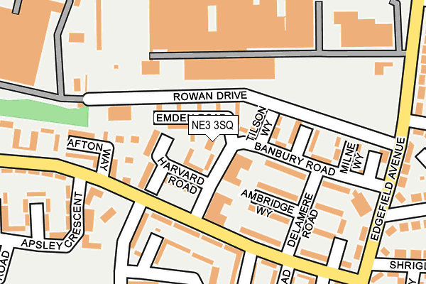
NE3 3SQ lies on Banbury Road in Newcastle Upon Tyne. NE3 3SQ is located in the Kenton electoral ward, within the metropolitan district of Newcastle upon Tyne and the English Parliamentary constituency of Newcastle upon Tyne North. The Sub Integrated Care Board (ICB) Location is NHS North East and North Cumbria ICB - 13T and the police force is Northumbria. This postcode has been in use since January 1980.


GetTheData
Source: OS OpenMap – Local (Ordnance Survey)
Source: OS VectorMap District (Ordnance Survey)
Licence: Open Government Licence (requires attribution)
| Easting | 422545 |
| Northing | 568523 |
| Latitude | 55.010758 |
| Longitude | -1.649010 |
GetTheData
Source: Open Postcode Geo
Licence: Open Government Licence
| Street | Banbury Road |
| Town/City | Newcastle Upon Tyne |
| Country | England |
| Postcode District | NE3 |
➜ See where NE3 is on a map ➜ Where is Newcastle upon Tyne? | |
GetTheData
Source: Land Registry Price Paid Data
Licence: Open Government Licence
Elevation or altitude of NE3 3SQ as distance above sea level:
| Metres | Feet | |
|---|---|---|
| Elevation | 70m | 230ft |
Elevation is measured from the approximate centre of the postcode, to the nearest point on an OS contour line from OS Terrain 50, which has contour spacing of ten vertical metres.
➜ How high above sea level am I? Find the elevation of your current position using your device's GPS.
GetTheData
Source: Open Postcode Elevation
Licence: Open Government Licence
| Ward | Kenton |
| Constituency | Newcastle Upon Tyne North |
GetTheData
Source: ONS Postcode Database
Licence: Open Government Licence
| Hillsview Avenue-newlyn Road (Hillsview Avenue) | North Kenton | 120m |
| Hillsview Avenue-newlyn Road (Hillsview Avenue) | North Kenton | 151m |
| Delamere Road | North Kenton | 183m |
| Edgefield Avenue - Overfield Road (Edgefield Avenue) | North Kenton | 251m |
| Edgefield Avenue - Overfield Road (Edgefield Avenue) | North Kenton | 260m |
| Fawdon (Tyne And Wear Metro Station) (Fawdon Lane) | Fawdon | 434m |
| Wansbeck Road (Tyne And Wear Metro Station) (Wansbeck Road North) | Coxlodge | 982m |
| Kingston Park (Tyne And Wear Metro Station) (Brunton Lane) | Kingston Park | 1,104m |
| Newcastle Airport Metro | 4.9km |
| Manors Station | 5.1km |
| Newcastle Station | 5.1km |
GetTheData
Source: NaPTAN
Licence: Open Government Licence
| Percentage of properties with Next Generation Access | 100.0% |
| Percentage of properties with Superfast Broadband | 100.0% |
| Percentage of properties with Ultrafast Broadband | 100.0% |
| Percentage of properties with Full Fibre Broadband | 0.0% |
Superfast Broadband is between 30Mbps and 300Mbps
Ultrafast Broadband is > 300Mbps
| Percentage of properties unable to receive 2Mbps | 0.0% |
| Percentage of properties unable to receive 5Mbps | 0.0% |
| Percentage of properties unable to receive 10Mbps | 0.0% |
| Percentage of properties unable to receive 30Mbps | 0.0% |
GetTheData
Source: Ofcom
Licence: Ofcom Terms of Use (requires attribution)
Estimated total energy consumption in NE3 3SQ by fuel type, 2015.
| Consumption (kWh) | 73,146 |
|---|---|
| Meter count | 7 |
| Mean (kWh/meter) | 10,449 |
| Median (kWh/meter) | 9,953 |
| Consumption (kWh) | 15,427 |
|---|---|
| Meter count | 7 |
| Mean (kWh/meter) | 2,204 |
| Median (kWh/meter) | 1,164 |
GetTheData
Source: Postcode level gas estimates: 2015 (experimental)
Source: Postcode level electricity estimates: 2015 (experimental)
Licence: Open Government Licence
GetTheData
Source: ONS Postcode Database
Licence: Open Government Licence


➜ Get more ratings from the Food Standards Agency
GetTheData
Source: Food Standards Agency
Licence: FSA terms & conditions
| Last Collection | |||
|---|---|---|---|
| Location | Mon-Fri | Sat | Distance |
| Coxlodge Post Office | 17:30 | 11:15 | 566m |
| The Cross Way | 17:30 | 11:15 | 796m |
| Creighton Avenue | 17:30 | 11:30 | 857m |
GetTheData
Source: Dracos
Licence: Creative Commons Attribution-ShareAlike
The below table lists the International Territorial Level (ITL) codes (formerly Nomenclature of Territorial Units for Statistics (NUTS) codes) and Local Administrative Units (LAU) codes for NE3 3SQ:
| ITL 1 Code | Name |
|---|---|
| TLC | North East (England) |
| ITL 2 Code | Name |
| TLC2 | Northumberland, and Tyne and Wear |
| ITL 3 Code | Name |
| TLC22 | Tyneside |
| LAU 1 Code | Name |
| E08000021 | Newcastle upon Tyne |
GetTheData
Source: ONS Postcode Directory
Licence: Open Government Licence
The below table lists the Census Output Area (OA), Lower Layer Super Output Area (LSOA), and Middle Layer Super Output Area (MSOA) for NE3 3SQ:
| Code | Name | |
|---|---|---|
| OA | E00042296 | |
| LSOA | E01008340 | Newcastle upon Tyne 003E |
| MSOA | E02001710 | Newcastle upon Tyne 003 |
GetTheData
Source: ONS Postcode Directory
Licence: Open Government Licence
| NE3 3SU | Emden Road | 48m |
| NE3 3ST | Tilson Way | 66m |
| NE3 3SX | Harvard Road | 95m |
| NE3 3SP | Banbury Road | 127m |
| NE3 3TD | Hillsview Avenue | 131m |
| NE3 3SN | Bodmin Way | 138m |
| NE3 3TA | Newlyn Road | 162m |
| NE3 3SL | Milne Way | 174m |
| NE3 3TB | Hillsview Avenue | 206m |
| NE3 3JQ | Kinross Drive | 215m |
GetTheData
Source: Open Postcode Geo; Land Registry Price Paid Data
Licence: Open Government Licence