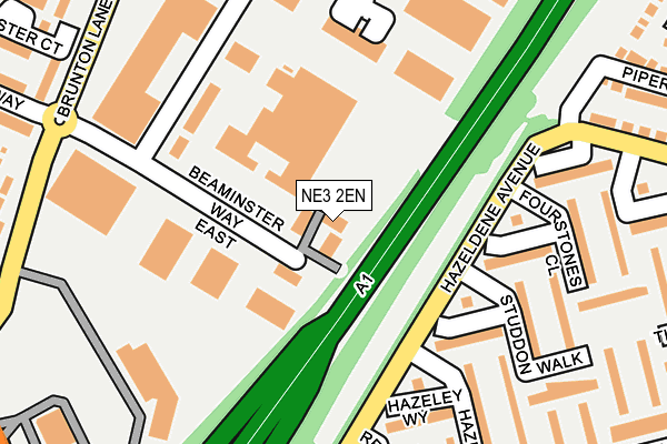
NE3 2EN is located in the Kingston Park South & Newbiggin Hall electoral ward, within the metropolitan district of Newcastle upon Tyne and the English Parliamentary constituency of Newcastle upon Tyne North. The Sub Integrated Care Board (ICB) Location is NHS North East and North Cumbria ICB - 13T and the police force is Northumbria. This postcode has been in use since September 1991.


GetTheData
Source: OS OpenMap – Local (Ordnance Survey)
Source: OS VectorMap District (Ordnance Survey)
Licence: Open Government Licence (requires attribution)
| Easting | 421523 |
| Northing | 568343 |
| Latitude | 55.009193 |
| Longitude | -1.665018 |
GetTheData
Source: Open Postcode Geo
Licence: Open Government Licence
| Country | England |
| Postcode District | NE3 |
➜ See where NE3 is on a map ➜ Where is Newcastle upon Tyne? | |
GetTheData
Source: Land Registry Price Paid Data
Licence: Open Government Licence
Elevation or altitude of NE3 2EN as distance above sea level:
| Metres | Feet | |
|---|---|---|
| Elevation | 90m | 295ft |
Elevation is measured from the approximate centre of the postcode, to the nearest point on an OS contour line from OS Terrain 50, which has contour spacing of ten vertical metres.
➜ How high above sea level am I? Find the elevation of your current position using your device's GPS.
GetTheData
Source: Open Postcode Elevation
Licence: Open Government Licence
| Ward | Kingston Park South & Newbiggin Hall |
| Constituency | Newcastle Upon Tyne North |
GetTheData
Source: ONS Postcode Database
Licence: Open Government Licence
| Kenton Bar Estate (Hazeldene Avenue) | Kenton Bar | 113m |
| Kenton Bar Estate (Hazeldene Avenue) | Kenton Bar | 120m |
| Brunton Lane-beaminster Way (Brunton Lane) | Kingston Park | 261m |
| Hazeldene Avenue-mallowburn Crescent (Hazeldene Avenue) | Kenton Bar | 276m |
| Brunton Lane-tudor Way (Brunton Lane) | Kingston Park | 280m |
| Kingston Park (Tyne And Wear Metro Station) (Brunton Lane) | Kingston Park | 577m |
| Bank Foot (Tyne And Wear Metro Station) (Station Road) | Kenton Bank Foot | 995m |
| Fawdon (Tyne And Wear Metro Station) (Fawdon Lane) | Fawdon | 1,399m |
| Newcastle Airport Metro | 4.2km |
| Newcastle Station | 5.5km |
| Manors Station | 5.6km |
GetTheData
Source: NaPTAN
Licence: Open Government Licence
| Median download speed | 79.6Mbps |
| Average download speed | 52.7Mbps |
| Maximum download speed | 80.00Mbps |
| Median upload speed | 20.0Mbps |
| Average upload speed | 12.3Mbps |
| Maximum upload speed | 20.00Mbps |
GetTheData
Source: Ofcom
Licence: Ofcom Terms of Use (requires attribution)
Estimated total energy consumption in NE3 2EN by fuel type, 2015.
| Consumption (kWh) | 139,409 |
|---|---|
| Meter count | 7 |
| Mean (kWh/meter) | 19,916 |
| Median (kWh/meter) | 18,217 |
GetTheData
Source: Postcode level gas estimates: 2015 (experimental)
Source: Postcode level electricity estimates: 2015 (experimental)
Licence: Open Government Licence
GetTheData
Source: ONS Postcode Database
Licence: Open Government Licence


➜ Get more ratings from the Food Standards Agency
GetTheData
Source: Food Standards Agency
Licence: FSA terms & conditions
| Last Collection | |||
|---|---|---|---|
| Location | Mon-Fri | Sat | Distance |
| Mallowburn Crescent | 17:30 | 11:30 | 362m |
| Tesco Kingston Park | 18:30 | 11:15 | 558m |
| Tudor Way | 17:30 | 11:15 | 665m |
GetTheData
Source: Dracos
Licence: Creative Commons Attribution-ShareAlike
The below table lists the International Territorial Level (ITL) codes (formerly Nomenclature of Territorial Units for Statistics (NUTS) codes) and Local Administrative Units (LAU) codes for NE3 2EN:
| ITL 1 Code | Name |
|---|---|
| TLC | North East (England) |
| ITL 2 Code | Name |
| TLC2 | Northumberland, and Tyne and Wear |
| ITL 3 Code | Name |
| TLC22 | Tyneside |
| LAU 1 Code | Name |
| E08000021 | Newcastle upon Tyne |
GetTheData
Source: ONS Postcode Directory
Licence: Open Government Licence
The below table lists the Census Output Area (OA), Lower Layer Super Output Area (LSOA), and Middle Layer Super Output Area (MSOA) for NE3 2EN:
| Code | Name | |
|---|---|---|
| OA | E00042072 | |
| LSOA | E01008295 | Newcastle upon Tyne 008A |
| MSOA | E02001715 | Newcastle upon Tyne 008 |
GetTheData
Source: ONS Postcode Directory
Licence: Open Government Licence
| NE3 3XZ | Hazeldene Avenue | 137m |
| NE3 3YS | Laverock Place | 159m |
| NE3 3YY | Dunnykirk Avenue | 166m |
| NE3 3YW | Hazeley Way | 195m |
| NE3 3ES | Gunnerston Grove | 222m |
| NE3 3YZ | Fourstones Close | 234m |
| NE3 3YP | Hazeley Grove | 242m |
| NE3 3YN | Reestones Place | 249m |
| NE3 3YQ | Studdon Walk | 251m |
| NE3 3YR | Studdon Walk | 262m |
GetTheData
Source: Open Postcode Geo; Land Registry Price Paid Data
Licence: Open Government Licence