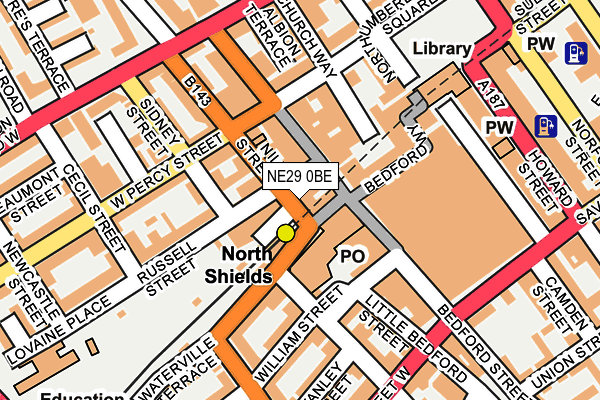
NE29 0BE is located in the Riverside electoral ward, within the metropolitan district of North Tyneside and the English Parliamentary constituency of North Tyneside. The Sub Integrated Care Board (ICB) Location is NHS North East and North Cumbria ICB - 99C and the police force is Northumbria. This postcode has been in use since January 1980.


GetTheData
Source: OS OpenMap – Local (Ordnance Survey)
Source: OS VectorMap District (Ordnance Survey)
Licence: Open Government Licence (requires attribution)
| Easting | 435398 |
| Northing | 568395 |
| Latitude | 55.008871 |
| Longitude | -1.448072 |
GetTheData
Source: Open Postcode Geo
Licence: Open Government Licence
| Country | England |
| Postcode District | NE29 |
➜ See where NE29 is on a map ➜ Where is Tynemouth? | |
GetTheData
Source: Land Registry Price Paid Data
Licence: Open Government Licence
Elevation or altitude of NE29 0BE as distance above sea level:
| Metres | Feet | |
|---|---|---|
| Elevation | 30m | 98ft |
Elevation is measured from the approximate centre of the postcode, to the nearest point on an OS contour line from OS Terrain 50, which has contour spacing of ten vertical metres.
➜ How high above sea level am I? Find the elevation of your current position using your device's GPS.
GetTheData
Source: Open Postcode Elevation
Licence: Open Government Licence
| Ward | Riverside |
| Constituency | North Tyneside |
GetTheData
Source: ONS Postcode Database
Licence: Open Government Licence
| Nile Street (Railway Terrace) | North Shields | 7m |
| Railway Terrace-metro Station (Railway Terrace) | North Shields | 44m |
| Railway Terrace | North Shields | 59m |
| West Percy Street | North Shields | 84m |
| Rudyerd Street | North Shields | 86m |
| North Shields (Tyne And Wear Metro Station) (Railway Terrace) | North Shields | 74m |
| Meadow Well (Tyne And Wear Metro Station) (Ripley Avenue) | Meadow Well | 1,363m |
| South Shields (Tyne And Wear Metro Station) (Smithy Street) | South Shields | 1,517m |
| Tynemouth (Tyne And Wear Metro Station) (Station Terrace) | Tynemouth | 1,548m |
GetTheData
Source: NaPTAN
Licence: Open Government Licence
GetTheData
Source: ONS Postcode Database
Licence: Open Government Licence


➜ Get more ratings from the Food Standards Agency
GetTheData
Source: Food Standards Agency
Licence: FSA terms & conditions
| Last Collection | |||
|---|---|---|---|
| Location | Mon-Fri | Sat | Distance |
| Nile Street Post Office | 18:30 | 12:30 | 26m |
| Co-op Post Office | 18:30 | 12:30 | 54m |
| Northumberland Square | 18:30 | 12:15 | 192m |
GetTheData
Source: Dracos
Licence: Creative Commons Attribution-ShareAlike
The below table lists the International Territorial Level (ITL) codes (formerly Nomenclature of Territorial Units for Statistics (NUTS) codes) and Local Administrative Units (LAU) codes for NE29 0BE:
| ITL 1 Code | Name |
|---|---|
| TLC | North East (England) |
| ITL 2 Code | Name |
| TLC2 | Northumberland, and Tyne and Wear |
| ITL 3 Code | Name |
| TLC22 | Tyneside |
| LAU 1 Code | Name |
| E08000022 | North Tyneside |
GetTheData
Source: ONS Postcode Directory
Licence: Open Government Licence
The below table lists the Census Output Area (OA), Lower Layer Super Output Area (LSOA), and Middle Layer Super Output Area (MSOA) for NE29 0BE:
| Code | Name | |
|---|---|---|
| OA | E00043273 | |
| LSOA | E01008524 | North Tyneside 022B |
| MSOA | E02001759 | North Tyneside 022 |
GetTheData
Source: ONS Postcode Directory
Licence: Open Government Licence
| NE29 6QF | Bedford Street | 29m |
| NE29 0BL | Russell Street | 53m |
| NE29 0BD | Nile Street | 53m |
| NE29 0BG | Nile Street | 55m |
| NE29 0AT | Bedford Street | 72m |
| NE29 0AY | West Percy Street | 77m |
| NE29 0DR | West Percy Street | 91m |
| NE29 0AH | West Percy Street | 94m |
| NE29 0AG | West Percy Street | 119m |
| NE29 0AR | Bedford Street | 125m |
GetTheData
Source: Open Postcode Geo; Land Registry Price Paid Data
Licence: Open Government Licence