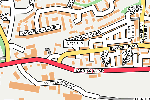
NE28 6LP lies on Carlyle Street in Wallsend. NE28 6LP is located in the Riverside electoral ward, within the metropolitan district of North Tyneside and the English Parliamentary constituency of North Tyneside. The Sub Integrated Care Board (ICB) Location is NHS North East and North Cumbria ICB - 99C and the police force is Northumbria. This postcode has been in use since January 1980.


GetTheData
Source: OS OpenMap – Local (Ordnance Survey)
Source: OS VectorMap District (Ordnance Survey)
Licence: Open Government Licence (requires attribution)
| Easting | 432305 |
| Northing | 566452 |
| Latitude | 54.991621 |
| Longitude | -1.496650 |
GetTheData
Source: Open Postcode Geo
Licence: Open Government Licence
| Street | Carlyle Street |
| Town/City | Wallsend |
| Country | England |
| Postcode District | NE28 |
➜ See where NE28 is on a map ➜ Where is Wallsend? | |
GetTheData
Source: Land Registry Price Paid Data
Licence: Open Government Licence
Elevation or altitude of NE28 6LP as distance above sea level:
| Metres | Feet | |
|---|---|---|
| Elevation | 20m | 66ft |
Elevation is measured from the approximate centre of the postcode, to the nearest point on an OS contour line from OS Terrain 50, which has contour spacing of ten vertical metres.
➜ How high above sea level am I? Find the elevation of your current position using your device's GPS.
GetTheData
Source: Open Postcode Elevation
Licence: Open Government Licence
| Ward | Riverside |
| Constituency | North Tyneside |
GetTheData
Source: ONS Postcode Database
Licence: Open Government Licence
| Bewicke Road | Willington Quay | 48m |
| Bewicke Road | Willington Quay | 49m |
| Bewicke Road-addison Court (Bewicke Road) | Willington Quay | 178m |
| Clavering Street | Willington Quay | 243m |
| Western Road-hadrian Road (Western Road) | Willington Quay | 286m |
| Howdon (Tyne And Wear Metro Station) (Howdon Lane) | Howdon | 468m |
| Hadrian Road (Tyne And Wear Metro Station) (Hadrian Road) | Hadrian Road | 1,235m |
| Jarrow (Tyne And Wear Metro Station) (Grant Street) | Jarrow | 1,362m |
| Percy Main (Tyne And Wear Metro Station) (Burdon Street) | Percy Main | 1,683m |
| Brockley Whins Station | 4.2km |
| Heworth Station | 5.8km |
| East Boldon Station | 7km |
GetTheData
Source: NaPTAN
Licence: Open Government Licence
| Percentage of properties with Next Generation Access | 100.0% |
| Percentage of properties with Superfast Broadband | 100.0% |
| Percentage of properties with Ultrafast Broadband | 100.0% |
| Percentage of properties with Full Fibre Broadband | 0.0% |
Superfast Broadband is between 30Mbps and 300Mbps
Ultrafast Broadband is > 300Mbps
| Percentage of properties unable to receive 2Mbps | 0.0% |
| Percentage of properties unable to receive 5Mbps | 0.0% |
| Percentage of properties unable to receive 10Mbps | 0.0% |
| Percentage of properties unable to receive 30Mbps | 0.0% |
GetTheData
Source: Ofcom
Licence: Ofcom Terms of Use (requires attribution)
GetTheData
Source: ONS Postcode Database
Licence: Open Government Licence


➜ Get more ratings from the Food Standards Agency
GetTheData
Source: Food Standards Agency
Licence: FSA terms & conditions
| Last Collection | |||
|---|---|---|---|
| Location | Mon-Fri | Sat | Distance |
| Warkworth Avenue | 16:15 | 11:45 | 353m |
| Point Pleasant Industrial Est | 555m | ||
| High Howdon Post Office | 17:45 | 11:00 | 672m |
GetTheData
Source: Dracos
Licence: Creative Commons Attribution-ShareAlike
The below table lists the International Territorial Level (ITL) codes (formerly Nomenclature of Territorial Units for Statistics (NUTS) codes) and Local Administrative Units (LAU) codes for NE28 6LP:
| ITL 1 Code | Name |
|---|---|
| TLC | North East (England) |
| ITL 2 Code | Name |
| TLC2 | Northumberland, and Tyne and Wear |
| ITL 3 Code | Name |
| TLC22 | Tyneside |
| LAU 1 Code | Name |
| E08000022 | North Tyneside |
GetTheData
Source: ONS Postcode Directory
Licence: Open Government Licence
The below table lists the Census Output Area (OA), Lower Layer Super Output Area (LSOA), and Middle Layer Super Output Area (MSOA) for NE28 6LP:
| Code | Name | |
|---|---|---|
| OA | E00166120 | |
| LSOA | E01008543 | North Tyneside 028C |
| MSOA | E02001765 | North Tyneside 028 |
GetTheData
Source: ONS Postcode Directory
Licence: Open Government Licence
| NE28 6NA | Armstrong Road | 21m |
| NE28 6NE | Denewood Court | 36m |
| NE28 6LR | Smeaton Street | 42m |
| NE28 6NJ | Bewicke Road | 43m |
| NE28 6LY | Bewicke Road | 64m |
| NE28 6EA | Hanover Gardens | 77m |
| NE28 6RS | Carlyle Court | 80m |
| NE28 6RR | Smeaton Court | 103m |
| NE28 6NB | Station Road | 112m |
| NE28 0BH | Haydon Drive | 126m |
GetTheData
Source: Open Postcode Geo; Land Registry Price Paid Data
Licence: Open Government Licence