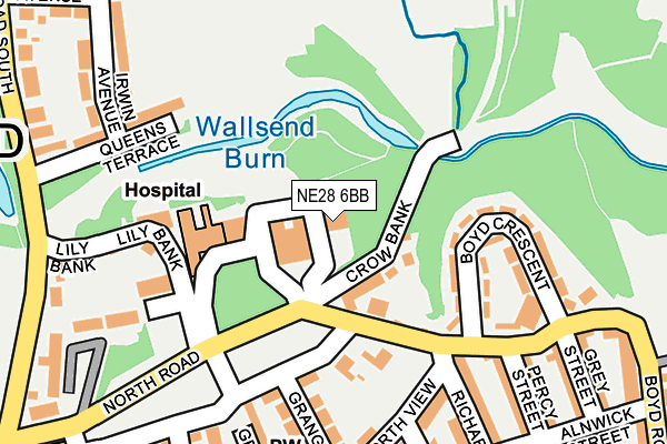
NE28 6BB is located in the Wallsend electoral ward, within the metropolitan district of North Tyneside and the English Parliamentary constituency of North Tyneside. The Sub Integrated Care Board (ICB) Location is NHS North East and North Cumbria ICB - 99C and the police force is Northumbria. This postcode has been in use since January 1993.


GetTheData
Source: OS OpenMap – Local (Ordnance Survey)
Source: OS VectorMap District (Ordnance Survey)
Licence: Open Government Licence (requires attribution)
| Easting | 430213 |
| Northing | 566960 |
| Latitude | 54.996309 |
| Longitude | -1.529278 |
GetTheData
Source: Open Postcode Geo
Licence: Open Government Licence
| Country | England |
| Postcode District | NE28 |
➜ See where NE28 is on a map ➜ Where is Wallsend? | |
GetTheData
Source: Land Registry Price Paid Data
Licence: Open Government Licence
Elevation or altitude of NE28 6BB as distance above sea level:
| Metres | Feet | |
|---|---|---|
| Elevation | 20m | 66ft |
Elevation is measured from the approximate centre of the postcode, to the nearest point on an OS contour line from OS Terrain 50, which has contour spacing of ten vertical metres.
➜ How high above sea level am I? Find the elevation of your current position using your device's GPS.
GetTheData
Source: Open Postcode Elevation
Licence: Open Government Licence
| Ward | Wallsend |
| Constituency | North Tyneside |
GetTheData
Source: ONS Postcode Database
Licence: Open Government Licence
| Burnside High School (Boyd Road) | Wallsend | 458m |
| Richardson Dees School (Westmoreland Street) | Wallsend | 491m |
| Town Hall (High Street East) | Wallsend | 496m |
| High Street East-court Building (High Street East) | Wallsend | 498m |
| High Street East - Park Road (High Street East) | Wallsend | 519m |
| Wallsend (Tyne And Wear Metro Station) (Station Road) | Wallsend | 771m |
| Hadrian Road (Tyne And Wear Metro Station) (Hadrian Road) | Hadrian Road | 968m |
| Heworth Station | 5.3km |
| Manors Station | 5.5km |
| Brockley Whins Station | 6km |
GetTheData
Source: NaPTAN
Licence: Open Government Licence
GetTheData
Source: ONS Postcode Database
Licence: Open Government Licence


➜ Get more ratings from the Food Standards Agency
GetTheData
Source: Food Standards Agency
Licence: FSA terms & conditions
| Last Collection | |||
|---|---|---|---|
| Location | Mon-Fri | Sat | Distance |
| High View | 16:15 | 11:15 | 474m |
| Park Road | 16:15 | 11:00 | 626m |
| Church Bank | 18:30 | 11:00 | 729m |
GetTheData
Source: Dracos
Licence: Creative Commons Attribution-ShareAlike
The below table lists the International Territorial Level (ITL) codes (formerly Nomenclature of Territorial Units for Statistics (NUTS) codes) and Local Administrative Units (LAU) codes for NE28 6BB:
| ITL 1 Code | Name |
|---|---|
| TLC | North East (England) |
| ITL 2 Code | Name |
| TLC2 | Northumberland, and Tyne and Wear |
| ITL 3 Code | Name |
| TLC22 | Tyneside |
| LAU 1 Code | Name |
| E08000022 | North Tyneside |
GetTheData
Source: ONS Postcode Directory
Licence: Open Government Licence
The below table lists the Census Output Area (OA), Lower Layer Super Output Area (LSOA), and Middle Layer Super Output Area (MSOA) for NE28 6BB:
| Code | Name | |
|---|---|---|
| OA | E00043515 | |
| LSOA | E01008574 | North Tyneside 029C |
| MSOA | E02001766 | North Tyneside 029 |
GetTheData
Source: ONS Postcode Directory
Licence: Open Government Licence
| NE28 7PF | Crow Bank | 60m |
| NE28 7PG | The Green | 84m |
| NE28 7NJ | Back Elm Terrace | 158m |
| NE28 7SG | Boyd Crescent | 164m |
| NE28 7NX | Lily Bank | 166m |
| NE28 7NU | Elm Terrace | 172m |
| NE28 7PL | Grange Villas | 199m |
| NE28 7SL | Boyd Road | 200m |
| NE28 7QU | Queens Terrace | 208m |
| NE28 7PP | North View | 208m |
GetTheData
Source: Open Postcode Geo; Land Registry Price Paid Data
Licence: Open Government Licence