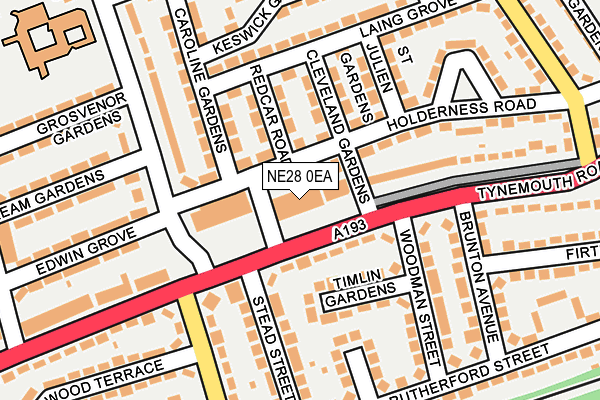
NE28 0EA lies on Tynemouth Road in Wallsend. NE28 0EA is located in the Howdon electoral ward, within the metropolitan district of North Tyneside and the English Parliamentary constituency of North Tyneside. The Sub Integrated Care Board (ICB) Location is NHS North East and North Cumbria ICB - 99C and the police force is Northumbria. This postcode has been in use since January 1980.


GetTheData
Source: OS OpenMap – Local (Ordnance Survey)
Source: OS VectorMap District (Ordnance Survey)
Licence: Open Government Licence (requires attribution)
| Easting | 432517 |
| Northing | 567227 |
| Latitude | 54.998563 |
| Longitude | -1.493236 |
GetTheData
Source: Open Postcode Geo
Licence: Open Government Licence
| Street | Tynemouth Road |
| Town/City | Wallsend |
| Country | England |
| Postcode District | NE28 |
➜ See where NE28 is on a map ➜ Where is Wallsend? | |
GetTheData
Source: Land Registry Price Paid Data
Licence: Open Government Licence
Elevation or altitude of NE28 0EA as distance above sea level:
| Metres | Feet | |
|---|---|---|
| Elevation | 40m | 131ft |
Elevation is measured from the approximate centre of the postcode, to the nearest point on an OS contour line from OS Terrain 50, which has contour spacing of ten vertical metres.
➜ How high above sea level am I? Find the elevation of your current position using your device's GPS.
GetTheData
Source: Open Postcode Elevation
Licence: Open Government Licence
| Ward | Howdon |
| Constituency | North Tyneside |
GetTheData
Source: ONS Postcode Database
Licence: Open Government Licence
| Tynemouth Road - Denbigh Avenue (Tynemouth Road) | Howdon | 87m |
| Howdon Lane | Howdon | 163m |
| Tynemouth Road - Howdon Lane (Tynemouth Road) | Howdon | 186m |
| Tynemouth Road-brunton Avenue (Tynemouth Road) | Howdon | 193m |
| Ridley Avenue-holderness Road (Ridley Avenue) | Howdon | 276m |
| Howdon (Tyne And Wear Metro Station) (Howdon Lane) | Howdon | 336m |
| Percy Main (Tyne And Wear Metro Station) (Burdon Street) | Percy Main | 1,226m |
| Hadrian Road (Tyne And Wear Metro Station) (Hadrian Road) | Hadrian Road | 1,613m |
| Brockley Whins Station | 4.8km |
GetTheData
Source: NaPTAN
Licence: Open Government Licence
GetTheData
Source: ONS Postcode Database
Licence: Open Government Licence


➜ Get more ratings from the Food Standards Agency
GetTheData
Source: Food Standards Agency
Licence: FSA terms & conditions
| Last Collection | |||
|---|---|---|---|
| Location | Mon-Fri | Sat | Distance |
| High Howdon Post Office | 17:45 | 11:00 | 645m |
| Point Pleasant Industrial Est | 1,090m | ||
| Warkworth Avenue | 16:15 | 11:45 | 1,155m |
GetTheData
Source: Dracos
Licence: Creative Commons Attribution-ShareAlike
The below table lists the International Territorial Level (ITL) codes (formerly Nomenclature of Territorial Units for Statistics (NUTS) codes) and Local Administrative Units (LAU) codes for NE28 0EA:
| ITL 1 Code | Name |
|---|---|
| TLC | North East (England) |
| ITL 2 Code | Name |
| TLC2 | Northumberland, and Tyne and Wear |
| ITL 3 Code | Name |
| TLC22 | Tyneside |
| LAU 1 Code | Name |
| E08000022 | North Tyneside |
GetTheData
Source: ONS Postcode Directory
Licence: Open Government Licence
The below table lists the Census Output Area (OA), Lower Layer Super Output Area (LSOA), and Middle Layer Super Output Area (MSOA) for NE28 0EA:
| Code | Name | |
|---|---|---|
| OA | E00043202 | |
| LSOA | E01008510 | North Tyneside 026C |
| MSOA | E02001763 | North Tyneside 026 |
GetTheData
Source: ONS Postcode Directory
Licence: Open Government Licence
| NE28 0BA | Tynemouth Road | 61m |
| NE28 0DB | Holderness Road | 69m |
| NE28 0DQ | Cleveland Gardens | 83m |
| NE28 0AT | Timlin Gardens | 95m |
| NE28 0DD | Redcar Road | 97m |
| NE28 0DH | St Julien Gardens | 140m |
| NE28 0BU | Denbigh Avenue | 145m |
| NE28 0AP | Stead Street | 149m |
| NE28 0BZ | Caroline Gardens | 151m |
| NE28 0DE | Laing Grove | 152m |
GetTheData
Source: Open Postcode Geo; Land Registry Price Paid Data
Licence: Open Government Licence