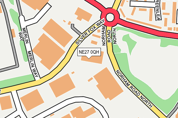
NE27 0QH lies on Silver Fox Way in New York Industrial Park, Newcastle Upon Tyne. NE27 0QH is located in the Collingwood electoral ward, within the metropolitan district of North Tyneside and the English Parliamentary constituency of Tynemouth. The Sub Integrated Care Board (ICB) Location is NHS North East and North Cumbria ICB - 99C and the police force is Northumbria. This postcode has been in use since June 2000.


GetTheData
Source: OS OpenMap – Local (Ordnance Survey)
Source: OS VectorMap District (Ordnance Survey)
Licence: Open Government Licence (requires attribution)
| Easting | 432420 |
| Northing | 569966 |
| Latitude | 55.023190 |
| Longitude | -1.494456 |
GetTheData
Source: Open Postcode Geo
Licence: Open Government Licence
| Street | Silver Fox Way |
| Locality | New York Industrial Park |
| Town/City | Newcastle Upon Tyne |
| Country | England |
| Postcode District | NE27 |
➜ See where NE27 is on a map ➜ Where is Tynemouth? | |
GetTheData
Source: Land Registry Price Paid Data
Licence: Open Government Licence
Elevation or altitude of NE27 0QH as distance above sea level:
| Metres | Feet | |
|---|---|---|
| Elevation | 70m | 230ft |
Elevation is measured from the approximate centre of the postcode, to the nearest point on an OS contour line from OS Terrain 50, which has contour spacing of ten vertical metres.
➜ How high above sea level am I? Find the elevation of your current position using your device's GPS.
GetTheData
Source: Open Postcode Elevation
Licence: Open Government Licence
| Ward | Collingwood |
| Constituency | Tynemouth |
GetTheData
Source: ONS Postcode Database
Licence: Open Government Licence
| Silver Fox Way-garage (Silver Fox Way) | New York | 64m |
| Silver Fox Way-garage (Silver Fox Way) | New York | 73m |
| New York Road-the Wheatsheaf (New York Road) | New York | 243m |
| New York Road-greenlea (New York Road) | New York | 264m |
| Norham Road North-shiremoor Farm (Northam Road) | New York | 283m |
GetTheData
Source: NaPTAN
Licence: Open Government Licence
GetTheData
Source: ONS Postcode Database
Licence: Open Government Licence


➜ Get more ratings from the Food Standards Agency
GetTheData
Source: Food Standards Agency
Licence: FSA terms & conditions
| Last Collection | |||
|---|---|---|---|
| Location | Mon-Fri | Sat | Distance |
| North Tyneside Delivery Office | 18:45 | 12:45 | 557m |
| Silverlink Industrial Estate | 18:45 | 10:30 | 653m |
| Malvern Rod | 16:30 | 12:45 | 799m |
GetTheData
Source: Dracos
Licence: Creative Commons Attribution-ShareAlike
The below table lists the International Territorial Level (ITL) codes (formerly Nomenclature of Territorial Units for Statistics (NUTS) codes) and Local Administrative Units (LAU) codes for NE27 0QH:
| ITL 1 Code | Name |
|---|---|
| TLC | North East (England) |
| ITL 2 Code | Name |
| TLC2 | Northumberland, and Tyne and Wear |
| ITL 3 Code | Name |
| TLC22 | Tyneside |
| LAU 1 Code | Name |
| E08000022 | North Tyneside |
GetTheData
Source: ONS Postcode Directory
Licence: Open Government Licence
The below table lists the Census Output Area (OA), Lower Layer Super Output Area (LSOA), and Middle Layer Super Output Area (MSOA) for NE27 0QH:
| Code | Name | |
|---|---|---|
| OA | E00043074 | |
| LSOA | E01008488 | North Tyneside 015A |
| MSOA | E02001752 | North Tyneside 015 |
GetTheData
Source: ONS Postcode Directory
Licence: Open Government Licence
| NE29 8HH | Greenlea | 231m |
| NE29 8HJ | Greenlea | 268m |
| NE29 8HQ | Greenlea | 294m |
| NE27 0QF | New York Way | 308m |
| NE29 8EL | New York Road | 313m |
| NE29 8EN | Locksley Close | 371m |
| NE29 8ES | Warenton Place | 393m |
| NE29 8EJ | Dereham Way | 399m |
| NE29 8BT | Guisborough Drive | 405m |
| NE29 8ED | Forsyth Street | 419m |
GetTheData
Source: Open Postcode Geo; Land Registry Price Paid Data
Licence: Open Government Licence