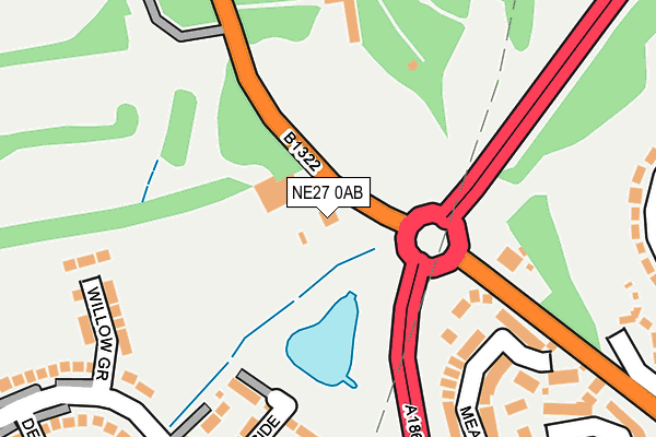
NE27 0AB lies on Station Road in Backworth, Newcastle Upon Tyne. NE27 0AB is located in the Valley electoral ward, within the metropolitan district of North Tyneside and the English Parliamentary constituency of Tynemouth. The Sub Integrated Care Board (ICB) Location is NHS North East and North Cumbria ICB - 99C and the police force is Northumbria. This postcode has been in use since January 1980.


GetTheData
Source: OS OpenMap – Local (Ordnance Survey)
Source: OS VectorMap District (Ordnance Survey)
Licence: Open Government Licence (requires attribution)
| Easting | 430437 |
| Northing | 571528 |
| Latitude | 55.037342 |
| Longitude | -1.525292 |
GetTheData
Source: Open Postcode Geo
Licence: Open Government Licence
| Street | Station Road |
| Locality | Backworth |
| Town/City | Newcastle Upon Tyne |
| Country | England |
| Postcode District | NE27 |
➜ See where NE27 is on a map ➜ Where is Backworth? | |
GetTheData
Source: Land Registry Price Paid Data
Licence: Open Government Licence
Elevation or altitude of NE27 0AB as distance above sea level:
| Metres | Feet | |
|---|---|---|
| Elevation | 60m | 197ft |
Elevation is measured from the approximate centre of the postcode, to the nearest point on an OS contour line from OS Terrain 50, which has contour spacing of ten vertical metres.
➜ How high above sea level am I? Find the elevation of your current position using your device's GPS.
GetTheData
Source: Open Postcode Elevation
Licence: Open Government Licence
| Ward | Valley |
| Constituency | Tynemouth |
GetTheData
Source: ONS Postcode Database
Licence: Open Government Licence
PARKSIDE, STATION ROAD, BACKWORTH, NEWCASTLE UPON TYNE, NE27 0AB 2021 21 SEP £550,000 |
PARKSIDE, STATION ROAD, BACKWORTH, NEWCASTLE UPON TYNE, NE27 0AB 1996 23 OCT £155,000 |
GetTheData
Source: HM Land Registry Price Paid Data
Licence: Contains HM Land Registry data © Crown copyright and database right 2025. This data is licensed under the Open Government Licence v3.0.
| Station Road-business Park (Station Road) | Backworth | 305m |
| Station Road-business Park (Station Road) | Backworth | 349m |
| Station Road-havelock Road (Station Road) | Backworth | 374m |
| Station Road-havelock Road (Station Road) | Backworth | 404m |
| Shrewsbury Drive | Backworth | 520m |
| Northumberland Park (Tyne & Wear Metro Station) (Station Road) | Northumberland Park | 584m |
| Shiremoor (Tyne And Wear Metro Station) (Park Lane) | Shiremoor | 1,299m |
| Palmersville (Tyne And Wear Metro Station) (Great Lime Road) | Palmersville | 1,794m |
GetTheData
Source: NaPTAN
Licence: Open Government Licence
GetTheData
Source: ONS Postcode Database
Licence: Open Government Licence


➜ Get more ratings from the Food Standards Agency
GetTheData
Source: Food Standards Agency
Licence: FSA terms & conditions
| Last Collection | |||
|---|---|---|---|
| Location | Mon-Fri | Sat | Distance |
| Cartington Avenue | 16:15 | 11:00 | 405m |
| West Allotment Post Office | 16:30 | 11:30 | 411m |
| Backworth Lane | 16:00 | 11:15 | 788m |
GetTheData
Source: Dracos
Licence: Creative Commons Attribution-ShareAlike
The below table lists the International Territorial Level (ITL) codes (formerly Nomenclature of Territorial Units for Statistics (NUTS) codes) and Local Administrative Units (LAU) codes for NE27 0AB:
| ITL 1 Code | Name |
|---|---|
| TLC | North East (England) |
| ITL 2 Code | Name |
| TLC2 | Northumberland, and Tyne and Wear |
| ITL 3 Code | Name |
| TLC22 | Tyneside |
| LAU 1 Code | Name |
| E08000022 | North Tyneside |
GetTheData
Source: ONS Postcode Directory
Licence: Open Government Licence
The below table lists the Census Output Area (OA), Lower Layer Super Output Area (LSOA), and Middle Layer Super Output Area (MSOA) for NE27 0AB:
| Code | Name | |
|---|---|---|
| OA | E00166127 | |
| LSOA | E01032647 | North Tyneside 011E |
| MSOA | E02001748 | North Tyneside 011 |
GetTheData
Source: ONS Postcode Directory
Licence: Open Government Licence
| NE27 0AA | Station Road | 172m |
| NE27 0BF | Meadow Vale | 289m |
| NE27 0BD | Meadow Vale | 313m |
| NE27 0RZ | Harle Road | 322m |
| NE27 0SE | Haydon Gardens | 344m |
| NE27 0SB | Hartside Crescent | 390m |
| NE27 0SA | Havelock Road | 394m |
| NE27 0RU | Station Road | 443m |
| NE27 0SD | Hartside Crescent | 459m |
| NE27 0SG | Halton Drive | 473m |
GetTheData
Source: Open Postcode Geo; Land Registry Price Paid Data
Licence: Open Government Licence