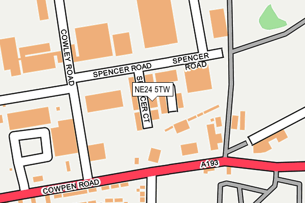
NE24 5TW is located in the Cowpen electoral ward, within the unitary authority of Northumberland and the English Parliamentary constituency of Blyth Valley. The Sub Integrated Care Board (ICB) Location is NHS North East and North Cumbria ICB - 00L and the police force is Northumbria. This postcode has been in use since December 1995.


GetTheData
Source: OS OpenMap – Local (Ordnance Survey)
Source: OS VectorMap District (Ordnance Survey)
Licence: Open Government Licence (requires attribution)
| Easting | 429965 |
| Northing | 582098 |
| Latitude | 55.132356 |
| Longitude | -1.531583 |
GetTheData
Source: Open Postcode Geo
Licence: Open Government Licence
| Country | England |
| Postcode District | NE24 |
➜ See where NE24 is on a map ➜ Where is Blyth? | |
GetTheData
Source: Land Registry Price Paid Data
Licence: Open Government Licence
Elevation or altitude of NE24 5TW as distance above sea level:
| Metres | Feet | |
|---|---|---|
| Elevation | 10m | 33ft |
Elevation is measured from the approximate centre of the postcode, to the nearest point on an OS contour line from OS Terrain 50, which has contour spacing of ten vertical metres.
➜ How high above sea level am I? Find the elevation of your current position using your device's GPS.
GetTheData
Source: Open Postcode Elevation
Licence: Open Government Licence
| Ward | Cowpen |
| Constituency | Blyth Valley |
GetTheData
Source: ONS Postcode Database
Licence: Open Government Licence
| Crematorium (Cowpen Road) | Cowpen | 149m |
| Crematorium (Cowpen Road) | Cowpen | 158m |
| Aldi (Cowpen Road) | Cowpen | 376m |
| Fire Station (Cowpen Road) | North Farm | 390m |
| Community Centre (Briardale Road) | Cowpen | 481m |
| Cramlington Station | 6.5km |
GetTheData
Source: NaPTAN
Licence: Open Government Licence
Estimated total energy consumption in NE24 5TW by fuel type, 2015.
| Consumption (kWh) | 31,915 |
|---|---|
| Meter count | 11 |
| Mean (kWh/meter) | 2,901 |
| Median (kWh/meter) | 1 |
GetTheData
Source: Postcode level gas estimates: 2015 (experimental)
Source: Postcode level electricity estimates: 2015 (experimental)
Licence: Open Government Licence
GetTheData
Source: ONS Postcode Database
Licence: Open Government Licence


➜ Get more ratings from the Food Standards Agency
GetTheData
Source: Food Standards Agency
Licence: FSA terms & conditions
| Last Collection | |||
|---|---|---|---|
| Location | Mon-Fri | Sat | Distance |
| Edendale Avenue | 16:00 | 11:15 | 316m |
| John Street | 16:15 | 11:30 | 444m |
| Lindsay Avenue | 16:30 | 11:30 | 605m |
GetTheData
Source: Dracos
Licence: Creative Commons Attribution-ShareAlike
The below table lists the International Territorial Level (ITL) codes (formerly Nomenclature of Territorial Units for Statistics (NUTS) codes) and Local Administrative Units (LAU) codes for NE24 5TW:
| ITL 1 Code | Name |
|---|---|
| TLC | North East (England) |
| ITL 2 Code | Name |
| TLC2 | Northumberland, and Tyne and Wear |
| ITL 3 Code | Name |
| TLC21 | Northumberland |
| LAU 1 Code | Name |
| E06000057 | Northumberland |
GetTheData
Source: ONS Postcode Directory
Licence: Open Government Licence
The below table lists the Census Output Area (OA), Lower Layer Super Output Area (LSOA), and Middle Layer Super Output Area (MSOA) for NE24 5TW:
| Code | Name | |
|---|---|---|
| OA | E00139394 | |
| LSOA | E01027392 | Northumberland 022A |
| MSOA | E02005709 | Northumberland 022 |
GetTheData
Source: ONS Postcode Directory
Licence: Open Government Licence
| NE24 5TG | Spencer Road | 243m |
| NE24 4RL | Coniston Road | 314m |
| NE24 5QF | Edendale Avenue | 336m |
| NE24 5HX | Beecher Street | 401m |
| NE24 5ET | Temple Avenue | 402m |
| NE24 5HS | Edendale Avenue | 403m |
| NE24 5HZ | John Street | 421m |
| NE24 5PZ | The Orchards | 429m |
| NE24 5EZ | Cowpen Road | 435m |
| NE24 5HE | Kings Gardens | 437m |
GetTheData
Source: Open Postcode Geo; Land Registry Price Paid Data
Licence: Open Government Licence