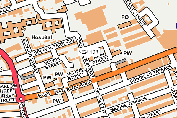
NE24 1DR is located in the Croft electoral ward, within the unitary authority of Northumberland and the English Parliamentary constituency of Blyth Valley. The Sub Integrated Care Board (ICB) Location is NHS North East and North Cumbria ICB - 00L and the police force is Northumbria. This postcode has been in use since June 1997.


GetTheData
Source: OS OpenMap – Local (Ordnance Survey)
Source: OS VectorMap District (Ordnance Survey)
Licence: Open Government Licence (requires attribution)
| Easting | 431146 |
| Northing | 581497 |
| Latitude | 55.126877 |
| Longitude | -1.513113 |
GetTheData
Source: Open Postcode Geo
Licence: Open Government Licence
| Country | England |
| Postcode District | NE24 |
➜ See where NE24 is on a map ➜ Where is Blyth? | |
GetTheData
Source: Land Registry Price Paid Data
Licence: Open Government Licence
Elevation or altitude of NE24 1DR as distance above sea level:
| Metres | Feet | |
|---|---|---|
| Elevation | 10m | 33ft |
Elevation is measured from the approximate centre of the postcode, to the nearest point on an OS contour line from OS Terrain 50, which has contour spacing of ten vertical metres.
➜ How high above sea level am I? Find the elevation of your current position using your device's GPS.
GetTheData
Source: Open Postcode Elevation
Licence: Open Government Licence
| Ward | Croft |
| Constituency | Blyth Valley |
GetTheData
Source: ONS Postcode Database
Licence: Open Government Licence
| Prince Of Wales (Waterloo Road) | Blyth | 88m |
| Prince Of Wales (Bridge Street) | Blyth | 94m |
| Waterloo Road Club (Waterloo Road) | Blyth | 164m |
| Waterloo Road Club (Waterloo Road) | Blyth | 212m |
| Regent Street South End (Regent Street) | Blyth | 312m |
GetTheData
Source: NaPTAN
Licence: Open Government Licence
GetTheData
Source: ONS Postcode Database
Licence: Open Government Licence

➜ Get more ratings from the Food Standards Agency
GetTheData
Source: Food Standards Agency
Licence: FSA terms & conditions
| Last Collection | |||
|---|---|---|---|
| Location | Mon-Fri | Sat | Distance |
| Waterloo Road | 16:45 | 11:00 | 78m |
| Regent Street | 16:30 | 12:15 | 223m |
| Croft Road | 16:45 | 11:00 | 320m |
GetTheData
Source: Dracos
Licence: Creative Commons Attribution-ShareAlike
The below table lists the International Territorial Level (ITL) codes (formerly Nomenclature of Territorial Units for Statistics (NUTS) codes) and Local Administrative Units (LAU) codes for NE24 1DR:
| ITL 1 Code | Name |
|---|---|
| TLC | North East (England) |
| ITL 2 Code | Name |
| TLC2 | Northumberland, and Tyne and Wear |
| ITL 3 Code | Name |
| TLC21 | Northumberland |
| LAU 1 Code | Name |
| E06000057 | Northumberland |
GetTheData
Source: ONS Postcode Directory
Licence: Open Government Licence
The below table lists the Census Output Area (OA), Lower Layer Super Output Area (LSOA), and Middle Layer Super Output Area (MSOA) for NE24 1DR:
| Code | Name | |
|---|---|---|
| OA | E00139525 | |
| LSOA | E01027415 | Northumberland 023B |
| MSOA | E02005710 | Northumberland 023 |
GetTheData
Source: ONS Postcode Directory
Licence: Open Government Licence
| NE24 1EJ | Bowes Court | 32m |
| NE24 1EB | Bowes Street | 32m |
| NE24 1DG | Waterloo Road | 64m |
| NE24 1DP | Wanley Street | 64m |
| NE24 1DF | Waterloo Road | 77m |
| NE24 1ED | Bowes Street | 79m |
| NE24 1DD | Wolsley Road | 99m |
| NE24 1BU | Waterloo Road | 103m |
| NE24 1BE | Bowes Street | 116m |
| NE24 1DH | Waterloo Road | 117m |
GetTheData
Source: Open Postcode Geo; Land Registry Price Paid Data
Licence: Open Government Licence