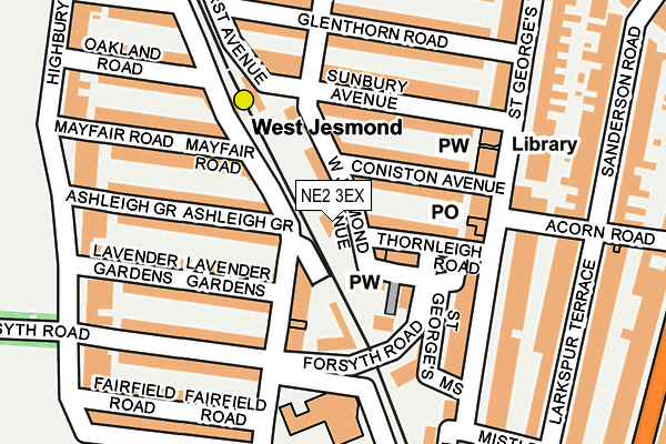
NE2 3EX is located in the North Jesmond electoral ward, within the metropolitan district of Newcastle upon Tyne and the English Parliamentary constituency of Newcastle upon Tyne East. The Sub Integrated Care Board (ICB) Location is NHS North East and North Cumbria ICB - 13T and the police force is Northumbria. This postcode has been in use since January 1980.


GetTheData
Source: OS OpenMap – Local (Ordnance Survey)
Source: OS VectorMap District (Ordnance Survey)
Licence: Open Government Licence (requires attribution)
| Easting | 425138 |
| Northing | 566513 |
| Latitude | 54.992573 |
| Longitude | -1.608641 |
GetTheData
Source: Open Postcode Geo
Licence: Open Government Licence
| Country | England |
| Postcode District | NE2 |
➜ See where NE2 is on a map ➜ Where is Newcastle upon Tyne? | |
GetTheData
Source: Land Registry Price Paid Data
Licence: Open Government Licence
Elevation or altitude of NE2 3EX as distance above sea level:
| Metres | Feet | |
|---|---|---|
| Elevation | 60m | 197ft |
Elevation is measured from the approximate centre of the postcode, to the nearest point on an OS contour line from OS Terrain 50, which has contour spacing of ten vertical metres.
➜ How high above sea level am I? Find the elevation of your current position using your device's GPS.
GetTheData
Source: Open Postcode Elevation
Licence: Open Government Licence
| Ward | North Jesmond |
| Constituency | Newcastle Upon Tyne East |
GetTheData
Source: ONS Postcode Database
Licence: Open Government Licence
| West Jesmond Primary School (Tankerville Terrace) | West Jesmond | 151m |
| Lonsdale Terrace | West Jesmond | 161m |
| Lonsdale Terrace | West Jesmond | 199m |
| Osborne Road-grosvenor Road (Osborne Road) | Jesmond | 324m |
| Osborne Road-mistletoe Road (Osborne Road) | Jesmond | 328m |
| West Jesmond (Tyne And Wear Metro Station) (Brentwood Avenue) | West Jesmond | 163m |
| Ilford Road (Tyne And Wear Metro Station) (Ilford Road) | West Jesmond | 856m |
| Jesmond (Tyne And Wear Metro Station) (Eslington Road) | Jesmond | 1,076m |
| Manors Station | 2.2km |
| Newcastle Station | 2.7km |
| Dunston Station | 5.2km |
GetTheData
Source: NaPTAN
Licence: Open Government Licence
GetTheData
Source: ONS Postcode Database
Licence: Open Government Licence


➜ Get more ratings from the Food Standards Agency
GetTheData
Source: Food Standards Agency
Licence: FSA terms & conditions
| Last Collection | |||
|---|---|---|---|
| Location | Mon-Fri | Sat | Distance |
| Brentwood Avenue | 17:45 | 11:00 | 70m |
| Sunbury Avenue | 17:30 | 11:00 | 128m |
| St George's Terrace | 17:45 | 11:45 | 138m |
GetTheData
Source: Dracos
Licence: Creative Commons Attribution-ShareAlike
The below table lists the International Territorial Level (ITL) codes (formerly Nomenclature of Territorial Units for Statistics (NUTS) codes) and Local Administrative Units (LAU) codes for NE2 3EX:
| ITL 1 Code | Name |
|---|---|
| TLC | North East (England) |
| ITL 2 Code | Name |
| TLC2 | Northumberland, and Tyne and Wear |
| ITL 3 Code | Name |
| TLC22 | Tyneside |
| LAU 1 Code | Name |
| E08000021 | Newcastle upon Tyne |
GetTheData
Source: ONS Postcode Directory
Licence: Open Government Licence
The below table lists the Census Output Area (OA), Lower Layer Super Output Area (LSOA), and Middle Layer Super Output Area (MSOA) for NE2 3EX:
| Code | Name | |
|---|---|---|
| OA | E00042458 | |
| LSOA | E01008369 | Newcastle upon Tyne 013B |
| MSOA | E02001720 | Newcastle upon Tyne 013 |
GetTheData
Source: ONS Postcode Directory
Licence: Open Government Licence
| NE2 3HF | 58m | |
| NE2 3EY | Coniston Avenue | 71m |
| NE2 3ET | Thornleigh Road | 72m |
| NE2 3HB | West Jesmond Avenue | 73m |
| NE2 3DH | Brentwood Avenue | 79m |
| NE2 3HA | Coniston Avenue | 86m |
| NE2 3DF | Jesmond Place | 93m |
| NE2 3EU | St Georges Mews | 105m |
| NE2 3HD | Sunbury Avenue | 107m |
| NE2 3DL | Ashleigh Grove | 125m |
GetTheData
Source: Open Postcode Geo; Land Registry Price Paid Data
Licence: Open Government Licence