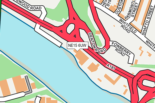
NE15 6UW is located in the Benwell & Scotswood electoral ward, within the metropolitan district of Newcastle upon Tyne and the English Parliamentary constituency of Newcastle upon Tyne Central. The Sub Integrated Care Board (ICB) Location is NHS North East and North Cumbria ICB - 13T and the police force is Northumbria. This postcode has been in use since September 2010.


GetTheData
Source: OS OpenMap – Local (Ordnance Survey)
Source: OS VectorMap District (Ordnance Survey)
Licence: Open Government Licence (requires attribution)
| Easting | 419759 |
| Northing | 563888 |
| Latitude | 54.969232 |
| Longitude | -1.692903 |
GetTheData
Source: Open Postcode Geo
Licence: Open Government Licence
| Country | England |
| Postcode District | NE15 |
➜ See where NE15 is on a map ➜ Where is Newcastle upon Tyne? | |
GetTheData
Source: Land Registry Price Paid Data
Licence: Open Government Licence
Elevation or altitude of NE15 6UW as distance above sea level:
| Metres | Feet | |
|---|---|---|
| Elevation | 10m | 33ft |
Elevation is measured from the approximate centre of the postcode, to the nearest point on an OS contour line from OS Terrain 50, which has contour spacing of ten vertical metres.
➜ How high above sea level am I? Find the elevation of your current position using your device's GPS.
GetTheData
Source: Open Postcode Elevation
Licence: Open Government Licence
| Ward | Benwell & Scotswood |
| Constituency | Newcastle Upon Tyne Central |
GetTheData
Source: ONS Postcode Database
Licence: Open Government Licence
| Scotswood Road-b&q (Scotswood Road) | Scotswood | 256m |
| Denton Road | Scotswood | 260m |
| Scotswood Road-b&q (Scotswood Road) | Scotswood | 274m |
| Scotswood Bridge (Scotswood Road) | Scotswood | 287m |
| Scotswood Bridge (Scotswood Road) | Scotswood | 313m |
| Blaydon Station | 1.3km |
| Metrocentre Station | 2.1km |
| Dunston Station | 3.9km |
GetTheData
Source: NaPTAN
Licence: Open Government Licence
GetTheData
Source: ONS Postcode Database
Licence: Open Government Licence


➜ Get more ratings from the Food Standards Agency
GetTheData
Source: Food Standards Agency
Licence: FSA terms & conditions
| Last Collection | |||
|---|---|---|---|
| Location | Mon-Fri | Sat | Distance |
| Tundry Way | 16:00 | 11:00 | 297m |
| Factory Road | 16:15 | 11:00 | 795m |
| Whiteley Road | 18:45 | 795m | |
GetTheData
Source: Dracos
Licence: Creative Commons Attribution-ShareAlike
The below table lists the International Territorial Level (ITL) codes (formerly Nomenclature of Territorial Units for Statistics (NUTS) codes) and Local Administrative Units (LAU) codes for NE15 6UW:
| ITL 1 Code | Name |
|---|---|
| TLC | North East (England) |
| ITL 2 Code | Name |
| TLC2 | Northumberland, and Tyne and Wear |
| ITL 3 Code | Name |
| TLC22 | Tyneside |
| LAU 1 Code | Name |
| E08000021 | Newcastle upon Tyne |
GetTheData
Source: ONS Postcode Directory
Licence: Open Government Licence
The below table lists the Census Output Area (OA), Lower Layer Super Output Area (LSOA), and Middle Layer Super Output Area (MSOA) for NE15 6UW:
| Code | Name | |
|---|---|---|
| OA | E00042685 | |
| LSOA | E01008415 | Newcastle upon Tyne 025B |
| MSOA | E02001732 | Newcastle upon Tyne 025 |
GetTheData
Source: ONS Postcode Directory
Licence: Open Government Licence
| NE15 6XA | Adamsez East Industrial Estate | 69m |
| NE15 6AN | Whitfield Road | 225m |
| NE15 6AP | Whitfield Road | 242m |
| NE21 5SJ | Tundry Way | 243m |
| NE15 6AR | Heighley Street | 269m |
| NE15 6AS | Ouston Street | 280m |
| NE15 6AT | Parmontley Street | 295m |
| NE15 6AY | Shafto Street | 313m |
| NE21 5NH | Transbritannia Enterprise Park | 406m |
| NE21 5SZ | Chainbridge Road | 460m |
GetTheData
Source: Open Postcode Geo; Land Registry Price Paid Data
Licence: Open Government Licence