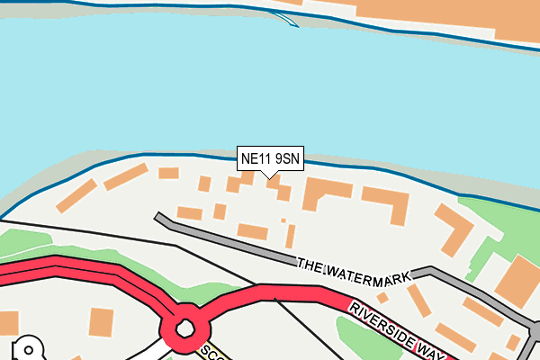
NE11 9SN lies on Staithes in Gateshead. NE11 9SN is located in the Dunston and Teams electoral ward, within the metropolitan district of Gateshead and the English Parliamentary constituency of Gateshead. The Sub Integrated Care Board (ICB) Location is NHS North East and North Cumbria ICB - 13T and the police force is Northumbria. This postcode has been in use since April 2006.


GetTheData
Source: OS OpenMap – Local (Ordnance Survey)
Source: OS VectorMap District (Ordnance Survey)
Licence: Open Government Licence (requires attribution)
| Easting | 420947 |
| Northing | 563277 |
| Latitude | 54.963687 |
| Longitude | -1.674378 |
GetTheData
Source: Open Postcode Geo
Licence: Open Government Licence
| Street | Staithes |
| Town/City | Gateshead |
| Country | England |
| Postcode District | NE11 |
➜ See where NE11 is on a map ➜ Where is Blaydon? | |
GetTheData
Source: Land Registry Price Paid Data
Licence: Open Government Licence
Elevation or altitude of NE11 9SN as distance above sea level:
| Metres | Feet | |
|---|---|---|
| Elevation | 10m | 33ft |
Elevation is measured from the approximate centre of the postcode, to the nearest point on an OS contour line from OS Terrain 50, which has contour spacing of ten vertical metres.
➜ How high above sea level am I? Find the elevation of your current position using your device's GPS.
GetTheData
Source: Open Postcode Elevation
Licence: Open Government Licence
| Ward | Dunston And Teams |
| Constituency | Gateshead |
GetTheData
Source: ONS Postcode Database
Licence: Open Government Licence
| The Watermark (Delta Bank Road) | Metrocentre | 70m |
| Delta Bank Road-works (Delta Bank Road) | Metrocentre | 191m |
| Derwenthaugh Bridge Approach (Scotswood View) | Metrocentre | 222m |
| Derwenthaugh Bridge Approach (Scotswood View) | Metrocentre | 223m |
| Whitehouse Enterprise Centre (Scotswood Road) | Scotswood | 267m |
| Metrocentre Station | 0.8km |
| Blaydon Station | 2.5km |
| Dunston Station | 2.6km |
GetTheData
Source: NaPTAN
Licence: Open Government Licence
GetTheData
Source: ONS Postcode Database
Licence: Open Government Licence


➜ Get more ratings from the Food Standards Agency
GetTheData
Source: Food Standards Agency
Licence: FSA terms & conditions
| Last Collection | |||
|---|---|---|---|
| Location | Mon-Fri | Sat | Distance |
| Delta Bank Road | 18:30 | 11:30 | 334m |
| Delta Bank Road | 19:00 | 334m | |
| Asda Gibside Way | 19:15 | 12:00 | 429m |
GetTheData
Source: Dracos
Licence: Creative Commons Attribution-ShareAlike
The below table lists the International Territorial Level (ITL) codes (formerly Nomenclature of Territorial Units for Statistics (NUTS) codes) and Local Administrative Units (LAU) codes for NE11 9SN:
| ITL 1 Code | Name |
|---|---|
| TLC | North East (England) |
| ITL 2 Code | Name |
| TLC2 | Northumberland, and Tyne and Wear |
| ITL 3 Code | Name |
| TLC22 | Tyneside |
| LAU 1 Code | Name |
| E08000037 | Gateshead |
GetTheData
Source: ONS Postcode Directory
Licence: Open Government Licence
The below table lists the Census Output Area (OA), Lower Layer Super Output Area (LSOA), and Middle Layer Super Output Area (MSOA) for NE11 9SN:
| Code | Name | |
|---|---|---|
| OA | E00170012 | |
| LSOA | E01008209 | Gateshead 007A |
| MSOA | E02001688 | Gateshead 007 |
GetTheData
Source: ONS Postcode Directory
Licence: Open Government Licence
| NE11 9SZ | The Watermark | 74m |
| NE11 9XU | Metro Retail Park | 426m |
| NE11 9DJ | Delta Bank Road | 539m |
| NE15 6BS | Chester Pike | 542m |
| NE11 9XW | Metrocentre | 600m |
| NE15 6BW | Featherwood Avenue | 607m |
| NE15 6BG | Bellshiel Grove | 628m |
| NE15 6BF | Birdhope Close | 648m |
| NE15 6AZ | Featherwood Avenue | 675m |
| NE15 6JE | Armstrong Road | 701m |
GetTheData
Source: Open Postcode Geo; Land Registry Price Paid Data
Licence: Open Government Licence