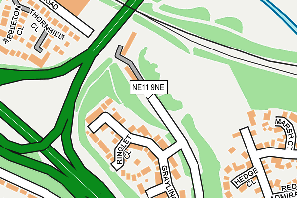
NE11 9NE lies on Vance Business Park in Gateshead. NE11 9NE is located in the Lobley Hill and Bensham electoral ward, within the metropolitan district of Gateshead and the English Parliamentary constituency of Gateshead. The Sub Integrated Care Board (ICB) Location is NHS North East and North Cumbria ICB - 13T and the police force is Northumbria. This postcode has been in use since August 1992.


GetTheData
Source: OS OpenMap – Local (Ordnance Survey)
Source: OS VectorMap District (Ordnance Survey)
Licence: Open Government Licence (requires attribution)
| Easting | 423560 |
| Northing | 561520 |
| Latitude | 54.947790 |
| Longitude | -1.633724 |
GetTheData
Source: Open Postcode Geo
Licence: Open Government Licence
| Street | Vance Business Park |
| Town/City | Gateshead |
| Country | England |
| Postcode District | NE11 |
➜ See where NE11 is on a map ➜ Where is Gateshead? | |
GetTheData
Source: Land Registry Price Paid Data
Licence: Open Government Licence
Elevation or altitude of NE11 9NE as distance above sea level:
| Metres | Feet | |
|---|---|---|
| Elevation | 10m | 33ft |
Elevation is measured from the approximate centre of the postcode, to the nearest point on an OS contour line from OS Terrain 50, which has contour spacing of ten vertical metres.
➜ How high above sea level am I? Find the elevation of your current position using your device's GPS.
GetTheData
Source: Open Postcode Elevation
Licence: Open Government Licence
| Ward | Lobley Hill And Bensham |
| Constituency | Gateshead |
GetTheData
Source: ONS Postcode Database
Licence: Open Government Licence
| Derwentwater Road-teams Bridge (Derwentwater Road) | Teams | 296m |
| Derwentwater Road-teams Bridge (Derwentwater Road) | Teams | 297m |
| Malvern Gardens-cotswold Gardens (Malvern Gardens) | Lobley Hill | 403m |
| Ellison Road-catholic Church (Ellison Road) | Teams | 412m |
| Cotswold Gardens-moorfoot Gardens (Cotswold Gardens) | Lobley Hill | 417m |
| Dunston Station | 0.6km |
| Metrocentre Station | 2.4km |
| Newcastle Station | 2.5km |
GetTheData
Source: NaPTAN
Licence: Open Government Licence
| Median download speed | 14.7Mbps |
| Average download speed | 15.0Mbps |
| Maximum download speed | 19.06Mbps |
| Median upload speed | 1.2Mbps |
| Average upload speed | 1.1Mbps |
| Maximum upload speed | 1.26Mbps |
GetTheData
Source: Ofcom
Licence: Ofcom Terms of Use (requires attribution)
Estimated total energy consumption in NE11 9NE by fuel type, 2015.
| Consumption (kWh) | 151,084 |
|---|---|
| Meter count | 8 |
| Mean (kWh/meter) | 18,886 |
| Median (kWh/meter) | 18,335 |
GetTheData
Source: Postcode level gas estimates: 2015 (experimental)
Source: Postcode level electricity estimates: 2015 (experimental)
Licence: Open Government Licence
GetTheData
Source: ONS Postcode Database
Licence: Open Government Licence


➜ Get more ratings from the Food Standards Agency
GetTheData
Source: Food Standards Agency
Licence: FSA terms & conditions
| Last Collection | |||
|---|---|---|---|
| Location | Mon-Fri | Sat | Distance |
| Knightside Gardens | 17:30 | 11:30 | 465m |
| Redheugh Court | 17:30 | 12:15 | 562m |
| Malvern Gardens | 17:45 | 12:00 | 565m |
GetTheData
Source: Dracos
Licence: Creative Commons Attribution-ShareAlike
The below table lists the International Territorial Level (ITL) codes (formerly Nomenclature of Territorial Units for Statistics (NUTS) codes) and Local Administrative Units (LAU) codes for NE11 9NE:
| ITL 1 Code | Name |
|---|---|
| TLC | North East (England) |
| ITL 2 Code | Name |
| TLC2 | Northumberland, and Tyne and Wear |
| ITL 3 Code | Name |
| TLC22 | Tyneside |
| LAU 1 Code | Name |
| E08000037 | Gateshead |
GetTheData
Source: ONS Postcode Directory
Licence: Open Government Licence
The below table lists the Census Output Area (OA), Lower Layer Super Output Area (LSOA), and Middle Layer Super Output Area (MSOA) for NE11 9NE:
| Code | Name | |
|---|---|---|
| OA | E00041877 | |
| LSOA | E01008260 | Gateshead 019B |
| MSOA | E02001700 | Gateshead 019 |
GetTheData
Source: ONS Postcode Directory
Licence: Open Government Licence
| NE11 9SH | Thornhill Close | 157m |
| NE11 9NF | Ringlet Close | 211m |
| NE11 9ND | Grayling Road | 215m |
| NE11 9SG | Appleton Close | 248m |
| NE11 9NG | Skipper Close | 297m |
| NE11 9TH | Rochester Gardens | 304m |
| NE11 9UG | Hedge Close | 321m |
| NE11 9NJ | Coppers Close | 327m |
| NE11 9TD | Marsh Court | 338m |
| NE11 9JX | Chiltern Gardens | 342m |
GetTheData
Source: Open Postcode Geo; Land Registry Price Paid Data
Licence: Open Government Licence