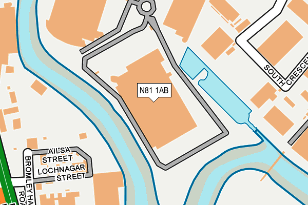
N81 1AB is located in the Canning Town North electoral ward, within the London borough of Newham and the English Parliamentary constituency of West Ham. The Sub Integrated Care Board (ICB) Location is NHS North East London ICB - A3A8R and the police force is Metropolitan Police. This postcode has been in use since January 2015.


GetTheData
Source: OS OpenMap – Local (Ordnance Survey)
Source: OS VectorMap District (Ordnance Survey)
Licence: Open Government Licence (requires attribution)
| Easting | 538486 |
| Northing | 181894 |
| Latitude | 51.518997 |
| Longitude | -0.005422 |
GetTheData
Source: Open Postcode Geo
Licence: Open Government Licence
| Country | England |
| Postcode District | N81 |
➜ Where is London? | |
GetTheData
Source: Land Registry Price Paid Data
Licence: Open Government Licence
Elevation or altitude of N81 1AB as distance above sea level:
| Metres | Feet | |
|---|---|---|
| Elevation | 0m | 0ft |
Elevation is measured from the approximate centre of the postcode, to the nearest point on an OS contour line from OS Terrain 50, which has contour spacing of ten vertical metres.
➜ How high above sea level am I? Find the elevation of your current position using your device's GPS.
GetTheData
Source: Open Postcode Elevation
Licence: Open Government Licence
| Ward | Canning Town North |
| Constituency | West Ham |
GetTheData
Source: ONS Postcode Database
Licence: Open Government Licence
| Twelvetrees Crescent | Bromley | 219m |
| Lochnagar Street (Blackwall Tunnel Northern Approach) | Bromley | 307m |
| St Leonard's Wharf (Blackwall Tunnel Northern Approach) | Bromley | 335m |
| St Leonards Wharfgillender St (Gillender Street) | Bromley | 384m |
| Poplar Baptist Church (Zetland Street) | Bromley | 395m |
| Star Lane Dlr Station | Canning Town | 694m |
| Langdon Park Dlr Station (Hay Currie Street) | Poplar | 740m |
| Bromley-by-bow Underground Station | Bromley | 776m |
| Devons Road Dlr Station (Devons Road) | Devons Road | 940m |
| All Saints Dlr Station (East India Dock Road) | All Saints | 1,038m |
| West Ham Station | 1.3km |
| Limehouse Station | 2.5km |
| Stratford (London) Station | 2.6km |
GetTheData
Source: NaPTAN
Licence: Open Government Licence
GetTheData
Source: ONS Postcode Database
Licence: Open Government Licence


➜ Get more ratings from the Food Standards Agency
GetTheData
Source: Food Standards Agency
Licence: FSA terms & conditions
| Last Collection | |||
|---|---|---|---|
| Location | Mon-Fri | Sat | Distance |
| East London Mail Centre | 19:30 | 145m | |
| East London Mail Centre | 19:30 | 11:30 | 146m |
| East London Mail Centre | 19:30 | 11:30 | 160m |
GetTheData
Source: Dracos
Licence: Creative Commons Attribution-ShareAlike
The below table lists the International Territorial Level (ITL) codes (formerly Nomenclature of Territorial Units for Statistics (NUTS) codes) and Local Administrative Units (LAU) codes for N81 1AB:
| ITL 1 Code | Name |
|---|---|
| TLI | London |
| ITL 2 Code | Name |
| TLI4 | Inner London - East |
| ITL 3 Code | Name |
| TLI41 | Hackney and Newham |
| LAU 1 Code | Name |
| E09000025 | Newham |
GetTheData
Source: ONS Postcode Directory
Licence: Open Government Licence
The below table lists the Census Output Area (OA), Lower Layer Super Output Area (LSOA), and Middle Layer Super Output Area (MSOA) for N81 1AB:
| Code | Name | |
|---|---|---|
| OA | E00017700 | |
| LSOA | E01003497 | Newham 034A |
| MSOA | E02000747 | Newham 034 |
GetTheData
Source: ONS Postcode Directory
Licence: Open Government Licence
| E14 0GY | Leven Road | 283m |
| E14 6RN | Gillender Street | 291m |
| E14 0LJ | Leven Road | 302m |
| E14 0HX | St Ives Place | 325m |
| E14 0LQ | Nairn Street | 335m |
| E14 0GU | St Ives Place | 348m |
| E14 0LL | Leven Road | 370m |
| E14 0NG | Abbott Road | 372m |
| E14 6QR | Teviot Street | 376m |
| E14 6QS | Teviot Street | 378m |
GetTheData
Source: Open Postcode Geo; Land Registry Price Paid Data
Licence: Open Government Licence