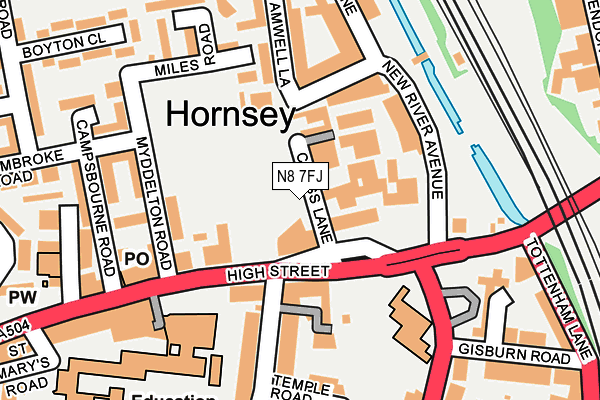
N8 7FJ is located in the Hornsey electoral ward, within the London borough of Haringey and the English Parliamentary constituency of Hornsey and Wood Green. The Sub Integrated Care Board (ICB) Location is NHS North Central London ICB - 93C and the police force is Metropolitan Police. This postcode has been in use since May 2018.


GetTheData
Source: OS OpenMap – Local (Ordnance Survey)
Source: OS VectorMap District (Ordnance Survey)
Licence: Open Government Licence (requires attribution)
| Easting | 530586 |
| Northing | 189408 |
| Latitude | 51.588404 |
| Longitude | -0.116402 |
GetTheData
Source: Open Postcode Geo
Licence: Open Government Licence
| Country | England |
| Postcode District | N8 |
➜ See where N8 is on a map | |
GetTheData
Source: Land Registry Price Paid Data
Licence: Open Government Licence
| Ward | Hornsey |
| Constituency | Hornsey And Wood Green |
GetTheData
Source: ONS Postcode Database
Licence: Open Government Licence
| Myddelton Road (Hornsey High Street) | Hornsey | 142m |
| Tottenham Lane Turnpike Lane (High Street Hornsey) | Hornsey | 176m |
| Myddelton Road (Hornsey High Street) | Hornsey | 182m |
| Tottenham Lane Turnpike Lane (Hornsey Road) | Hornsey | 192m |
| Wightman Road Turnpike Lane (Turnpike Lane) | Hornsey | 361m |
| Turnpike Lane Underground Station | Turnpike Lane | 957m |
| Wood Green Underground Station | Wood Green | 1,107m |
| Hornsey Station | 0.4km |
| Alexandra Palace Station | 1.1km |
| Harringay Station | 1.5km |
GetTheData
Source: NaPTAN
Licence: Open Government Licence
| Percentage of properties with Next Generation Access | 100.0% |
| Percentage of properties with Superfast Broadband | 100.0% |
| Percentage of properties with Ultrafast Broadband | 100.0% |
| Percentage of properties with Full Fibre Broadband | 100.0% |
Superfast Broadband is between 30Mbps and 300Mbps
Ultrafast Broadband is > 300Mbps
| Percentage of properties unable to receive 2Mbps | 0.0% |
| Percentage of properties unable to receive 5Mbps | 0.0% |
| Percentage of properties unable to receive 10Mbps | 0.0% |
| Percentage of properties unable to receive 30Mbps | 0.0% |
GetTheData
Source: Ofcom
Licence: Ofcom Terms of Use (requires attribution)
GetTheData
Source: ONS Postcode Database
Licence: Open Government Licence


➜ Get more ratings from the Food Standards Agency
GetTheData
Source: Food Standards Agency
Licence: FSA terms & conditions
| Last Collection | |||
|---|---|---|---|
| Location | Mon-Fri | Sat | Distance |
| Hillfield Avenue/Temple Road | 17:30 | 12:00 | 195m |
| 24 High Street | 17:30 | 12:00 | 317m |
| Hornsey Delivery Office | 17:30 | 12:00 | 380m |
GetTheData
Source: Dracos
Licence: Creative Commons Attribution-ShareAlike
The below table lists the International Territorial Level (ITL) codes (formerly Nomenclature of Territorial Units for Statistics (NUTS) codes) and Local Administrative Units (LAU) codes for N8 7FJ:
| ITL 1 Code | Name |
|---|---|
| TLI | London |
| ITL 2 Code | Name |
| TLI4 | Inner London - East |
| ITL 3 Code | Name |
| TLI43 | Haringey and Islington |
| LAU 1 Code | Name |
| E09000014 | Haringey |
GetTheData
Source: ONS Postcode Directory
Licence: Open Government Licence
The below table lists the Census Output Area (OA), Lower Layer Super Output Area (LSOA), and Middle Layer Super Output Area (MSOA) for N8 7FJ:
| Code | Name | |
|---|---|---|
| OA | E00170314 | |
| LSOA | E01033085 | Haringey 020E |
| MSOA | E02000416 | Haringey 020 |
GetTheData
Source: ONS Postcode Directory
Licence: Open Government Licence
| N8 7QB | High Street | 42m |
| N8 7QG | High Street | 42m |
| N8 7NT | High Street | 88m |
| N8 7NU | High Street | 110m |
| N8 7QF | New River Avenue | 121m |
| N8 7BF | Hillfield Mews | 123m |
| N8 7PW | Myddelton Road | 124m |
| N8 7QE | New River Avenue | 129m |
| N8 7SE | Moselle Close | 134m |
| N8 7DU | Hillfield Avenue | 150m |
GetTheData
Source: Open Postcode Geo; Land Registry Price Paid Data
Licence: Open Government Licence