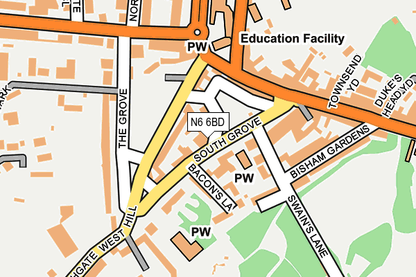
N6 6BD lies on Pond Square in London. N6 6BD is located in the Highgate electoral ward, within the London borough of Camden and the English Parliamentary constituency of Holborn and St Pancras. The Sub Integrated Care Board (ICB) Location is NHS North Central London ICB - 93C and the police force is Metropolitan Police. This postcode has been in use since January 1980.


GetTheData
Source: OS OpenMap – Local (Ordnance Survey)
Source: OS VectorMap District (Ordnance Survey)
Licence: Open Government Licence (requires attribution)
| Easting | 528327 |
| Northing | 187331 |
| Latitude | 51.570254 |
| Longitude | -0.149775 |
GetTheData
Source: Open Postcode Geo
Licence: Open Government Licence
| Street | Pond Square |
| Town/City | London |
| Country | England |
| Postcode District | N6 |
➜ See where N6 is on a map ➜ Where is London? | |
GetTheData
Source: Land Registry Price Paid Data
Licence: Open Government Licence
Elevation or altitude of N6 6BD as distance above sea level:
| Metres | Feet | |
|---|---|---|
| Elevation | 130m | 427ft |
Elevation is measured from the approximate centre of the postcode, to the nearest point on an OS contour line from OS Terrain 50, which has contour spacing of ten vertical metres.
➜ How high above sea level am I? Find the elevation of your current position using your device's GPS.
GetTheData
Source: Open Postcode Elevation
Licence: Open Government Licence
| Ward | Highgate |
| Constituency | Holborn And St Pancras |
GetTheData
Source: ONS Postcode Database
Licence: Open Government Licence
| Pond Square | Highgate | 79m |
| South Grove (N6) (Highgate High Street) | Dartmouth Park | 98m |
| South Grove (N6) (South Grove) | Dartmouth Park | 114m |
| South Grove (N6) (Highgate High Street) | Dartmouth Park | 132m |
| St Michael's Church | Dartmouth Park | 170m |
| Highgate Underground Station | Highgate | 854m |
| Archway Underground Station | Archway | 1,165m |
| Tufnell Park Underground Station | Tufnell Park | 1,689m |
| Upper Holloway Station | 1.6km |
| Gospel Oak Station | 1.7km |
| Hampstead Heath Station | 2km |
GetTheData
Source: NaPTAN
Licence: Open Government Licence
| Percentage of properties with Next Generation Access | 100.0% |
| Percentage of properties with Superfast Broadband | 100.0% |
| Percentage of properties with Ultrafast Broadband | 100.0% |
| Percentage of properties with Full Fibre Broadband | 0.0% |
Superfast Broadband is between 30Mbps and 300Mbps
Ultrafast Broadband is > 300Mbps
| Percentage of properties unable to receive 2Mbps | 0.0% |
| Percentage of properties unable to receive 5Mbps | 0.0% |
| Percentage of properties unable to receive 10Mbps | 0.0% |
| Percentage of properties unable to receive 30Mbps | 0.0% |
GetTheData
Source: Ofcom
Licence: Ofcom Terms of Use (requires attribution)
GetTheData
Source: ONS Postcode Database
Licence: Open Government Licence


➜ Get more ratings from the Food Standards Agency
GetTheData
Source: Food Standards Agency
Licence: FSA terms & conditions
| Last Collection | |||
|---|---|---|---|
| Location | Mon-Fri | Sat | Distance |
| Hampstead Lane/The Grove | 17:30 | 12:00 | 181m |
| Dyne House/Southwood Lane | 17:30 | 12:00 | 186m |
| 7 Highgate High Street | 17:30 | 12:00 | 258m |
GetTheData
Source: Dracos
Licence: Creative Commons Attribution-ShareAlike
The below table lists the International Territorial Level (ITL) codes (formerly Nomenclature of Territorial Units for Statistics (NUTS) codes) and Local Administrative Units (LAU) codes for N6 6BD:
| ITL 1 Code | Name |
|---|---|
| TLI | London |
| ITL 2 Code | Name |
| TLI3 | Inner London - West |
| ITL 3 Code | Name |
| TLI31 | Camden and City of London |
| LAU 1 Code | Name |
| E09000007 | Camden |
GetTheData
Source: ONS Postcode Directory
Licence: Open Government Licence
The below table lists the Census Output Area (OA), Lower Layer Super Output Area (LSOA), and Middle Layer Super Output Area (MSOA) for N6 6BD:
| Code | Name | |
|---|---|---|
| OA | E00004494 | |
| LSOA | E01000913 | Camden 001E |
| MSOA | E02000166 | Camden 001 |
GetTheData
Source: ONS Postcode Directory
Licence: Open Government Licence
| N6 6BE | South Grove | 16m |
| N6 6BT | Cobble Mews | 27m |
| N6 6BU | Highgate West Hill | 46m |
| N6 6BJ | South Grove | 55m |
| N6 6BH | St Michaels Terrace | 57m |
| N6 6BL | Bacons Lane | 80m |
| N6 6DA | Highgate West Hill | 81m |
| N6 6BB | South Grove | 84m |
| N6 6BA | Pond Square | 86m |
| N6 5JX | Highgate High Street | 89m |
GetTheData
Source: Open Postcode Geo; Land Registry Price Paid Data
Licence: Open Government Licence