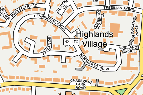
N21 1TQ lies on Pennington Drive in London. N21 1TQ is located in the Oakwood electoral ward, within the London borough of Enfield and the English Parliamentary constituency of Enfield, Southgate. The Sub Integrated Care Board (ICB) Location is NHS North Central London ICB - 93C and the police force is Metropolitan Police. This postcode has been in use since May 2019.


GetTheData
Source: OS OpenMap – Local (Ordnance Survey)
Source: OS VectorMap District (Ordnance Survey)
Licence: Open Government Licence (requires attribution)
| Easting | 530609 |
| Northing | 195718 |
| Latitude | 51.645103 |
| Longitude | -0.113719 |
GetTheData
Source: Open Postcode Geo
Licence: Open Government Licence
| Street | Pennington Drive |
| Town/City | London |
| Country | England |
| Postcode District | N21 |
➜ See where N21 is on a map ➜ Where is London? | |
GetTheData
Source: Land Registry Price Paid Data
Licence: Open Government Licence
| Ward | Oakwood |
| Constituency | Enfield, Southgate |
GetTheData
Source: ONS Postcode Database
Licence: Open Government Licence
| Blackwell Close (Pennington Drive) | Oakwood | 113m |
| Pennington Drive | Grange Park | 126m |
| Rutherford Court (Newsholme Avenue) | Grange Park | 132m |
| Highlands Avenue Sainsbury's | Grange Park | 239m |
| Highlands Village Elizabeth Lodge (Pennington Drive) | Oakwood | 242m |
| Oakwood Underground Station | Oakwood | 1,308m |
| Southgate Underground Station | Southgate | 1,724m |
| Grange Park Station | 1.2km |
| Winchmore Hill Station | 1.5km |
| Enfield Chase Station | 1.8km |
GetTheData
Source: NaPTAN
Licence: Open Government Licence
| Percentage of properties with Next Generation Access | 100.0% |
| Percentage of properties with Superfast Broadband | 100.0% |
| Percentage of properties with Ultrafast Broadband | 0.0% |
| Percentage of properties with Full Fibre Broadband | 0.0% |
Superfast Broadband is between 30Mbps and 300Mbps
Ultrafast Broadband is > 300Mbps
| Percentage of properties unable to receive 2Mbps | 0.0% |
| Percentage of properties unable to receive 5Mbps | 0.0% |
| Percentage of properties unable to receive 10Mbps | 0.0% |
| Percentage of properties unable to receive 30Mbps | 0.0% |
GetTheData
Source: Ofcom
Licence: Ofcom Terms of Use (requires attribution)
GetTheData
Source: ONS Postcode Database
Licence: Open Government Licence


➜ Get more ratings from the Food Standards Agency
GetTheData
Source: Food Standards Agency
Licence: FSA terms & conditions
| Last Collection | |||
|---|---|---|---|
| Location | Mon-Fri | Sat | Distance |
| 8 Chaseville Park Road | 17:30 | 12:00 | 150m |
| Worlds End Lane | 17:30 | 12:00 | 298m |
| Hollyhill/Eversley Pk Road | 17:30 | 12:00 | 436m |
GetTheData
Source: Dracos
Licence: Creative Commons Attribution-ShareAlike
The below table lists the International Territorial Level (ITL) codes (formerly Nomenclature of Territorial Units for Statistics (NUTS) codes) and Local Administrative Units (LAU) codes for N21 1TQ:
| ITL 1 Code | Name |
|---|---|
| TLI | London |
| ITL 2 Code | Name |
| TLI5 | Outer London - East and North East |
| ITL 3 Code | Name |
| TLI54 | Enfield |
| LAU 1 Code | Name |
| E09000010 | Enfield |
GetTheData
Source: ONS Postcode Directory
Licence: Open Government Licence
The below table lists the Census Output Area (OA), Lower Layer Super Output Area (LSOA), and Middle Layer Super Output Area (MSOA) for N21 1TQ:
| Code | Name | |
|---|---|---|
| OA | E00007540 | |
| LSOA | E01001522 | Enfield 019B |
| MSOA | E02000295 | Enfield 019 |
GetTheData
Source: ONS Postcode Directory
Licence: Open Government Licence
| N21 1TP | Pennington Drive | 40m |
| N21 1TN | Pennington Drive | 42m |
| N21 1SL | Banting Drive | 47m |
| N21 1TB | Pennington Drive | 47m |
| N21 1TY | Pennington Drive | 47m |
| N21 1TX | Newsholme Drive | 57m |
| N21 1TS | Kaplan Drive | 65m |
| N21 1TU | Pennington Drive | 65m |
| N21 1UF | Newsholme Drive | 70m |
| N21 1TT | Treves Close | 74m |
GetTheData
Source: Open Postcode Geo; Land Registry Price Paid Data
Licence: Open Government Licence