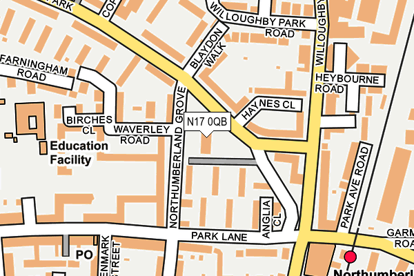
N17 0QB lies on Northumberland Park in London. N17 0QB is located in the Northumberland Park electoral ward, within the London borough of Haringey and the English Parliamentary constituency of Tottenham. The Sub Integrated Care Board (ICB) Location is NHS North Central London ICB - 93C and the police force is Metropolitan Police. This postcode has been in use since January 1980.


GetTheData
Source: OS OpenMap – Local (Ordnance Survey)
Source: OS VectorMap District (Ordnance Survey)
Licence: Open Government Licence (requires attribution)
| Easting | 534667 |
| Northing | 191203 |
| Latitude | 51.603572 |
| Longitude | -0.056867 |
GetTheData
Source: Open Postcode Geo
Licence: Open Government Licence
| Street | Northumberland Park |
| Town/City | London |
| Country | England |
| Postcode District | N17 |
➜ See where N17 is on a map | |
GetTheData
Source: Land Registry Price Paid Data
Licence: Open Government Licence
Elevation or altitude of N17 0QB as distance above sea level:
| Metres | Feet | |
|---|---|---|
| Elevation | 10m | 33ft |
Elevation is measured from the approximate centre of the postcode, to the nearest point on an OS contour line from OS Terrain 50, which has contour spacing of ten vertical metres.
➜ How high above sea level am I? Find the elevation of your current position using your device's GPS.
GetTheData
Source: Open Postcode Elevation
Licence: Open Government Licence
| Ward | Northumberland Park |
| Constituency | Tottenham |
GetTheData
Source: ONS Postcode Database
Licence: Open Government Licence
| Northumberland Park | Northumberland Park | 95m |
| Northumberland Park | Northumberland Park | 151m |
| Northumberland Park | Northumberland Park | 153m |
| Scotswood Walk (Northumberland Park) | Northumberland Park | 158m |
| Scotswood Walk (Northumberland Park) | Northumberland Park | 263m |
| Northumberland Park Station | 0.3km |
| White Hart Lane Station | 1km |
| Angel Road Station | 1.1km |
GetTheData
Source: NaPTAN
Licence: Open Government Licence
| Median download speed | 100.0Mbps |
| Average download speed | 111.6Mbps |
| Maximum download speed | 350.00Mbps |
| Median upload speed | 10.0Mbps |
| Average upload speed | 11.6Mbps |
| Maximum upload speed | 20.00Mbps |
GetTheData
Source: Ofcom
Licence: Ofcom Terms of Use (requires attribution)
Estimated total energy consumption in N17 0QB by fuel type, 2015.
| Consumption (kWh) | 449,131 |
|---|---|
| Meter count | 63 |
| Mean (kWh/meter) | 7,129 |
| Median (kWh/meter) | 6,369 |
| Consumption (kWh) | 143,514 |
|---|---|
| Meter count | 62 |
| Mean (kWh/meter) | 2,315 |
| Median (kWh/meter) | 2,091 |
GetTheData
Source: Postcode level gas estimates: 2015 (experimental)
Source: Postcode level electricity estimates: 2015 (experimental)
Licence: Open Government Licence
GetTheData
Source: ONS Postcode Database
Licence: Open Government Licence


➜ Get more ratings from the Food Standards Agency
GetTheData
Source: Food Standards Agency
Licence: FSA terms & conditions
| Last Collection | |||
|---|---|---|---|
| Location | Mon-Fri | Sat | Distance |
| Northumberland Pk/ | 17:30 | 12:00 | 203m |
| 142 Park Lane | 17:30 | 12:00 | 214m |
| Asplins Road/Shelbourne Road | 17:30 | 12:00 | 341m |
GetTheData
Source: Dracos
Licence: Creative Commons Attribution-ShareAlike
| Risk of N17 0QB flooding from rivers and sea | Low |
| ➜ N17 0QB flood map | |
GetTheData
Source: Open Flood Risk by Postcode
Licence: Open Government Licence
The below table lists the International Territorial Level (ITL) codes (formerly Nomenclature of Territorial Units for Statistics (NUTS) codes) and Local Administrative Units (LAU) codes for N17 0QB:
| ITL 1 Code | Name |
|---|---|
| TLI | London |
| ITL 2 Code | Name |
| TLI4 | Inner London - East |
| ITL 3 Code | Name |
| TLI43 | Haringey and Islington |
| LAU 1 Code | Name |
| E09000014 | Haringey |
GetTheData
Source: ONS Postcode Directory
Licence: Open Government Licence
The below table lists the Census Output Area (OA), Lower Layer Super Output Area (LSOA), and Middle Layer Super Output Area (MSOA) for N17 0QB:
| Code | Name | |
|---|---|---|
| OA | E00010224 | |
| LSOA | E01002039 | Haringey 002C |
| MSOA | E02000398 | Haringey 002 |
GetTheData
Source: ONS Postcode Directory
Licence: Open Government Licence
| N17 0QA | Northumberland Park | 0m |
| N17 0QE | Northumberland Park | 59m |
| N17 0QD | Northumberland Park | 66m |
| N17 0RB | Northumberland Park | 70m |
| N17 0PY | Northumberland Grove | 73m |
| N17 0QG | Northumberland Park | 79m |
| N17 0RD | Haynes Close | 89m |
| N17 0PZ | Northumberland Grove | 92m |
| N17 0HR | Park Lane | 107m |
| N17 0PX | Waverley Road | 109m |
GetTheData
Source: Open Postcode Geo; Land Registry Price Paid Data
Licence: Open Government Licence