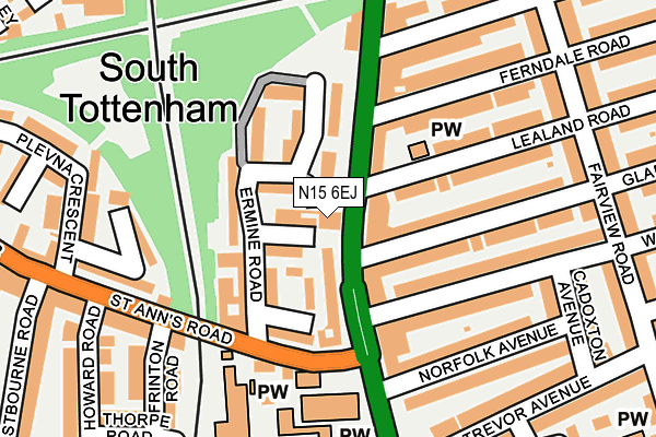
N15 6EJ is located in the Seven Sisters electoral ward, within the London borough of Haringey and the English Parliamentary constituency of Tottenham. The Sub Integrated Care Board (ICB) Location is NHS North Central London ICB - 93C and the police force is Metropolitan Police. This postcode has been in use since April 2012.


GetTheData
Source: OS OpenMap – Local (Ordnance Survey)
Source: OS VectorMap District (Ordnance Survey)
Licence: Open Government Licence (requires attribution)
| Easting | 533593 |
| Northing | 188368 |
| Latitude | 51.578351 |
| Longitude | -0.073444 |
GetTheData
Source: Open Postcode Geo
Licence: Open Government Licence
| Country | England |
| Postcode District | N15 |
➜ See where N15 is on a map | |
GetTheData
Source: Land Registry Price Paid Data
Licence: Open Government Licence
Elevation or altitude of N15 6EJ as distance above sea level:
| Metres | Feet | |
|---|---|---|
| Elevation | 20m | 66ft |
Elevation is measured from the approximate centre of the postcode, to the nearest point on an OS contour line from OS Terrain 50, which has contour spacing of ten vertical metres.
➜ How high above sea level am I? Find the elevation of your current position using your device's GPS.
GetTheData
Source: Open Postcode Elevation
Licence: Open Government Licence
| Ward | Seven Sisters |
| Constituency | Tottenham |
GetTheData
Source: ONS Postcode Database
Licence: Open Government Licence
| Lealand Road (High Road) | South Tottenham | 31m |
| Gladesmore Road High Road | South Tottenham | 68m |
| St Ann's Road High Road (High Road) | South Tottenham | 75m |
| Wargrave Avenue | South Tottenham | 105m |
| Ermine Road St. Ignatius Church (St Anns Road) | South Tottenham | 128m |
| Seven Sisters Underground Station | Seven Sisters | 557m |
| Tottenham Hale Underground Station | Tottenham Hale | 1,419m |
| South Tottenham Station | 0.2km |
| Seven Sisters Station | 0.5km |
| Stamford Hill Station | 0.5km |
GetTheData
Source: NaPTAN
Licence: Open Government Licence
GetTheData
Source: ONS Postcode Database
Licence: Open Government Licence


➜ Get more ratings from the Food Standards Agency
GetTheData
Source: Food Standards Agency
Licence: FSA terms & conditions
| Last Collection | |||
|---|---|---|---|
| Location | Mon-Fri | Sat | Distance |
| 136 High Road | 17:30 | 12:00 | 134m |
| Wargrave Avenue/Cadoxton Avenu | 17:30 | 12:00 | 214m |
| Eastbourne Road/St Anns Road | 17:30 | 12:00 | 279m |
GetTheData
Source: Dracos
Licence: Creative Commons Attribution-ShareAlike
The below table lists the International Territorial Level (ITL) codes (formerly Nomenclature of Territorial Units for Statistics (NUTS) codes) and Local Administrative Units (LAU) codes for N15 6EJ:
| ITL 1 Code | Name |
|---|---|
| TLI | London |
| ITL 2 Code | Name |
| TLI4 | Inner London - East |
| ITL 3 Code | Name |
| TLI43 | Haringey and Islington |
| LAU 1 Code | Name |
| E09000014 | Haringey |
GetTheData
Source: ONS Postcode Directory
Licence: Open Government Licence
The below table lists the Census Output Area (OA), Lower Layer Super Output Area (LSOA), and Middle Layer Super Output Area (MSOA) for N15 6EJ:
| Code | Name | |
|---|---|---|
| OA | E00010304 | |
| LSOA | E01002051 | Haringey 029B |
| MSOA | E02000425 | Haringey 029 |
GetTheData
Source: ONS Postcode Directory
Licence: Open Government Licence
| N15 6DR | Sherboro Road | 36m |
| N15 6JR | High Road | 50m |
| N15 6DL | High Road | 52m |
| N15 6DE | Ermine Road | 81m |
| N15 6DB | Ermine Road | 90m |
| N15 6DD | Ermine Road | 104m |
| N15 6DT | St Anns Road | 107m |
| N15 6JU | High Road | 110m |
| N15 6DP | Westcott Close | 116m |
| N15 6TA | Gladesmore Road | 127m |
GetTheData
Source: Open Postcode Geo; Land Registry Price Paid Data
Licence: Open Government Licence