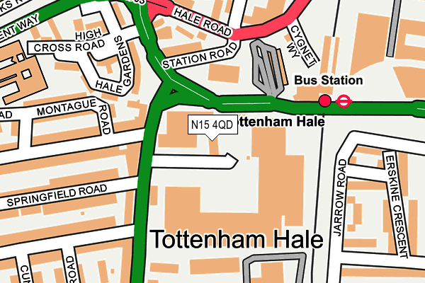
N15 4QD is located in the South Tottenham electoral ward, within the London borough of Haringey and the English Parliamentary constituency of Tottenham. The Sub Integrated Care Board (ICB) Location is NHS North Central London ICB - 93C and the police force is Metropolitan Police. This postcode has been in use since August 1993.


GetTheData
Source: OS OpenMap – Local (Ordnance Survey)
Source: OS VectorMap District (Ordnance Survey)
Licence: Open Government Licence (requires attribution)
| Easting | 534338 |
| Northing | 189417 |
| Latitude | 51.587603 |
| Longitude | -0.062273 |
GetTheData
Source: Open Postcode Geo
Licence: Open Government Licence
| Country | England |
| Postcode District | N15 |
➜ See where N15 is on a map | |
GetTheData
Source: Land Registry Price Paid Data
Licence: Open Government Licence
Elevation or altitude of N15 4QD as distance above sea level:
| Metres | Feet | |
|---|---|---|
| Elevation | 10m | 33ft |
Elevation is measured from the approximate centre of the postcode, to the nearest point on an OS contour line from OS Terrain 50, which has contour spacing of ten vertical metres.
➜ How high above sea level am I? Find the elevation of your current position using your device's GPS.
GetTheData
Source: Open Postcode Elevation
Licence: Open Government Licence
| Ward | South Tottenham |
| Constituency | Tottenham |
GetTheData
Source: ONS Postcode Database
Licence: Open Government Licence
| Tottenham Hale Retail Park | Tottenham Hale | 98m |
| Tottenham Hale Bus Station | Tottenham Hale | 107m |
| Tottenham Hale Bus Station | Tottenham Hale | 119m |
| Tottenham Hale Bus Station | Tottenham Hale | 127m |
| Tottenham Hale Bus Station | Tottenham Hale | 132m |
| Tottenham Hale Underground Station | Tottenham Hale | 153m |
| Seven Sisters Underground Station | Seven Sisters | 857m |
| Blackhorse Road Underground Station | Blackhorse Road | 1,467m |
| Tottenham Hale Station | 0.2km |
| Bruce Grove Station | 0.9km |
| South Tottenham Station | 1.1km |
GetTheData
Source: NaPTAN
Licence: Open Government Licence
| Median download speed | 8.4Mbps |
| Average download speed | 8.9Mbps |
| Maximum download speed | 15.97Mbps |
| Median upload speed | 0.9Mbps |
| Average upload speed | 0.9Mbps |
| Maximum upload speed | 1.08Mbps |
GetTheData
Source: Ofcom
Licence: Ofcom Terms of Use (requires attribution)
GetTheData
Source: ONS Postcode Database
Licence: Open Government Licence


➜ Get more ratings from the Food Standards Agency
GetTheData
Source: Food Standards Agency
Licence: FSA terms & conditions
| Last Collection | |||
|---|---|---|---|
| Location | Mon-Fri | Sat | Distance |
| Jarrow Road/Ferry Lane | 17:30 | 12:00 | 339m |
| Chestnut Road/Fairbanks Road | 17:30 | 12:00 | 358m |
| Yarmouth Crescent/Jarrow Road | 17:30 | 12:00 | 432m |
GetTheData
Source: Dracos
Licence: Creative Commons Attribution-ShareAlike
| Risk of N15 4QD flooding from rivers and sea | Low |
| ➜ N15 4QD flood map | |
GetTheData
Source: Open Flood Risk by Postcode
Licence: Open Government Licence
The below table lists the International Territorial Level (ITL) codes (formerly Nomenclature of Territorial Units for Statistics (NUTS) codes) and Local Administrative Units (LAU) codes for N15 4QD:
| ITL 1 Code | Name |
|---|---|
| TLI | London |
| ITL 2 Code | Name |
| TLI4 | Inner London - East |
| ITL 3 Code | Name |
| TLI43 | Haringey and Islington |
| LAU 1 Code | Name |
| E09000014 | Haringey |
GetTheData
Source: ONS Postcode Directory
Licence: Open Government Licence
The below table lists the Census Output Area (OA), Lower Layer Super Output Area (LSOA), and Middle Layer Super Output Area (MSOA) for N15 4QD:
| Code | Name | |
|---|---|---|
| OA | E00010376 | |
| LSOA | E01002068 | Haringey 025B |
| MSOA | E02000421 | Haringey 025 |
GetTheData
Source: ONS Postcode Directory
Licence: Open Government Licence
| N15 4QT | Broad Lane | 135m |
| N17 9LR | Station Road | 135m |
| N17 9LY | Hale Gardens | 151m |
| N17 9PE | High Cross Road | 182m |
| N15 4BB | Antill Road | 192m |
| N17 9LB | Hale Road | 209m |
| N15 4QH | Broad Lane | 214m |
| N15 4BD | Montague Road | 219m |
| N17 9NU | High Cross Road | 223m |
| N17 9PP | Jarrow Road | 223m |
GetTheData
Source: Open Postcode Geo; Land Registry Price Paid Data
Licence: Open Government Licence