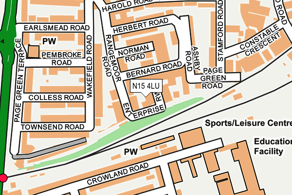
N15 4LU is located in the South Tottenham electoral ward, within the London borough of Haringey and the English Parliamentary constituency of Tottenham. The Sub Integrated Care Board (ICB) Location is NHS North Central London ICB - 93C and the police force is Metropolitan Police. This postcode has been in use since December 1994.


GetTheData
Source: OS OpenMap – Local (Ordnance Survey)
Source: OS VectorMap District (Ordnance Survey)
Licence: Open Government Licence (requires attribution)
| Easting | 533940 |
| Northing | 188756 |
| Latitude | 51.581756 |
| Longitude | -0.068291 |
GetTheData
Source: Open Postcode Geo
Licence: Open Government Licence
| Country | England |
| Postcode District | N15 |
➜ See where N15 is on a map | |
GetTheData
Source: Land Registry Price Paid Data
Licence: Open Government Licence
Elevation or altitude of N15 4LU as distance above sea level:
| Metres | Feet | |
|---|---|---|
| Elevation | 10m | 33ft |
Elevation is measured from the approximate centre of the postcode, to the nearest point on an OS contour line from OS Terrain 50, which has contour spacing of ten vertical metres.
➜ How high above sea level am I? Find the elevation of your current position using your device's GPS.
GetTheData
Source: Open Postcode Elevation
Licence: Open Government Licence
| Ward | South Tottenham |
| Constituency | Tottenham |
GetTheData
Source: ONS Postcode Database
Licence: Open Government Licence
| South Tottenham Station | South Tottenham | 292m |
| Wakefield Road (Broad Lane) | South Tottenham | 295m |
| Seven Sisters Road (High Road) | South Tottenham | 295m |
| Seven Sisters Road (High Road) | South Tottenham | 307m |
| South Tottenham Station (High Road) | South Tottenham | 323m |
| Seven Sisters Underground Station | Seven Sisters | 345m |
| Tottenham Hale Underground Station | Tottenham Hale | 900m |
| South Tottenham Station | 0.3km |
| Seven Sisters Station | 0.5km |
| Tottenham Hale Station | 0.9km |
GetTheData
Source: NaPTAN
Licence: Open Government Licence
| Median download speed | 80.0Mbps |
| Average download speed | 58.6Mbps |
| Maximum download speed | 80.00Mbps |
| Median upload speed | 20.0Mbps |
| Average upload speed | 14.6Mbps |
| Maximum upload speed | 20.00Mbps |
GetTheData
Source: Ofcom
Licence: Ofcom Terms of Use (requires attribution)
GetTheData
Source: ONS Postcode Database
Licence: Open Government Licence


➜ Get more ratings from the Food Standards Agency
GetTheData
Source: Food Standards Agency
Licence: FSA terms & conditions
| Last Collection | |||
|---|---|---|---|
| Location | Mon-Fri | Sat | Distance |
| 22 Wakefield Road | 17:30 | 12:00 | 113m |
| 87 Broad Lane | 18:30 | 12:00 | 308m |
| 123 Gladesmore Road/ | 17:30 | 12:00 | 313m |
GetTheData
Source: Dracos
Licence: Creative Commons Attribution-ShareAlike
The below table lists the International Territorial Level (ITL) codes (formerly Nomenclature of Territorial Units for Statistics (NUTS) codes) and Local Administrative Units (LAU) codes for N15 4LU:
| ITL 1 Code | Name |
|---|---|
| TLI | London |
| ITL 2 Code | Name |
| TLI4 | Inner London - East |
| ITL 3 Code | Name |
| TLI43 | Haringey and Islington |
| LAU 1 Code | Name |
| E09000014 | Haringey |
GetTheData
Source: ONS Postcode Directory
Licence: Open Government Licence
The below table lists the Census Output Area (OA), Lower Layer Super Output Area (LSOA), and Middle Layer Super Output Area (MSOA) for N15 4LU:
| Code | Name | |
|---|---|---|
| OA | E00010394 | |
| LSOA | E01002072 | Haringey 025D |
| MSOA | E02000421 | Haringey 025 |
GetTheData
Source: ONS Postcode Directory
Licence: Open Government Licence
| N15 4ND | Norman Road | 88m |
| N15 4NL | Wakefield Road | 104m |
| N15 6UR | Crowland Road | 117m |
| N15 4NN | Wakefield Road | 132m |
| N15 4PG | Page Green Road | 140m |
| N15 4PF | Ashby Road | 145m |
| N15 6UZ | Elm Park Avenue | 164m |
| N15 4PH | Stamford Road | 168m |
| N15 4PE | Herbert Road | 169m |
| N15 6UU | Crowland Road | 177m |
GetTheData
Source: Open Postcode Geo; Land Registry Price Paid Data
Licence: Open Government Licence