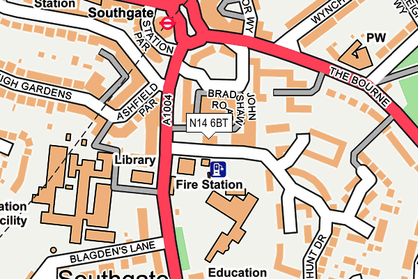
N14 6BT is located in the Southgate electoral ward, within the London borough of Enfield and the English Parliamentary constituency of Enfield, Southgate. The Sub Integrated Care Board (ICB) Location is NHS North Central London ICB - 93C and the police force is Metropolitan Police. This postcode has been in use since August 1993.


GetTheData
Source: OS OpenMap – Local (Ordnance Survey)
Source: OS VectorMap District (Ordnance Survey)
Licence: Open Government Licence (requires attribution)
| Easting | 529765 |
| Northing | 194133 |
| Latitude | 51.631055 |
| Longitude | -0.126498 |
GetTheData
Source: Open Postcode Geo
Licence: Open Government Licence
| Country | England |
| Postcode District | N14 |
➜ See where N14 is on a map ➜ Where is Southgate? | |
GetTheData
Source: Land Registry Price Paid Data
Licence: Open Government Licence
Elevation or altitude of N14 6BT as distance above sea level:
| Metres | Feet | |
|---|---|---|
| Elevation | 70m | 230ft |
Elevation is measured from the approximate centre of the postcode, to the nearest point on an OS contour line from OS Terrain 50, which has contour spacing of ten vertical metres.
➜ How high above sea level am I? Find the elevation of your current position using your device's GPS.
GetTheData
Source: Open Postcode Elevation
Licence: Open Government Licence
| Ward | Southgate |
| Constituency | Enfield, Southgate |
GetTheData
Source: ONS Postcode Database
Licence: Open Government Licence
| Southgate College | Southgate | 111m |
| The Bournebournside Crescent | Southgate | 113m |
| Southgate (Station Parade) | Southgate | 136m |
| Southgate | Southgate | 151m |
| Southgate (Station Parade) | Southgate | 156m |
| Southgate Underground Station | Southgate | 166m |
| Palmers Green Station | 1.8km |
| Winchmore Hill Station | 1.8km |
| New Southgate Station | 2.2km |
GetTheData
Source: NaPTAN
Licence: Open Government Licence
GetTheData
Source: ONS Postcode Database
Licence: Open Government Licence


➜ Get more ratings from the Food Standards Agency
GetTheData
Source: Food Standards Agency
Licence: FSA terms & conditions
| Last Collection | |||
|---|---|---|---|
| Location | Mon-Fri | Sat | Distance |
| Southgate Delivery Office | 18:30 | 12:00 | 117m |
| Dennis Parade | 17:30 | 12:00 | 216m |
| The Bourne/Queen Elizabeths Dr | 17:30 | 12:00 | 241m |
GetTheData
Source: Dracos
Licence: Creative Commons Attribution-ShareAlike
The below table lists the International Territorial Level (ITL) codes (formerly Nomenclature of Territorial Units for Statistics (NUTS) codes) and Local Administrative Units (LAU) codes for N14 6BT:
| ITL 1 Code | Name |
|---|---|
| TLI | London |
| ITL 2 Code | Name |
| TLI5 | Outer London - East and North East |
| ITL 3 Code | Name |
| TLI54 | Enfield |
| LAU 1 Code | Name |
| E09000010 | Enfield |
GetTheData
Source: ONS Postcode Directory
Licence: Open Government Licence
The below table lists the Census Output Area (OA), Lower Layer Super Output Area (LSOA), and Middle Layer Super Output Area (MSOA) for N14 6BT:
| Code | Name | |
|---|---|---|
| OA | E00007576 | |
| LSOA | E01001519 | Enfield 020D |
| MSOA | E02000296 | Enfield 020 |
GetTheData
Source: ONS Postcode Directory
Licence: Open Government Licence
| N14 6QN | Grange Gardens | 69m |
| N14 6QP | Grange Gardens | 98m |
| N14 6SP | Bourneside Crescent | 105m |
| N14 6QW | Grange Gardens | 110m |
| N14 6BZ | Leigh Hunt Drive | 115m |
| N14 6BP | High Street | 116m |
| N14 5EH | Ashfield Parade | 132m |
| N14 6PH | The Broadway | 142m |
| N14 6PS | Tudor Way | 142m |
| N14 6DA | Leigh Hunt Drive | 143m |
GetTheData
Source: Open Postcode Geo; Land Registry Price Paid Data
Licence: Open Government Licence