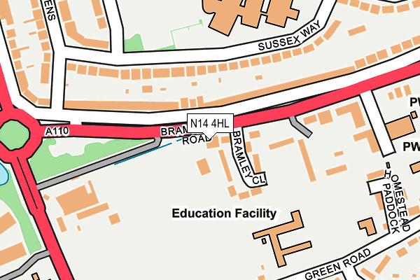
N14 4HL is located in the Cockfosters electoral ward, within the London borough of Enfield and the English Parliamentary constituency of Enfield, Southgate. The Sub Integrated Care Board (ICB) Location is NHS North Central London ICB - 93C and the police force is Metropolitan Police. This postcode has been in use since January 1980.


GetTheData
Source: OS OpenMap – Local (Ordnance Survey)
Source: OS VectorMap District (Ordnance Survey)
Licence: Open Government Licence (requires attribution)
| Easting | 528617 |
| Northing | 195635 |
| Latitude | 51.644816 |
| Longitude | -0.142524 |
GetTheData
Source: Open Postcode Geo
Licence: Open Government Licence
| Country | England |
| Postcode District | N14 |
➜ See where N14 is on a map ➜ Where is London? | |
GetTheData
Source: Land Registry Price Paid Data
Licence: Open Government Licence
Elevation or altitude of N14 4HL as distance above sea level:
| Metres | Feet | |
|---|---|---|
| Elevation | 90m | 295ft |
Elevation is measured from the approximate centre of the postcode, to the nearest point on an OS contour line from OS Terrain 50, which has contour spacing of ten vertical metres.
➜ How high above sea level am I? Find the elevation of your current position using your device's GPS.
GetTheData
Source: Open Postcode Elevation
Licence: Open Government Licence
| Ward | Cockfosters |
| Constituency | Enfield, Southgate |
GetTheData
Source: ONS Postcode Database
Licence: Open Government Licence
| Cockfosters Road (Bramley Road) | Oakwood | 169m |
| Cockfosters Road | Oakwood | 169m |
| Peace Close | Oakwood | 213m |
| Bramley Road (N14) | Oakwood | 235m |
| Bramley Road (N14) | Oakwood | 257m |
| Oakwood Underground Station | Oakwood | 788m |
| Cockfosters Underground Station | Cockfosters | 875m |
| Southgate Underground Station | Southgate | 1,724m |
| Oakleigh Park Station | 1.8km |
| New Barnet Station | 2.1km |
| Winchmore Hill Station | 3.1km |
GetTheData
Source: NaPTAN
Licence: Open Government Licence
GetTheData
Source: ONS Postcode Database
Licence: Open Government Licence


➜ Get more ratings from the Food Standards Agency
GetTheData
Source: Food Standards Agency
Licence: FSA terms & conditions
| Last Collection | |||
|---|---|---|---|
| Location | Mon-Fri | Sat | Distance |
| 60 Bramley Road | 17:30 | 12:00 | 88m |
| Sussex Way | 18:30 | 12:00 | 379m |
| Chase Side/Green Road | 17:30 | 12:00 | 420m |
GetTheData
Source: Dracos
Licence: Creative Commons Attribution-ShareAlike
The below table lists the International Territorial Level (ITL) codes (formerly Nomenclature of Territorial Units for Statistics (NUTS) codes) and Local Administrative Units (LAU) codes for N14 4HL:
| ITL 1 Code | Name |
|---|---|
| TLI | London |
| ITL 2 Code | Name |
| TLI5 | Outer London - East and North East |
| ITL 3 Code | Name |
| TLI54 | Enfield |
| LAU 1 Code | Name |
| E09000010 | Enfield |
GetTheData
Source: ONS Postcode Directory
Licence: Open Government Licence
The below table lists the Census Output Area (OA), Lower Layer Super Output Area (LSOA), and Middle Layer Super Output Area (MSOA) for N14 4HL:
| Code | Name | |
|---|---|---|
| OA | E00007073 | |
| LSOA | E01001420 | Enfield 020B |
| MSOA | E02000296 | Enfield 020 |
GetTheData
Source: ONS Postcode Directory
Licence: Open Government Licence
| N14 4HJ | Bramley Close | 77m |
| EN4 0BH | Sussex Way | 137m |
| N14 4HR | Bramley Road | 138m |
| N14 4HH | The Poplars | 150m |
| N14 4HS | Bramley Road | 151m |
| N14 4HG | Bramley Road | 163m |
| EN4 0BG | Sussex Way | 203m |
| N14 4AN | Homestead Paddock | 255m |
| N14 4HP | Bramley Road | 260m |
| N14 4HD | Bramley Road | 287m |
GetTheData
Source: Open Postcode Geo; Land Registry Price Paid Data
Licence: Open Government Licence