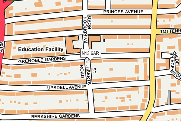
N13 6AR lies on St Cuthberts Road in London. N13 6AR is located in the Bowes electoral ward, within the London borough of Enfield and the English Parliamentary constituency of Enfield, Southgate. The Sub Integrated Care Board (ICB) Location is NHS North Central London ICB - 93C and the police force is Metropolitan Police. This postcode has been in use since September 2004.


GetTheData
Source: OS OpenMap – Local (Ordnance Survey)
Source: OS VectorMap District (Ordnance Survey)
Licence: Open Government Licence (requires attribution)
| Easting | 531285 |
| Northing | 191868 |
| Latitude | 51.610348 |
| Longitude | -0.105399 |
GetTheData
Source: Open Postcode Geo
Licence: Open Government Licence
| Street | St Cuthberts Road |
| Town/City | London |
| Country | England |
| Postcode District | N13 |
➜ See where N13 is on a map ➜ Where is London? | |
GetTheData
Source: Land Registry Price Paid Data
Licence: Open Government Licence
Elevation or altitude of N13 6AR as distance above sea level:
| Metres | Feet | |
|---|---|---|
| Elevation | 30m | 98ft |
Elevation is measured from the approximate centre of the postcode, to the nearest point on an OS contour line from OS Terrain 50, which has contour spacing of ten vertical metres.
➜ How high above sea level am I? Find the elevation of your current position using your device's GPS.
GetTheData
Source: Open Postcode Elevation
Licence: Open Government Licence
| Ward | Bowes |
| Constituency | Enfield, Southgate |
GetTheData
Source: ONS Postcode Database
Licence: Open Government Licence
| Green Lanes North Circular Rd | Palmers Green | 268m |
| Tottenhall Rd Nth Circular Rd (Green Lanes) | Palmers Green | 297m |
| Tottenhall Rd Nth Circular Rd (Green Lanes) | Palmers Green | 309m |
| Green Lanes North Circular Rd | Palmers Green | 327m |
| Berkshire Gardens (Green Lanes) | Palmers Green | 356m |
| Bounds Green Underground Station | Wood Green | 1,354m |
| Wood Green Underground Station | Wood Green | 1,464m |
| Palmers Green Station | 1km |
| Bowes Park Station | 1.1km |
| Alexandra Palace Station | 1.7km |
GetTheData
Source: NaPTAN
Licence: Open Government Licence
| Percentage of properties with Next Generation Access | 100.0% |
| Percentage of properties with Superfast Broadband | 100.0% |
| Percentage of properties with Ultrafast Broadband | 0.0% |
| Percentage of properties with Full Fibre Broadband | 0.0% |
Superfast Broadband is between 30Mbps and 300Mbps
Ultrafast Broadband is > 300Mbps
| Percentage of properties unable to receive 2Mbps | 0.0% |
| Percentage of properties unable to receive 5Mbps | 0.0% |
| Percentage of properties unable to receive 10Mbps | 0.0% |
| Percentage of properties unable to receive 30Mbps | 0.0% |
GetTheData
Source: Ofcom
Licence: Ofcom Terms of Use (requires attribution)
GetTheData
Source: ONS Postcode Database
Licence: Open Government Licence


➜ Get more ratings from the Food Standards Agency
GetTheData
Source: Food Standards Agency
Licence: FSA terms & conditions
| Last Collection | |||
|---|---|---|---|
| Location | Mon-Fri | Sat | Distance |
| 78 Upsdell Avenue | 17:30 | 12:00 | 82m |
| 114 Tottenhall Road | 17:30 | 12:00 | 285m |
| Berkshire Gardens/Wolves Lane | 17:30 | 12:00 | 308m |
GetTheData
Source: Dracos
Licence: Creative Commons Attribution-ShareAlike
The below table lists the International Territorial Level (ITL) codes (formerly Nomenclature of Territorial Units for Statistics (NUTS) codes) and Local Administrative Units (LAU) codes for N13 6AR:
| ITL 1 Code | Name |
|---|---|
| TLI | London |
| ITL 2 Code | Name |
| TLI5 | Outer London - East and North East |
| ITL 3 Code | Name |
| TLI54 | Enfield |
| LAU 1 Code | Name |
| E09000010 | Enfield |
GetTheData
Source: ONS Postcode Directory
Licence: Open Government Licence
The below table lists the Census Output Area (OA), Lower Layer Super Output Area (LSOA), and Middle Layer Super Output Area (MSOA) for N13 6AR:
| Code | Name | |
|---|---|---|
| OA | E00006944 | |
| LSOA | E01001394 | Enfield 035A |
| MSOA | E02000311 | Enfield 035 |
GetTheData
Source: ONS Postcode Directory
Licence: Open Government Licence
| N13 6JH | Grenoble Gardens | 75m |
| N13 6JJ | Upsdell Avenue | 97m |
| N13 6JL | Upsdell Avenue | 125m |
| N13 6JD | Grenoble Gardens | 142m |
| N13 6JB | Tottenhall Road | 145m |
| N13 6JE | Grenoble Gardens | 146m |
| N13 6JG | Grenoble Gardens | 150m |
| N13 6JA | Tottenhall Road | 150m |
| N13 6JP | Upsdell Avenue | 167m |
| N13 6HY | Tottenhall Road | 171m |
GetTheData
Source: Open Postcode Geo; Land Registry Price Paid Data
Licence: Open Government Licence