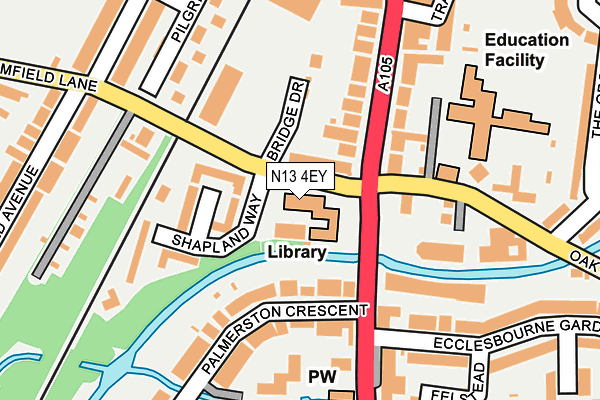
N13 4EY is located in the Palmers Green electoral ward, within the London borough of Enfield and the English Parliamentary constituency of Enfield, Southgate. The Sub Integrated Care Board (ICB) Location is NHS North Central London ICB - 93C and the police force is Metropolitan Police. This postcode has been in use since January 1980.


GetTheData
Source: OS OpenMap – Local (Ordnance Survey)
Source: OS VectorMap District (Ordnance Survey)
Licence: Open Government Licence (requires attribution)
| Easting | 530910 |
| Northing | 192441 |
| Latitude | 51.615582 |
| Longitude | -0.110622 |
GetTheData
Source: Open Postcode Geo
Licence: Open Government Licence
| Country | England |
| Postcode District | N13 |
➜ See where N13 is on a map ➜ Where is London? | |
GetTheData
Source: Land Registry Price Paid Data
Licence: Open Government Licence
Elevation or altitude of N13 4EY as distance above sea level:
| Metres | Feet | |
|---|---|---|
| Elevation | 30m | 98ft |
Elevation is measured from the approximate centre of the postcode, to the nearest point on an OS contour line from OS Terrain 50, which has contour spacing of ten vertical metres.
➜ How high above sea level am I? Find the elevation of your current position using your device's GPS.
GetTheData
Source: Open Postcode Elevation
Licence: Open Government Licence
| Ward | Palmers Green |
| Constituency | Enfield, Southgate |
GetTheData
Source: ONS Postcode Database
Licence: Open Government Licence
| Broomfield Lane (Green Lanes) | Palmers Green | 87m |
| Broomfield Lane (Green Lanes) | Palmers Green | 88m |
| Palmers Green The Triangle (Green Lanes) | Palmers Green | 186m |
| Palmers Green The Triangle (Green Lanes) | Palmers Green | 211m |
| North Circular Rd Green Lanes | Palmers Green | 260m |
| Bounds Green Underground Station | Wood Green | 1,339m |
| Palmers Green Station | 0.3km |
| Bowes Park Station | 1.2km |
| Alexandra Palace Station | 2.1km |
GetTheData
Source: NaPTAN
Licence: Open Government Licence
GetTheData
Source: ONS Postcode Database
Licence: Open Government Licence


➜ Get more ratings from the Food Standards Agency
GetTheData
Source: Food Standards Agency
Licence: FSA terms & conditions
| Last Collection | |||
|---|---|---|---|
| Location | Mon-Fri | Sat | Distance |
| 263 | 17:30 | 12:00 | 98m |
| Firscroft/The Larches | 17:30 | 12:00 | 226m |
| 59 Palmerston Crescent | 17:30 | 12:00 | 236m |
GetTheData
Source: Dracos
Licence: Creative Commons Attribution-ShareAlike
The below table lists the International Territorial Level (ITL) codes (formerly Nomenclature of Territorial Units for Statistics (NUTS) codes) and Local Administrative Units (LAU) codes for N13 4EY:
| ITL 1 Code | Name |
|---|---|
| TLI | London |
| ITL 2 Code | Name |
| TLI5 | Outer London - East and North East |
| ITL 3 Code | Name |
| TLI54 | Enfield |
| LAU 1 Code | Name |
| E09000010 | Enfield |
GetTheData
Source: ONS Postcode Directory
Licence: Open Government Licence
The below table lists the Census Output Area (OA), Lower Layer Super Output Area (LSOA), and Middle Layer Super Output Area (MSOA) for N13 4EY:
| Code | Name | |
|---|---|---|
| OA | E00007442 | |
| LSOA | E01001501 | Enfield 036E |
| MSOA | E02000312 | Enfield 036 |
GetTheData
Source: ONS Postcode Directory
Licence: Open Government Licence
| N13 4DQ | Green Lanes | 39m |
| N13 5UJ | Green Lanes | 105m |
| N13 4EZ | Shapland Way | 107m |
| N13 4UA | Palmerston Crescent | 114m |
| N13 5UE | Green Lanes | 134m |
| N13 4UE | Palmerston Crescent | 135m |
| N13 4XE | Green Lanes | 135m |
| N13 4UG | Palmerston Crescent | 139m |
| N13 4EX | Davey Close | 172m |
| N13 4HX | Pilgrims Close | 173m |
GetTheData
Source: Open Postcode Geo; Land Registry Price Paid Data
Licence: Open Government Licence