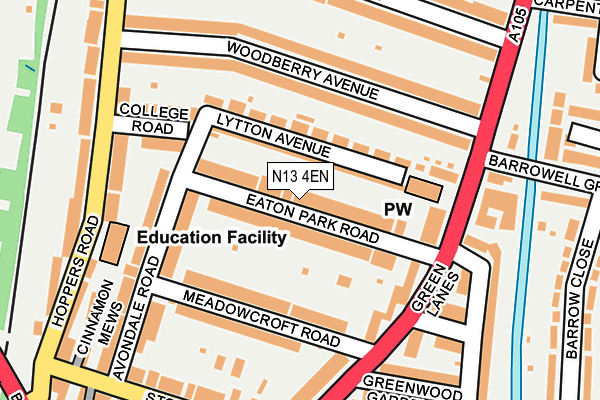
N13 4EN is located in the Arnos Grove electoral ward, within the London borough of Enfield and the English Parliamentary constituency of Enfield, Southgate. The Sub Integrated Care Board (ICB) Location is NHS North Central London ICB - 93C and the police force is Metropolitan Police. This postcode has been in use since July 2017.


GetTheData
Source: OS OpenMap – Local (Ordnance Survey)
Source: OS VectorMap District (Ordnance Survey)
Licence: Open Government Licence (requires attribution)
| Easting | 530285 |
| Northing | 192119 |
| Latitude | 51.612836 |
| Longitude | -0.119738 |
GetTheData
Source: Open Postcode Geo
Licence: Open Government Licence
| Country | England |
| Postcode District | N13 |
➜ See where N13 is on a map ➜ Where is London? | |
GetTheData
Source: Land Registry Price Paid Data
Licence: Open Government Licence
| Ward | Arnos Grove |
| Constituency | Enfield, Southgate |
GetTheData
Source: ONS Postcode Database
Licence: Open Government Licence
| Westminster Drive | Palmers Green | 114m |
| Pymmes Road | Palmers Green | 138m |
| Westminster Drive (Powys Lane) | Palmers Green | 142m |
| Bowes Road | Palmers Green | 159m |
| Bowes Road | Palmers Green | 163m |
| Bounds Green Underground Station | Wood Green | 716m |
| Arnos Grove Underground Station | Arnos Grove | 1,005m |
| Bowes Park Station | 0.7km |
| Palmers Green Station | 0.9km |
| New Southgate Station | 1.6km |
GetTheData
Source: NaPTAN
Licence: Open Government Licence
| Percentage of properties with Next Generation Access | 100.0% |
| Percentage of properties with Superfast Broadband | 100.0% |
| Percentage of properties with Ultrafast Broadband | 0.0% |
| Percentage of properties with Full Fibre Broadband | 0.0% |
Superfast Broadband is between 30Mbps and 300Mbps
Ultrafast Broadband is > 300Mbps
| Median download speed | 53.6Mbps |
| Average download speed | 47.2Mbps |
| Maximum download speed | 73.04Mbps |
| Median upload speed | 11.5Mbps |
| Average upload speed | 11.7Mbps |
| Maximum upload speed | 19.53Mbps |
| Percentage of properties unable to receive 2Mbps | 0.0% |
| Percentage of properties unable to receive 5Mbps | 0.0% |
| Percentage of properties unable to receive 10Mbps | 0.0% |
| Percentage of properties unable to receive 30Mbps | 0.0% |
GetTheData
Source: Ofcom
Licence: Ofcom Terms of Use (requires attribution)
GetTheData
Source: ONS Postcode Database
Licence: Open Government Licence


➜ Get more ratings from the Food Standards Agency
GetTheData
Source: Food Standards Agency
Licence: FSA terms & conditions
| Last Collection | |||
|---|---|---|---|
| Location | Mon-Fri | Sat | Distance |
| Brownlow Road/Elvendon Road | 17:30 | 12:00 | 261m |
| Hawthorne Avenue/Powys Lane | 17:30 | 12:00 | 312m |
| Highworth Road/Bowes Road | 17:30 | 12:00 | 404m |
GetTheData
Source: Dracos
Licence: Creative Commons Attribution-ShareAlike
The below table lists the International Territorial Level (ITL) codes (formerly Nomenclature of Territorial Units for Statistics (NUTS) codes) and Local Administrative Units (LAU) codes for N13 4EN:
| ITL 1 Code | Name |
|---|---|
| TLI | London |
| ITL 2 Code | Name |
| TLI5 | Outer London - East and North East |
| ITL 3 Code | Name |
| TLI54 | Enfield |
| LAU 1 Code | Name |
| E09000010 | Enfield |
GetTheData
Source: ONS Postcode Directory
Licence: Open Government Licence
The below table lists the Census Output Area (OA), Lower Layer Super Output Area (LSOA), and Middle Layer Super Output Area (MSOA) for N13 4EN:
| Code | Name | |
|---|---|---|
| OA | E00007592 | |
| LSOA | E01001527 | Enfield 036F |
| MSOA | E02000312 | Enfield 036 |
GetTheData
Source: ONS Postcode Directory
Licence: Open Government Licence
| N13 4NP | Bowes Road | 39m |
| N13 4SB | Bowes Road | 53m |
| N13 4SE | Bowes Road | 92m |
| N13 4NS | Powys Lane | 108m |
| N13 4NU | Westminster Drive | 123m |
| N11 2JE | Bowes Road | 136m |
| N13 4SD | Livingstone Road | 147m |
| N11 2JA | Bowes Road | 149m |
| N13 4SL | Hardwicke Road | 152m |
| N13 4NX | Powys Lane | 154m |
GetTheData
Source: Open Postcode Geo; Land Registry Price Paid Data
Licence: Open Government Licence