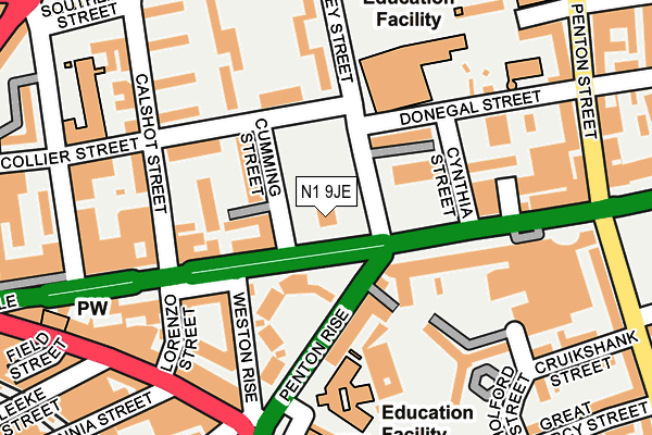
N1 9JE is located in the Caledonian electoral ward, within the London borough of Islington and the English Parliamentary constituency of Islington South and Finsbury. The Sub Integrated Care Board (ICB) Location is NHS North Central London ICB - 93C and the police force is Metropolitan Police. This postcode has been in use since February 2017.


GetTheData
Source: OS OpenMap – Local (Ordnance Survey)
Source: OS VectorMap District (Ordnance Survey)
Licence: Open Government Licence (requires attribution)
| Easting | 530856 |
| Northing | 183095 |
| Latitude | 51.531609 |
| Longitude | -0.114854 |
GetTheData
Source: Open Postcode Geo
Licence: Open Government Licence
| Country | England |
| Postcode District | N1 |
➜ See where N1 is on a map ➜ Where is London? | |
GetTheData
Source: Land Registry Price Paid Data
Licence: Open Government Licence
| Ward | Caledonian |
| Constituency | Islington South And Finsbury |
GetTheData
Source: ONS Postcode Database
Licence: Open Government Licence
| Penton Rise (Pentonville Road) | Pentonville | 54m |
| Penton Rise (Pentonville Road) | Pentonville | 70m |
| Penton Rise | Pentonville | 109m |
| Penton Street (Pentonville Road) | Pentonville | 217m |
| Kings Cross Road | Pentonville | 261m |
| King's Cross St. Pancras Underground Station | King's Cross | 586m |
| Angel Underground Station | Angel | 633m |
| Russell Square Underground Station | Russell Square | 1,152m |
| Euston Underground Station | Euston | 1,372m |
| Farringdon Underground Station | Farringdon | 1,440m |
| London Kings Cross Station | 0.6km |
| London St Pancras International Station | 0.9km |
| London St Pancras International LL Station | 0.9km |
GetTheData
Source: NaPTAN
Licence: Open Government Licence
GetTheData
Source: ONS Postcode Database
Licence: Open Government Licence


➜ Get more ratings from the Food Standards Agency
GetTheData
Source: Food Standards Agency
Licence: FSA terms & conditions
| Last Collection | |||
|---|---|---|---|
| Location | Mon-Fri | Sat | Distance |
| 192 Pentonville Road | 18:30 | 12:00 | 188m |
| Kings Cross Road (Britannia St) | 18:30 | 12:00 | 210m |
| 100 Caledonian Road | 18:30 | 12:00 | 339m |
GetTheData
Source: Dracos
Licence: Creative Commons Attribution-ShareAlike
The below table lists the International Territorial Level (ITL) codes (formerly Nomenclature of Territorial Units for Statistics (NUTS) codes) and Local Administrative Units (LAU) codes for N1 9JE:
| ITL 1 Code | Name |
|---|---|
| TLI | London |
| ITL 2 Code | Name |
| TLI4 | Inner London - East |
| ITL 3 Code | Name |
| TLI43 | Haringey and Islington |
| LAU 1 Code | Name |
| E09000019 | Islington |
GetTheData
Source: ONS Postcode Directory
Licence: Open Government Licence
The below table lists the Census Output Area (OA), Lower Layer Super Output Area (LSOA), and Middle Layer Super Output Area (MSOA) for N1 9JE:
| Code | Name | |
|---|---|---|
| OA | E00174843 | |
| LSOA | E01002697 | Islington 019B |
| MSOA | E02000572 | Islington 019 |
GetTheData
Source: ONS Postcode Directory
Licence: Open Government Licence
| N1 9JL | Pentonville Road | 61m |
| WC1X 9EF | Penton Rise | 68m |
| WC1X 9EG | Penton Rise | 71m |
| N1 9HW | Cumming Street | 77m |
| N1 9JH | Rodney Street | 83m |
| N1 9JA | Cumming Street | 87m |
| WC1X 9ED | Penton Rise | 95m |
| N1 9QF | Donegal Street | 103m |
| N1 9JW | Calshot Street | 111m |
| WC1X 9EB | Penton Rise | 123m |
GetTheData
Source: Open Postcode Geo; Land Registry Price Paid Data
Licence: Open Government Licence