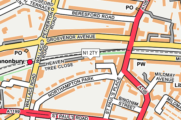
N1 2TY is located in the Mildmay electoral ward, within the London borough of Islington and the English Parliamentary constituency of Islington North. The Sub Integrated Care Board (ICB) Location is NHS North Central London ICB - 93C and the police force is Metropolitan Police. This postcode has been in use since April 2004.


GetTheData
Source: OS OpenMap – Local (Ordnance Survey)
Source: OS VectorMap District (Ordnance Survey)
Licence: Open Government Licence (requires attribution)
| Easting | 532586 |
| Northing | 185039 |
| Latitude | 51.548673 |
| Longitude | -0.089222 |
GetTheData
Source: Open Postcode Geo
Licence: Open Government Licence
| Country | England |
| Postcode District | N1 |
➜ See where N1 is on a map ➜ Where is London? | |
GetTheData
Source: Land Registry Price Paid Data
Licence: Open Government Licence
Elevation or altitude of N1 2TY as distance above sea level:
| Metres | Feet | |
|---|---|---|
| Elevation | 20m | 66ft |
Elevation is measured from the approximate centre of the postcode, to the nearest point on an OS contour line from OS Terrain 50, which has contour spacing of ten vertical metres.
➜ How high above sea level am I? Find the elevation of your current position using your device's GPS.
GetTheData
Source: Open Postcode Elevation
Licence: Open Government Licence
| Ward | Mildmay |
| Constituency | Islington North |
GetTheData
Source: ONS Postcode Database
Licence: Open Government Licence
| Beresford Road (N5) (Beresford Road) | Canonbury | 156m |
| Beresford Road (N5) | Canonbury | 180m |
| Beresford Road (N5) (Beresford Road) | Canonbury | 181m |
| Clephane Road | Canonbury | 197m |
| Beresford Road (N5) | Canonbury | 204m |
| Highbury & Islington Underground Station | Highbury & Islington | 1,012m |
| Arsenal Underground Station | Arsenal | 1,683m |
| Canonbury Station | 0.2km |
| Dalston Kingsland Station | 0.9km |
| Essex Road Station | 1km |
GetTheData
Source: NaPTAN
Licence: Open Government Licence
Estimated total energy consumption in N1 2TY by fuel type, 2015.
| Consumption (kWh) | 25,526 |
|---|---|
| Meter count | 12 |
| Mean (kWh/meter) | 2,127 |
| Median (kWh/meter) | 2,058 |
GetTheData
Source: Postcode level gas estimates: 2015 (experimental)
Source: Postcode level electricity estimates: 2015 (experimental)
Licence: Open Government Licence
GetTheData
Source: ONS Postcode Database
Licence: Open Government Licence


➜ Get more ratings from the Food Standards Agency
GetTheData
Source: Food Standards Agency
Licence: FSA terms & conditions
| Last Collection | |||
|---|---|---|---|
| Location | Mon-Fri | Sat | Distance |
| Northampton Park | 18:30 | 12:00 | 53m |
| 91 Grosvenor Avenue | 17:30 | 12:00 | 212m |
| 113 Newington Green Road | 18:30 | 12:00 | 248m |
GetTheData
Source: Dracos
Licence: Creative Commons Attribution-ShareAlike
The below table lists the International Territorial Level (ITL) codes (formerly Nomenclature of Territorial Units for Statistics (NUTS) codes) and Local Administrative Units (LAU) codes for N1 2TY:
| ITL 1 Code | Name |
|---|---|
| TLI | London |
| ITL 2 Code | Name |
| TLI4 | Inner London - East |
| ITL 3 Code | Name |
| TLI43 | Haringey and Islington |
| LAU 1 Code | Name |
| E09000019 | Islington |
GetTheData
Source: ONS Postcode Directory
Licence: Open Government Licence
The below table lists the Census Output Area (OA), Lower Layer Super Output Area (LSOA), and Middle Layer Super Output Area (MSOA) for N1 2TY:
| Code | Name | |
|---|---|---|
| OA | E00013864 | |
| LSOA | E01002780 | Islington 014F |
| MSOA | E02000567 | Islington 014 |
GetTheData
Source: ONS Postcode Directory
Licence: Open Government Licence
| N1 2FS | Northampton Grove | 58m |
| N1 2PL | Northampton Grove | 67m |
| N5 2NP | Grosvenor Avenue | 72m |
| N1 2PW | Heaven Tree Close | 82m |
| N5 2NR | Grosvenor Avenue | 98m |
| N1 2PJ | Northampton Park | 102m |
| N1 4QU | Newington Green Road | 108m |
| N1 2QE | St Pauls Place | 112m |
| N5 2NN | Grosvenor Avenue | 119m |
| N1 2PP | Northampton Park | 130m |
GetTheData
Source: Open Postcode Geo; Land Registry Price Paid Data
Licence: Open Government Licence