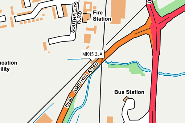
MK45 3JA is located in the Wixams & Wilstead electoral ward, within the unitary authority of Bedford and the English Parliamentary constituency of Mid Bedfordshire. The Sub Integrated Care Board (ICB) Location is NHS Bedfordshire, Luton and Milton Keynes ICB - M1J4Y and the police force is Bedfordshire. This postcode has been in use since January 1980.


GetTheData
Source: OS OpenMap – Local (Ordnance Survey)
Source: OS VectorMap District (Ordnance Survey)
Licence: Open Government Licence (requires attribution)
| Easting | 504183 |
| Northing | 247195 |
| Latitude | 52.113274 |
| Longitude | -0.479988 |
GetTheData
Source: Open Postcode Geo
Licence: Open Government Licence
| Country | England |
| Postcode District | MK45 |
➜ See where MK45 is on a map | |
GetTheData
Source: Land Registry Price Paid Data
Licence: Open Government Licence
Elevation or altitude of MK45 3JA as distance above sea level:
| Metres | Feet | |
|---|---|---|
| Elevation | 30m | 98ft |
Elevation is measured from the approximate centre of the postcode, to the nearest point on an OS contour line from OS Terrain 50, which has contour spacing of ten vertical metres.
➜ How high above sea level am I? Find the elevation of your current position using your device's GPS.
GetTheData
Source: Open Postcode Elevation
Licence: Open Government Licence
| Ward | Wixams & Wilstead |
| Constituency | Mid Bedfordshire |
GetTheData
Source: ONS Postcode Database
Licence: Open Government Licence
| Elstow Park And Ride (Progress Park) | Elstow | 166m |
| The Fire Station (Elstow Road) | Kempston | 321m |
| The Mullberry Bush (Orchard Street) | Kempston | 427m |
| The Mullberry Bush (Orchard Street) | Kempston | 451m |
| Interchange Park (Polofield Way) | Kempston | 455m |
| Bedford St Johns Station | 2km |
| Bedford Station | 2.5km |
| Kempston Hardwick Station | 2.9km |
GetTheData
Source: NaPTAN
Licence: Open Government Licence
| Percentage of properties with Next Generation Access | 100.0% |
| Percentage of properties with Superfast Broadband | 100.0% |
| Percentage of properties with Ultrafast Broadband | 0.0% |
| Percentage of properties with Full Fibre Broadband | 0.0% |
Superfast Broadband is between 30Mbps and 300Mbps
Ultrafast Broadband is > 300Mbps
| Percentage of properties unable to receive 2Mbps | 0.0% |
| Percentage of properties unable to receive 5Mbps | 0.0% |
| Percentage of properties unable to receive 10Mbps | 0.0% |
| Percentage of properties unable to receive 30Mbps | 0.0% |
GetTheData
Source: Ofcom
Licence: Ofcom Terms of Use (requires attribution)
GetTheData
Source: ONS Postcode Database
Licence: Open Government Licence


➜ Get more ratings from the Food Standards Agency
GetTheData
Source: Food Standards Agency
Licence: FSA terms & conditions
| Last Collection | |||
|---|---|---|---|
| Location | Mon-Fri | Sat | Distance |
| Post Office Springfield Centre | 18:35 | 12:10 | 448m |
| Cosmic Avenue | 18:20 | 12:15 | 508m |
| Farrer Street | 17:30 | 11:30 | 785m |
GetTheData
Source: Dracos
Licence: Creative Commons Attribution-ShareAlike
The below table lists the International Territorial Level (ITL) codes (formerly Nomenclature of Territorial Units for Statistics (NUTS) codes) and Local Administrative Units (LAU) codes for MK45 3JA:
| ITL 1 Code | Name |
|---|---|
| TLH | East |
| ITL 2 Code | Name |
| TLH2 | Bedfordshire and Hertfordshire |
| ITL 3 Code | Name |
| TLH24 | Bedford |
| LAU 1 Code | Name |
| E06000055 | Bedford |
GetTheData
Source: ONS Postcode Directory
Licence: Open Government Licence
The below table lists the Census Output Area (OA), Lower Layer Super Output Area (LSOA), and Middle Layer Super Output Area (MSOA) for MK45 3JA:
| Code | Name | |
|---|---|---|
| OA | E00088584 | |
| LSOA | E01017550 | Bedford 019E |
| MSOA | E02003634 | Bedford 019 |
GetTheData
Source: ONS Postcode Directory
Licence: Open Government Licence
| MK42 7NT | Laurel Walk | 193m |
| MK42 7NP | The Almonds | 275m |
| MK42 7NL | Ash Walk | 287m |
| MK42 7NU | Beech Walk | 323m |
| MK42 7PA | Beech Walk | 341m |
| MK42 7NS | Laurel Walk | 354m |
| MK42 7NH | Mulberry Walk | 358m |
| MK42 7NJ | The Hornbeams | 387m |
| MK42 8NL | Fearnley Crescent | 406m |
| MK42 7PD | Cherry Walk | 410m |
GetTheData
Source: Open Postcode Geo; Land Registry Price Paid Data
Licence: Open Government Licence